

Annexes
199
0
10
20
30
40
50
60
70
80
90
100
10
100
1000
10000
Pourcentage
du
refus
cumulé
(%)
Diametre du tamis en (µm)
St1
St3
St4
St7
St8
St9
St13
St14
St17
St20
St23
St24
St27
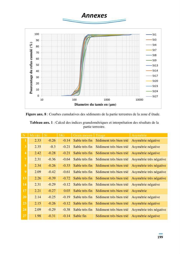
Figure anx. 8 : Courbes cumulatives des sédiments de la partie terrestres de la zone d’étude.
Tableau anx. 1 : Calcul des indices granulométriques et interprétation des résultats de la
partie terrestre.
N Mz (ϕ) Si
SKi
Grain moyen Triage
Asymétrie
1
2.33
-0.26
-0.14 Sable très fin Sédiment très bien trié Asymétrie négative
3
2.35
-0.3
-0.21 Sable très fin Sédiment très bien trié Asymétrie négative
4
2.42
-0.28
-0.21 Sable très fin Sédiment très bien trié Asymétrie négative
7
2.31
-0.36
-0.64 Sable très fin Sédiment très bien trié Asymétrie très négative
8
2.34
-0.26
-0.33 Sable très fin Sédiment très bien trié Asymétrie très négative
9
2.09
-0.42
-0.61 Sable très fin Sédiment très bien trié Asymétrie très négative
13
2.26
-0.39
-0.72 Sable très fin Sédiment très bien trié Asymétrie très négative
14
2.31
-0.29
-0.12 Sable très fin Sédiment très bien trié Asymétrie négative
17
2.21
-0.27
0.03 Sable très fin Sédiment très bien trié Asymétrie
20
2.14
-0.25
-0.19 Sable très fin Sédiment très bien trié Asymétrie négative
23
2.15
-0.26
-0.12 Sable très fin Sédiment très bien trié Asymétrie négative
24
2.09
-0.29
-0.38 Sable très fin Sédiment très bien trié Asymétrie très négative
27
1.98
-0.31
-0.14 Sable fin
Sédiment très bien trié Asymétrie négative
199
0
10
20
30
40
50
60
70
80
90
100
10
100
1000
10000
Pourcentage
du
refus
cumulé
(%)
Diametre du tamis en (µm)
St1
St3
St4
St7
St8
St9
St13
St14
St17
St20
St23
St24
St27
Figure anx. 8 : Courbes cumulatives des sédiments de la partie terrestres de la zone d’étude.
Tableau anx. 1 : Calcul des indices granulométriques et interprétation des résultats de la
partie terrestre.
N Mz (ϕ) Si
SKi
Grain moyen Triage
Asymétrie
1
2.33
-0.26
-0.14 Sable très fin Sédiment très bien trié Asymétrie négative
3
2.35
-0.3
-0.21 Sable très fin Sédiment très bien trié Asymétrie négative
4
2.42
-0.28
-0.21 Sable très fin Sédiment très bien trié Asymétrie négative
7
2.31
-0.36
-0.64 Sable très fin Sédiment très bien trié Asymétrie très négative
8
2.34
-0.26
-0.33 Sable très fin Sédiment très bien trié Asymétrie très négative
9
2.09
-0.42
-0.61 Sable très fin Sédiment très bien trié Asymétrie très négative
13
2.26
-0.39
-0.72 Sable très fin Sédiment très bien trié Asymétrie très négative
14
2.31
-0.29
-0.12 Sable très fin Sédiment très bien trié Asymétrie négative
17
2.21
-0.27
0.03 Sable très fin Sédiment très bien trié Asymétrie
20
2.14
-0.25
-0.19 Sable très fin Sédiment très bien trié Asymétrie négative
23
2.15
-0.26
-0.12 Sable très fin Sédiment très bien trié Asymétrie négative
24
2.09
-0.29
-0.38 Sable très fin Sédiment très bien trié Asymétrie très négative
27
1.98
-0.31
-0.14 Sable fin
Sédiment très bien trié Asymétrie négative