

71 Linking North American Summer Ozone Pollution Episodes …
447
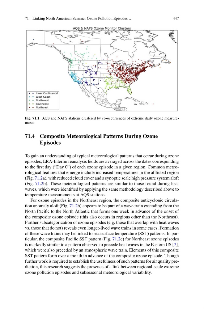
Fig. 71.1 AQS and NAPS stations clustered by co-occurrences of extreme daily ozone measurements
71.4 Composite Meteorological Patterns During Ozone
Episodes
To gain an understanding of typical meteorological patterns that occur during ozone
episodes, ERA-Interim reanalysis fields are averaged across the dates corresponding
to the first day (“Day 0”) of each ozone episode in a given region. Common meteorological features that emerge include increased temperatures in the afflicted region
(Fig. 71.2a), with reduced cloud cover and a synoptic scale high pressure system aloft
(Fig. 71.2b). These meteorological patterns are similar to those found during heat
waves, which were identified by applying the same methodology described above to
temperature measurements at AQS stations.
For ozone episodes in the Northeast region, the composite anticyclonic circulation anomaly aloft (Fig. 71.2b) appears to be part of a wave train extending from the
North Pacific to the North Atlantic that forms one week in advance of the onset of
the composite ozone episode (this also occurs in regions other than the Northeast).
Further subcategorization of ozone episodes (e.g. those that overlap with heat waves
vs. those that do not) reveals even longer-lived wave trains in some cases. Formation
of these wave trains may be linked to sea surface temperature (SST) patterns. In particular, the composite Pacific SST pattern (Fig. 71.2c) for Northeast ozone episodes
is markedly similar to a pattern observed to precede heat waves in the Eastern US [7],
which were also preceded by an atmospheric wave train. Elements of this composite
SST pattern form over a month in advance of the composite ozone episode. Though
further work is required to establish the usefulness of such patterns for air quality prediction, this research suggests the presence of a link between regional-scale extreme
ozone pollution episodes and subseasonal meteorological variability.
447
Fig. 71.1 AQS and NAPS stations clustered by co-occurrences of extreme daily ozone measurements
71.4 Composite Meteorological Patterns During Ozone
Episodes
To gain an understanding of typical meteorological patterns that occur during ozone
episodes, ERA-Interim reanalysis fields are averaged across the dates corresponding
to the first day (“Day 0”) of each ozone episode in a given region. Common meteorological features that emerge include increased temperatures in the afflicted region
(Fig. 71.2a), with reduced cloud cover and a synoptic scale high pressure system aloft
(Fig. 71.2b). These meteorological patterns are similar to those found during heat
waves, which were identified by applying the same methodology described above to
temperature measurements at AQS stations.
For ozone episodes in the Northeast region, the composite anticyclonic circulation anomaly aloft (Fig. 71.2b) appears to be part of a wave train extending from the
North Pacific to the North Atlantic that forms one week in advance of the onset of
the composite ozone episode (this also occurs in regions other than the Northeast).
Further subcategorization of ozone episodes (e.g. those that overlap with heat waves
vs. those that do not) reveals even longer-lived wave trains in some cases. Formation
of these wave trains may be linked to sea surface temperature (SST) patterns. In particular, the composite Pacific SST pattern (Fig. 71.2c) for Northeast ozone episodes
is markedly similar to a pattern observed to precede heat waves in the Eastern US [7],
which were also preceded by an atmospheric wave train. Elements of this composite
SST pattern form over a month in advance of the composite ozone episode. Though
further work is required to establish the usefulness of such patterns for air quality prediction, this research suggests the presence of a link between regional-scale extreme
ozone pollution episodes and subseasonal meteorological variability.