

55 Assessment of Fine-Scale Dispersion Modelling for Near-Road …
349
The DRIVE study was a 13-week sampling campaign (September 2014–December 2014) focusing on traffic related air pollutants (TRAPs) surrounding the busiest
highway in Atlanta, GA with an annual average daily traffic of 320,000 vehicles [1].
The study included six monitoring sites and focused on the Georgia Institute of Technology campus in the geographical core of Atlanta with its eastern edge bordering
the major highway. The sites included: a roadside location 10 m from the highway
(RD), an EPA Near-road Monitoring Network site located 70 m north of the RD
site and 5 m from the highway (EPD), a dormitory room 20 m from the highway
(ND), a dormitory room 1.4 km from the highway (FD), and an urban background
site located 2.3 km from the highway.
55.3 Results and Discussion
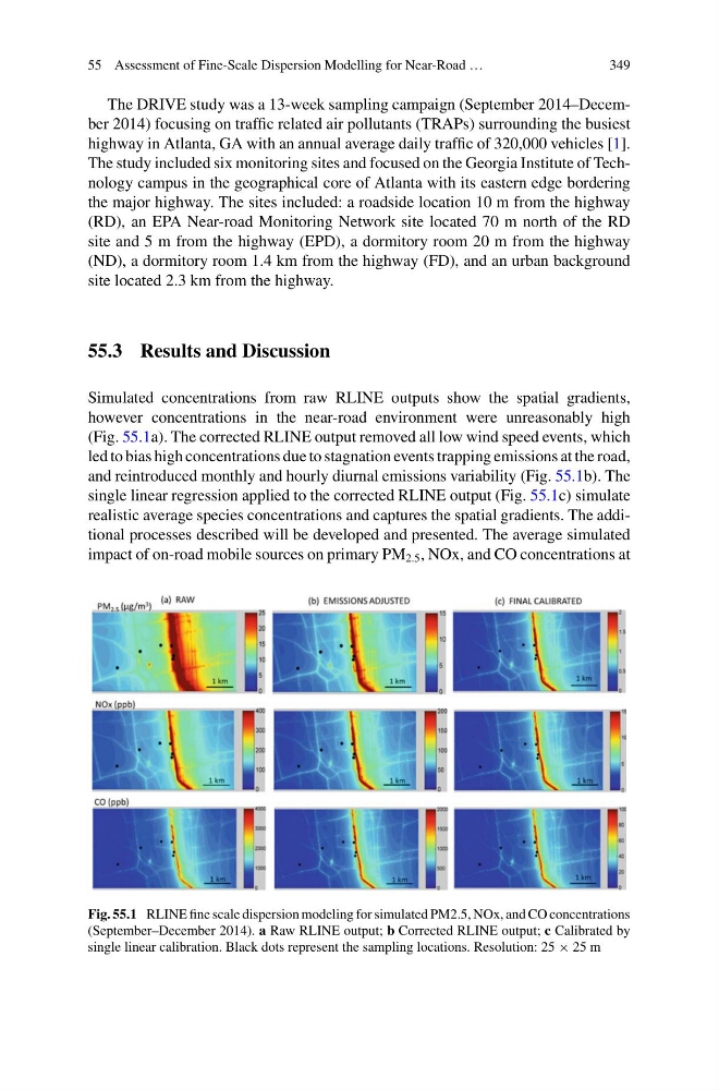
Simulated concentrations from raw RLINE outputs show the spatial gradients,
however concentrations in the near-road environment were unreasonably high
(Fig. 55.1a). The corrected RLINE output removed all low wind speed events, which
led to bias high concentrations due to stagnation events trapping emissions at the road,
and reintroduced monthly and hourly diurnal emissions variability (Fig. 55.1b). The
single linear regression applied to the corrected RLINE output (Fig. 55.1c) simulate
realistic average species concentrations and captures the spatial gradients. The additional processes described will be developed and presented. The average simulated
impact of on-road mobile sources on primary PM 2.5 , NOx, and CO concentrations at
Fig. 55.1 RLINE fine scale dispersion modeling for simulated PM2.5, NOx, and CO concentrations
(September–December 2014). a Raw RLINE output; b Corrected RLINE output; c Calibrated by
single linear calibration. Black dots represent the sampling locations. Resolution: 25 × 25 m
349
The DRIVE study was a 13-week sampling campaign (September 2014–December 2014) focusing on traffic related air pollutants (TRAPs) surrounding the busiest
highway in Atlanta, GA with an annual average daily traffic of 320,000 vehicles [1].
The study included six monitoring sites and focused on the Georgia Institute of Technology campus in the geographical core of Atlanta with its eastern edge bordering
the major highway. The sites included: a roadside location 10 m from the highway
(RD), an EPA Near-road Monitoring Network site located 70 m north of the RD
site and 5 m from the highway (EPD), a dormitory room 20 m from the highway
(ND), a dormitory room 1.4 km from the highway (FD), and an urban background
site located 2.3 km from the highway.
55.3 Results and Discussion
Simulated concentrations from raw RLINE outputs show the spatial gradients,
however concentrations in the near-road environment were unreasonably high
(Fig. 55.1a). The corrected RLINE output removed all low wind speed events, which
led to bias high concentrations due to stagnation events trapping emissions at the road,
and reintroduced monthly and hourly diurnal emissions variability (Fig. 55.1b). The
single linear regression applied to the corrected RLINE output (Fig. 55.1c) simulate
realistic average species concentrations and captures the spatial gradients. The additional processes described will be developed and presented. The average simulated
impact of on-road mobile sources on primary PM 2.5 , NOx, and CO concentrations at
Fig. 55.1 RLINE fine scale dispersion modeling for simulated PM2.5, NOx, and CO concentrations
(September–December 2014). a Raw RLINE output; b Corrected RLINE output; c Calibrated by
single linear calibration. Black dots represent the sampling locations. Resolution: 25 × 25 m