

Mapping Egypt Vulnerability to Sea Level Rise Scenarios
193
Web Server (Internet
Information Server- IIS)
Application Server
Internet
Web Browser
JavaScript
Interaction function
Google Maps APIs
Map Server
XMLHttpRequest
RDBMS
HTML
Http Request
XMLHttp Request
HTML
Spatial
Database
(Client Side)
(Server Side)
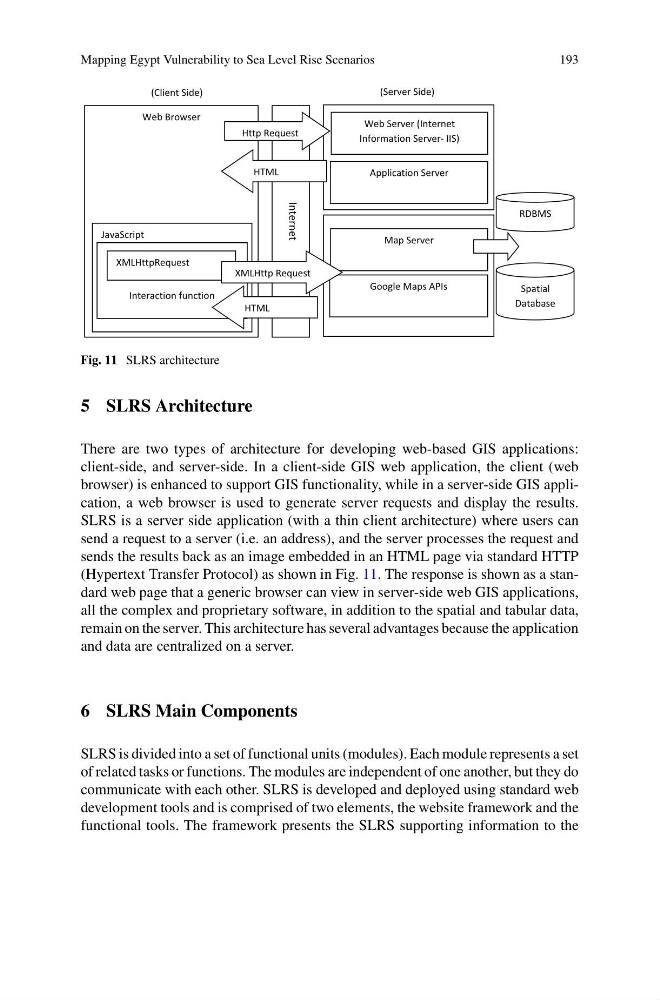
Fig. 11 SLRS architecture
5 SLRS Architecture
There are two types of architecture for developing web-based GIS applications:
client-side, and server-side. In a client-side GIS web application, the client (web
browser) is enhanced to support GIS functionality, while in a server-side GIS application, a web browser is used to generate server requests and display the results.
SLRS is a server side application (with a thin client architecture) where users can
send a request to a server (i.e. an address), and the server processes the request and
sends the results back as an image embedded in an HTML page via standard HTTP
(Hypertext Transfer Protocol) as shown in Fig. 11. The response is shown as a standard web page that a generic browser can view in server-side web GIS applications,
all the complex and proprietary software, in addition to the spatial and tabular data,
remain on the server. This architecture has several advantages because the application
and data are centralized on a server.
6 SLRS Main Components
SLRS is divided into a set of functional units (modules). Each module represents a set
of related tasks or functions. The modules are independent of one another, but they do
communicate with each other. SLRS is developed and deployed using standard web
development tools and is comprised of two elements, the website framework and the
functional tools. The framework presents the SLRS supporting information to the
193
Web Server (Internet
Information Server- IIS)
Application Server
Internet
Web Browser
JavaScript
Interaction function
Google Maps APIs
Map Server
XMLHttpRequest
RDBMS
HTML
Http Request
XMLHttp Request
HTML
Spatial
Database
(Client Side)
(Server Side)
Fig. 11 SLRS architecture
5 SLRS Architecture
There are two types of architecture for developing web-based GIS applications:
client-side, and server-side. In a client-side GIS web application, the client (web
browser) is enhanced to support GIS functionality, while in a server-side GIS application, a web browser is used to generate server requests and display the results.
SLRS is a server side application (with a thin client architecture) where users can
send a request to a server (i.e. an address), and the server processes the request and
sends the results back as an image embedded in an HTML page via standard HTTP
(Hypertext Transfer Protocol) as shown in Fig. 11. The response is shown as a standard web page that a generic browser can view in server-side web GIS applications,
all the complex and proprietary software, in addition to the spatial and tabular data,
remain on the server. This architecture has several advantages because the application
and data are centralized on a server.
6 SLRS Main Components
SLRS is divided into a set of functional units (modules). Each module represents a set
of related tasks or functions. The modules are independent of one another, but they do
communicate with each other. SLRS is developed and deployed using standard web
development tools and is comprised of two elements, the website framework and the
functional tools. The framework presents the SLRS supporting information to the