

258
environmental conditions. The climate in the Middle Draa valley is arid to hyperarid with an annual maximum precipitation of about 200 mm in the High Atlas
Mountains in the north and less than 30 mm in the south of the basin (Johannsen
et al. 2016). Temperatures range from −1 to −7 °C in winter to over 40 °C in summer
(Graf 2010).
The Draa River originates in the High Atlas Mountains at the confluence of the
Dades and Ouarzazate Rivers and runs over a 200 km long belt of six palm tree
oases to finally drain into the salt lake Lak Iriki. Since 1972, the river water flow is
managed through the Al Mansour Eddahbi reservoir (Graf 2010). The communities
in the Middle Draa valley depend on agriculture to sustain their livelihoods, which
makes them highly dependent on the scarce water resources (Box 15.1). According
to Heidecke (2009), the total water demand for agriculture in the entire Middle Draa
valley sums up to 300 million m
3
per year, whereas only about 3% of the total water
withdrawal is used for human consumption, but about 97% for agriculture. Due to
variability in rainfall, the inhabitants build more wells to extract groundwater, trying
to stabilize the water availability. Overuse of groundwater resources in combination
with persistent drought events, and possible future impacts of climate change are a
great challenge for the Middle Draa Valley (Karmaoui et al. 2014, 2016; Johannsen
et al. 2016).
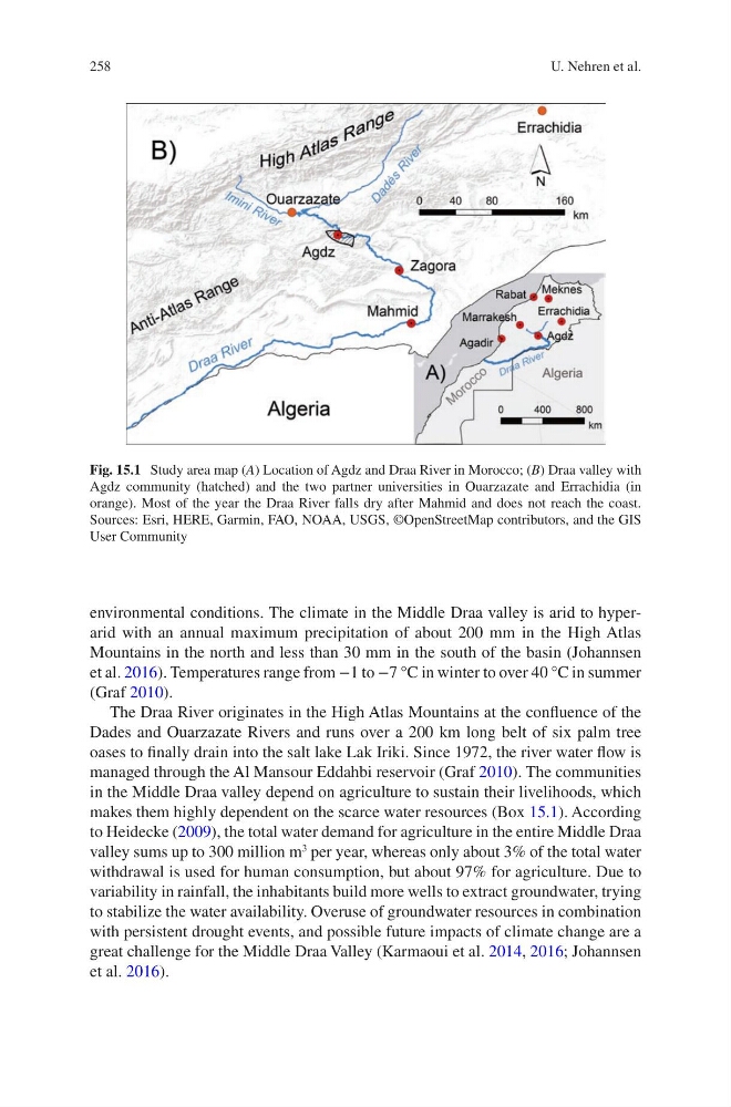
Fig. 15.1 Study area map (A) Location of Agdz and Draa River in Morocco; (B) Draa valley with
Agdz community (hatched) and the two partner universities in Ouarzazate and Errachidia (in
orange). Most of the year the Draa River falls dry after Mahmid and does not reach the coast.
Sources: Esri, HERE, Garmin, FAO, NOAA, USGS, ©OpenStreetMap contributors, and the GIS
User Community
U. Nehren et al.
environmental conditions. The climate in the Middle Draa valley is arid to hyperarid with an annual maximum precipitation of about 200 mm in the High Atlas
Mountains in the north and less than 30 mm in the south of the basin (Johannsen
et al. 2016). Temperatures range from −1 to −7 °C in winter to over 40 °C in summer
(Graf 2010).
The Draa River originates in the High Atlas Mountains at the confluence of the
Dades and Ouarzazate Rivers and runs over a 200 km long belt of six palm tree
oases to finally drain into the salt lake Lak Iriki. Since 1972, the river water flow is
managed through the Al Mansour Eddahbi reservoir (Graf 2010). The communities
in the Middle Draa valley depend on agriculture to sustain their livelihoods, which
makes them highly dependent on the scarce water resources (Box 15.1). According
to Heidecke (2009), the total water demand for agriculture in the entire Middle Draa
valley sums up to 300 million m
3
per year, whereas only about 3% of the total water
withdrawal is used for human consumption, but about 97% for agriculture. Due to
variability in rainfall, the inhabitants build more wells to extract groundwater, trying
to stabilize the water availability. Overuse of groundwater resources in combination
with persistent drought events, and possible future impacts of climate change are a
great challenge for the Middle Draa Valley (Karmaoui et al. 2014, 2016; Johannsen
et al. 2016).
Fig. 15.1 Study area map (A) Location of Agdz and Draa River in Morocco; (B) Draa valley with
Agdz community (hatched) and the two partner universities in Ouarzazate and Errachidia (in
orange). Most of the year the Draa River falls dry after Mahmid and does not reach the coast.
Sources: Esri, HERE, Garmin, FAO, NOAA, USGS, ©OpenStreetMap contributors, and the GIS
User Community
U. Nehren et al.