

150
community that co-manages the watershed as a long-term process, aiming to change
paradigms for the future design of regional plans.
Most coauthors have been into these planning efforts since the beginning (1993)
so our evaluation consisted in a chronological description of the main proposals of
each program and a compliance assessment was subsequently made indicating if the
strategy, goal, or action was met, if it was partially fulfilled, or if it was not carried
out. To demonstrate compliance with the actions proposed by each planning program, information was sought in official documents, government reports, by fieldwork and satellite images (Google Earth Pro). There are many other publications
and thesis on the subject, but these were especially important in the communication
of the regional planning efforts and resulting programs. In the last 30 years, the
watershed has been described as a socio-ecological system, since it is planned for
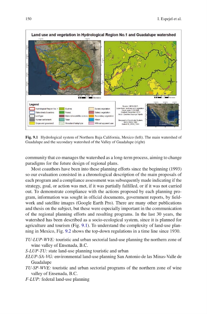
agriculture and tourism (Fig. 9.1). To understand the complexity of land-use planning in Mexico, Fig. 9.2 shows the top-down regulations in a time line since 1930.
TU-LUP-WVE: touristic and urban sectorial land-use planning the northern zone of
wine valley of Ensenada, B.C.
S-LUP-TU: state land-use planning touristic and urban
ELUP-SA-VG: environmental land-use planning San Antonio de las Minas-Valle de
Guadalupe
TU-SP-WVE: touristic and urban sectorial programs of the northern zone of wine
valley of Ensenada, B.C.
F-LUP: federal land-use planning
Fig. 9.1 Hydrological system of Northern Baja California, Mexico (left). The main watershed of
Guadalupe and the secondary watershed of the Valley of Guadalupe (right)
I. Espejel et al.
community that co-manages the watershed as a long-term process, aiming to change
paradigms for the future design of regional plans.
Most coauthors have been into these planning efforts since the beginning (1993)
so our evaluation consisted in a chronological description of the main proposals of
each program and a compliance assessment was subsequently made indicating if the
strategy, goal, or action was met, if it was partially fulfilled, or if it was not carried
out. To demonstrate compliance with the actions proposed by each planning program, information was sought in official documents, government reports, by fieldwork and satellite images (Google Earth Pro). There are many other publications
and thesis on the subject, but these were especially important in the communication
of the regional planning efforts and resulting programs. In the last 30 years, the
watershed has been described as a socio-ecological system, since it is planned for
agriculture and tourism (Fig. 9.1). To understand the complexity of land-use planning in Mexico, Fig. 9.2 shows the top-down regulations in a time line since 1930.
TU-LUP-WVE: touristic and urban sectorial land-use planning the northern zone of
wine valley of Ensenada, B.C.
S-LUP-TU: state land-use planning touristic and urban
ELUP-SA-VG: environmental land-use planning San Antonio de las Minas-Valle de
Guadalupe
TU-SP-WVE: touristic and urban sectorial programs of the northern zone of wine
valley of Ensenada, B.C.
F-LUP: federal land-use planning
Fig. 9.1 Hydrological system of Northern Baja California, Mexico (left). The main watershed of
Guadalupe and the secondary watershed of the Valley of Guadalupe (right)
I. Espejel et al.