

492
This paper presents an investigation of the availability, access to and use of
weather and climate information by smallholder famers in the Kilombero River
Catchment in Morogoro, Tanzania. The aim of the study is to: (i) understand the
demand for, availability and usefulness of weather and climate information; (ii)
assess diffusion methods, if and how information reaches farmers, and if not why;
and (iii) assess if weather and climate information is used for decision-making.
2 Materials and Methods
2.1 Description of the Study Area
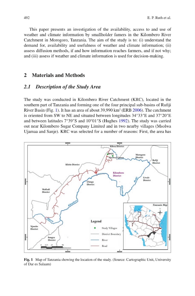
The study was conducted in Kilombero River Catchment (KRC), located in the
southern part of Tanzania and forming one of the four principal sub-basins of Rufiji
River Basin (Fig. 1). It has an area of about 39,990 km
2
(ERB 2006). The catchment
is oriented from SW to NE and situated between longitudes 34°33″E and 37°20″E
and between latitudes 7°39″S and 10°01″S (Hughes 1992). The study was carried
out near Kilombero Sugar Company Limited and in two nearby villages (Msolwa
Ujamaa and Sanje). KRC was selected for a number of reasons: First, the area has
Fig. 1 Map of Tanzania showing the location of the study. (Source: Cartographic Unit, University
of Dar es Salaam)
E. P. Ruth et al.
This paper presents an investigation of the availability, access to and use of
weather and climate information by smallholder famers in the Kilombero River
Catchment in Morogoro, Tanzania. The aim of the study is to: (i) understand the
demand for, availability and usefulness of weather and climate information; (ii)
assess diffusion methods, if and how information reaches farmers, and if not why;
and (iii) assess if weather and climate information is used for decision-making.
2 Materials and Methods
2.1 Description of the Study Area
The study was conducted in Kilombero River Catchment (KRC), located in the
southern part of Tanzania and forming one of the four principal sub-basins of Rufiji
River Basin (Fig. 1). It has an area of about 39,990 km
2
(ERB 2006). The catchment
is oriented from SW to NE and situated between longitudes 34°33″E and 37°20″E
and between latitudes 7°39″S and 10°01″S (Hughes 1992). The study was carried
out near Kilombero Sugar Company Limited and in two nearby villages (Msolwa
Ujamaa and Sanje). KRC was selected for a number of reasons: First, the area has
Fig. 1 Map of Tanzania showing the location of the study. (Source: Cartographic Unit, University
of Dar es Salaam)
E. P. Ruth et al.