

343
Although it is often underappreciated, computer science is one of the driving
forces of FEW research. From the collection of data using sensors and tools to the
conversion of these data to machine understandable code, as well as restructuring
and indexing the data for efficient storage and queries, computer science plays a big
role in FEW Nexus research. In addition, the manipulation of this data such as
merge, join, sort, aggregate, and analytics on these such as machine learning and
statistical analysis are made available by computer science. For example, the raw
analog temperature data collected from a wireless sensor is converted to bits, these
are stored in a short-term memory on the device, transferred through computer network by encapsulating in a specific network protocol, checked for the correctness of
the transfer by the computer algorithms on the receiver side, then transferred to a
database table by specific tags/column names. Once at the database table, this data
can be indexed by the location, time, and so on to make faster retrieval and queries
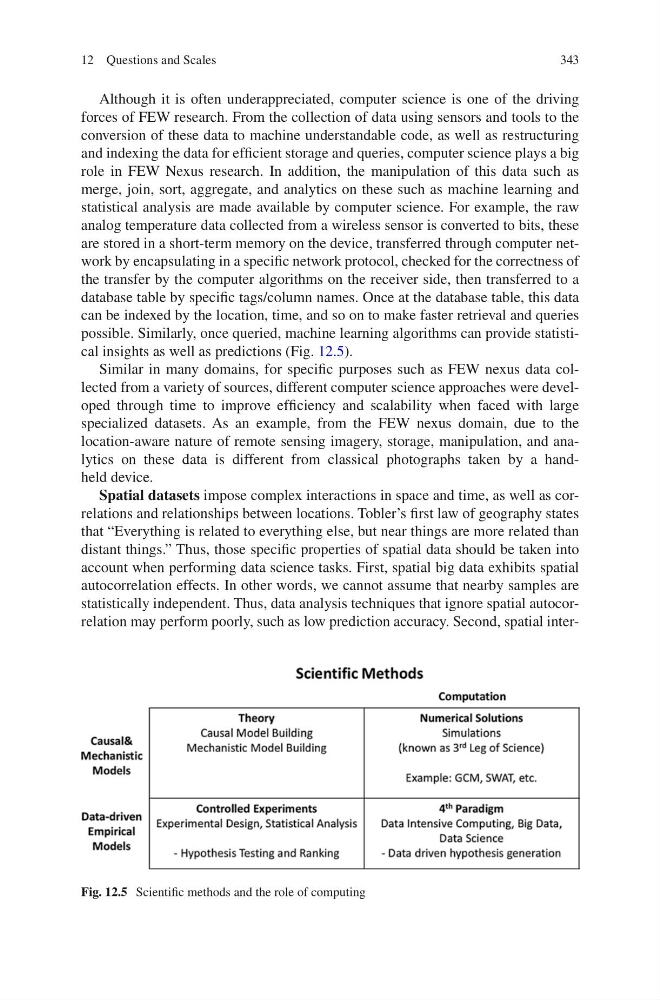
possible. Similarly, once queried, machine learning algorithms can provide statistical insights as well as predictions (Fig. 12.5).
Similar in many domains, for specific purposes such as FEW nexus data collected from a variety of sources, different computer science approaches were developed through time to improve efficiency and scalability when faced with large
specialized datasets. As an example, from the FEW nexus domain, due to the
location- aware nature of remote sensing imagery, storage, manipulation, and analytics on these data is different from classical photographs taken by a handheld device.
Spatial datasets impose complex interactions in space and time, as well as correlations and relationships between locations. Tobler’s first law of geography states
that “Everything is related to everything else, but near things are more related than
distant things.” Thus, those specific properties of spatial data should be taken into
account when performing data science tasks. First, spatial big data exhibits spatial
autocorrelation effects. In other words, we cannot assume that nearby samples are
statistically independent. Thus, data analysis techniques that ignore spatial autocorrelation may perform poorly, such as low prediction accuracy. Second, spatial interFig. 12.5 Scientific methods and the role of computing
12 Questions and Scales
Although it is often underappreciated, computer science is one of the driving
forces of FEW research. From the collection of data using sensors and tools to the
conversion of these data to machine understandable code, as well as restructuring
and indexing the data for efficient storage and queries, computer science plays a big
role in FEW Nexus research. In addition, the manipulation of this data such as
merge, join, sort, aggregate, and analytics on these such as machine learning and
statistical analysis are made available by computer science. For example, the raw
analog temperature data collected from a wireless sensor is converted to bits, these
are stored in a short-term memory on the device, transferred through computer network by encapsulating in a specific network protocol, checked for the correctness of
the transfer by the computer algorithms on the receiver side, then transferred to a
database table by specific tags/column names. Once at the database table, this data
can be indexed by the location, time, and so on to make faster retrieval and queries
possible. Similarly, once queried, machine learning algorithms can provide statistical insights as well as predictions (Fig. 12.5).
Similar in many domains, for specific purposes such as FEW nexus data collected from a variety of sources, different computer science approaches were developed through time to improve efficiency and scalability when faced with large
specialized datasets. As an example, from the FEW nexus domain, due to the
location- aware nature of remote sensing imagery, storage, manipulation, and analytics on these data is different from classical photographs taken by a handheld device.
Spatial datasets impose complex interactions in space and time, as well as correlations and relationships between locations. Tobler’s first law of geography states
that “Everything is related to everything else, but near things are more related than
distant things.” Thus, those specific properties of spatial data should be taken into
account when performing data science tasks. First, spatial big data exhibits spatial
autocorrelation effects. In other words, we cannot assume that nearby samples are
statistically independent. Thus, data analysis techniques that ignore spatial autocorrelation may perform poorly, such as low prediction accuracy. Second, spatial interFig. 12.5 Scientific methods and the role of computing
12 Questions and Scales