

Duke et al. 2007; Feka and Manzano 2008). For example, Balde et al. (2014a) found
extensive land use change due to agricultural activities at a site located in the
Dubreka prefecture. In particular, they found that 41.7% of the 5099 ha have
underwent substantial changes during between 1990 and 2010, with the upland
forest area affected substantially due to local population growth and farmer migration (Balde et al. 2014a).
Extensive areas of mangrove forest and abandoned shrimp farms in the Makinsi
district have been converted to paddy fields, with two mangrove rice production
techniques prevalent in the region (Balde et al. 2014b). Traditional mangrove rice
(TMR) farming is undertaken in cleared mangrove forestland, usually through slashand-burn. Small embankments enclose these farms, with rice planted on ridges as a
means of controlling the inflow of seawater and protecting the crop from crabs
(Balde et al. 2014b). The Guinean government has introduced some improved
mangrove rice (IMR) farming techniques performed in irrigated perimeters
surrounded by large embankments separated by dikes and floodgates (Balde et al.
2014b). The gates are opened during the dry season to allow seawater intrusion for
weed control and soil acidification prevention, while they remain closed during the
cropping season to prevent seawater intrusion into the rice fields (Balde et al. 2014b).
Some of the other common livelihood activities also affect mangrove forest
through fuelwood extraction. For example, fish drying and smoking consume an
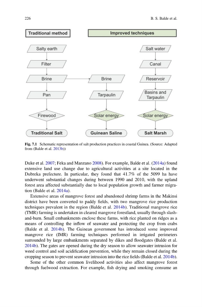
Fig. 7.1 Schematic representation of salt production practices in coastal Guinea. (Source: Adapted
from (Balde et al. 2013b))
226
B. S. Balde et al.
extensive land use change due to agricultural activities at a site located in the
Dubreka prefecture. In particular, they found that 41.7% of the 5099 ha have
underwent substantial changes during between 1990 and 2010, with the upland
forest area affected substantially due to local population growth and farmer migration (Balde et al. 2014a).
Extensive areas of mangrove forest and abandoned shrimp farms in the Makinsi
district have been converted to paddy fields, with two mangrove rice production
techniques prevalent in the region (Balde et al. 2014b). Traditional mangrove rice
(TMR) farming is undertaken in cleared mangrove forestland, usually through slashand-burn. Small embankments enclose these farms, with rice planted on ridges as a
means of controlling the inflow of seawater and protecting the crop from crabs
(Balde et al. 2014b). The Guinean government has introduced some improved
mangrove rice (IMR) farming techniques performed in irrigated perimeters
surrounded by large embankments separated by dikes and floodgates (Balde et al.
2014b). The gates are opened during the dry season to allow seawater intrusion for
weed control and soil acidification prevention, while they remain closed during the
cropping season to prevent seawater intrusion into the rice fields (Balde et al. 2014b).
Some of the other common livelihood activities also affect mangrove forest
through fuelwood extraction. For example, fish drying and smoking consume an
Fig. 7.1 Schematic representation of salt production practices in coastal Guinea. (Source: Adapted
from (Balde et al. 2013b))
226
B. S. Balde et al.