

465
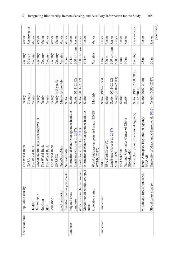
Socioeconomic Population density
The World Bank
Yearly
Country
Vector
NASA
5-yearly
30 arc s
Raster/vector
Health/
Demography
The World Bank
Yearly
Country
Vector
Global Health Data Exchange/WHO
Yearly
Country
Vector
Nutrition
The World Bank
Yearly
Country
Vector
GDP
The World Bank
Yearly
Country
Vector
Education
The World Bank
Yearly
Country
Vector
UNESCO
Yearly to 5-yearly
Country
Vector
Road networks
OpenStreetMap
Minutely- monthly
Variable
Vector
Roads/railroad/airports/ports
Natural Earth
Static
10 m
Vector
Land use
Irrigated areas
International Water Management Institute
Static
10 km
Raster
Land use
LandSense (Fritz et al. 2017)
Static (2011–2012)
300 m–1 km Raster
Wilderness and human impact LandSense (Fritz et al. 2017)
Static (2011–2012)
300 m–1 km Raster
Global map of rainfed cropped
areas
International Water Management Institute
Static
10 km
Raster
Protection status
World database on protected areas (UNEPWCMC 2017)
Monthly
Variable
Vector
Land cover
Land cover
USGS
Static (1992–1993)
1 km
Raster
ESA GlobCover V2
Static
300 m
Raster
LandSense (Fritz et al. 2017)
Static (2011–2012)
300 m–1 km Raster
MODIS12C1
Yearly (2001–2013)
500 m
Raster
FAO SHARE
Static
1 km
Raster
National Geomatics Center of China
GlobeLand30
Static
30 m
Raster
Corine (European Environment Agency)
Static (1990, 2000, 2006,
2012, 2018)
Country
Raster/vector
Mosaic and forest/non-forest
Japan Aerospace Exploration Agency
PALSAR
Static (2007–2010)
25 m
Raster
Global forest change
University of Maryland (Hansen et al. 2013) Yearly (2000–2017)
30 m
Raster
(continued)
17 Integrating Biodiversity, Remote Sensing, and Auxiliary Information for the Study…
Socioeconomic Population density
The World Bank
Yearly
Country
Vector
NASA
5-yearly
30 arc s
Raster/vector
Health/
Demography
The World Bank
Yearly
Country
Vector
Global Health Data Exchange/WHO
Yearly
Country
Vector
Nutrition
The World Bank
Yearly
Country
Vector
GDP
The World Bank
Yearly
Country
Vector
Education
The World Bank
Yearly
Country
Vector
UNESCO
Yearly to 5-yearly
Country
Vector
Road networks
OpenStreetMap
Minutely- monthly
Variable
Vector
Roads/railroad/airports/ports
Natural Earth
Static
10 m
Vector
Land use
Irrigated areas
International Water Management Institute
Static
10 km
Raster
Land use
LandSense (Fritz et al. 2017)
Static (2011–2012)
300 m–1 km Raster
Wilderness and human impact LandSense (Fritz et al. 2017)
Static (2011–2012)
300 m–1 km Raster
Global map of rainfed cropped
areas
International Water Management Institute
Static
10 km
Raster
Protection status
World database on protected areas (UNEPWCMC 2017)
Monthly
Variable
Vector
Land cover
Land cover
USGS
Static (1992–1993)
1 km
Raster
ESA GlobCover V2
Static
300 m
Raster
LandSense (Fritz et al. 2017)
Static (2011–2012)
300 m–1 km Raster
MODIS12C1
Yearly (2001–2013)
500 m
Raster
FAO SHARE
Static
1 km
Raster
National Geomatics Center of China
GlobeLand30
Static
30 m
Raster
Corine (European Environment Agency)
Static (1990, 2000, 2006,
2012, 2018)
Country
Raster/vector
Mosaic and forest/non-forest
Japan Aerospace Exploration Agency
PALSAR
Static (2007–2010)
25 m
Raster
Global forest change
University of Maryland (Hansen et al. 2013) Yearly (2000–2017)
30 m
Raster
(continued)
17 Integrating Biodiversity, Remote Sensing, and Auxiliary Information for the Study…