

439
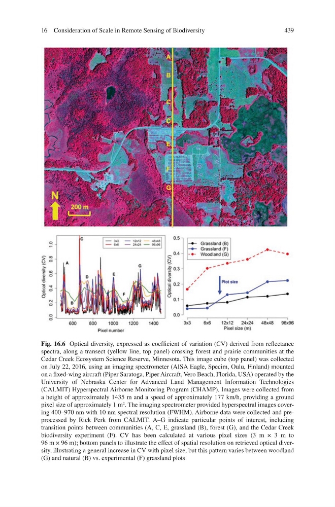
Fig. 16.6 Optical diversity, expressed as coefficient of variation (CV) derived from reflectance
spectra, along a transect (yellow line, top panel) crossing forest and prairie communities at the
Cedar Creek Ecosystem Science Reserve, Minnesota. This image cube (top panel) was collected
on July 22, 2016, using an imaging spectrometer (AISA Eagle, Specim, Oulu, Finland) mounted
on a fixed-wing aircraft (Piper Saratoga, Piper Aircraft, Vero Beach, Florida, USA) operated by the
University of Nebraska Center for Advanced Land Management Information Technologies
(CALMIT) Hyperspectral Airborne Monitoring Program (CHAMP). Images were collected from
a height of approximately 1435 m and a speed of approximately 177 km/h, providing a ground
pixel size of approximately 1 m
2
. The imaging spectrometer provided hyperspectral images covering 400–970 nm with 10 nm spectral resolution (FWHM). Airborne data were collected and preprocessed by Rick Perk from CALMIT. A–G indicate particular points of interest, including
transition points between communities (A, C, E, grassland (B), forest (G), and the Cedar Creek
biodiversity experiment (F). CV has been calculated at various pixel sizes (3 m × 3 m to
96 m × 96 m); bottom panels to illustrate the effect of spatial resolution on retrieved optical diversity, illustrating a general increase in CV with pixel size, but this pattern varies between woodland
(G) and natural (B) vs. experimental (F) grassland plots
16 Consideration of Scale in Remote Sensing of Biodiversity
Fig. 16.6 Optical diversity, expressed as coefficient of variation (CV) derived from reflectance
spectra, along a transect (yellow line, top panel) crossing forest and prairie communities at the
Cedar Creek Ecosystem Science Reserve, Minnesota. This image cube (top panel) was collected
on July 22, 2016, using an imaging spectrometer (AISA Eagle, Specim, Oulu, Finland) mounted
on a fixed-wing aircraft (Piper Saratoga, Piper Aircraft, Vero Beach, Florida, USA) operated by the
University of Nebraska Center for Advanced Land Management Information Technologies
(CALMIT) Hyperspectral Airborne Monitoring Program (CHAMP). Images were collected from
a height of approximately 1435 m and a speed of approximately 177 km/h, providing a ground
pixel size of approximately 1 m
2
. The imaging spectrometer provided hyperspectral images covering 400–970 nm with 10 nm spectral resolution (FWHM). Airborne data were collected and preprocessed by Rick Perk from CALMIT. A–G indicate particular points of interest, including
transition points between communities (A, C, E, grassland (B), forest (G), and the Cedar Creek
biodiversity experiment (F). CV has been calculated at various pixel sizes (3 m × 3 m to
96 m × 96 m); bottom panels to illustrate the effect of spatial resolution on retrieved optical diversity, illustrating a general increase in CV with pixel size, but this pattern varies between woodland
(G) and natural (B) vs. experimental (F) grassland plots
16 Consideration of Scale in Remote Sensing of Biodiversity