

403
relevant for answering a specific research question. Extending the calibrated range
beyond the range of values for which predictions are being made generally decreases
model accuracy for these values, as compared to a more narrowly defined model
that fits that range.
For classification models, including empirical-statistical clustering and supervised classification methods, covering all classes of interest with a similar and sufficiently large number of samples is also important. However, the range of values/
environmental conditions question is more nuanced. On the one hand, it can be
advantageous to include all major classes as end-members for classification, even
when not all of them are of interest for prediction. For example, when the aim is to
differentiate broadleaf and needleleaf forest using remotely sensed imagery, it
makes sense to include other classes present in the image, such as grasslands, roads,
and water bodies, as well. The reason is that when broadleaf and needleleaf forest
are the only two classes used for model calibration, the model will, when applied to
the full image, try to assign grassland, road, and water pixels to these two forest
types, decreasing model accuracy. On the other hand, too many extra classes can
make it difficult for a model to differentiate among the classes of interest. If one is
interested in differentiating two forest types, it would probably not make sense to
use tree species as input classes, because a species differentiation model is likely
overall less accurate than a model trained on just the two forest types of interest.
Stepwise approaches to such classification problems are often helpful. First, one
could differentiate broader classes such as vegetation, roads, and water bodies from
each other; then, forest from grassland within the vegetation class; and finally different forest types within the forest class (for more details see textbooks on remote
sensing of vegetation, e.g., Jones and Vaughan 2010; Thenkabail et al. 2012, and
specific topics, such as on deep learning approaches to image classification, e.g.,
Cholet and Allair 2018).
Areas from within the calibrated value range are usually prioritized during model
interpretation. Nevertheless, visits to areas with vegetation or other site characteristics at the edge of or beyond the calibrated range can be insightful regarding the
measured values
a
b
c
predicted values
measured values
predicted values
measured values
predicted values
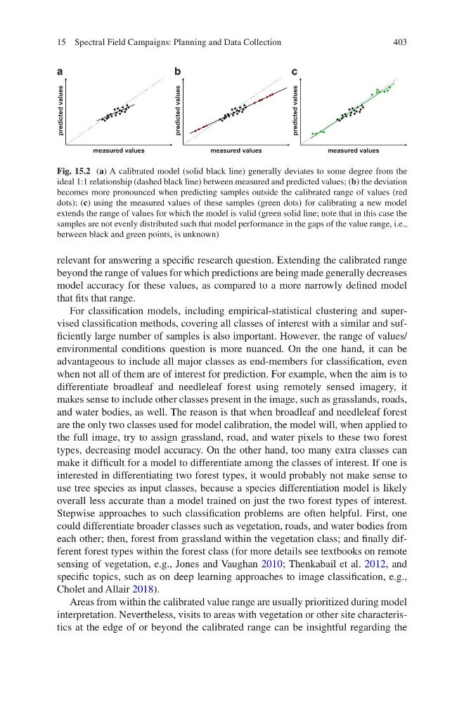
Fig. 15.2 (a) A calibrated model (solid black line) generally deviates to some degree from the
ideal 1:1 relationship (dashed black line) between measured and predicted values; (b) the deviation
becomes more pronounced when predicting samples outside the calibrated range of values (red
dots); (c) using the measured values of these samples (green dots) for calibrating a new model
extends the range of values for which the model is valid (green solid line; note that in this case the
samples are not evenly distributed such that model performance in the gaps of the value range, i.e.,
between black and green points, is unknown)
15 Spectral Field Campaigns: Planning and Data Collection
relevant for answering a specific research question. Extending the calibrated range
beyond the range of values for which predictions are being made generally decreases
model accuracy for these values, as compared to a more narrowly defined model
that fits that range.
For classification models, including empirical-statistical clustering and supervised classification methods, covering all classes of interest with a similar and sufficiently large number of samples is also important. However, the range of values/
environmental conditions question is more nuanced. On the one hand, it can be
advantageous to include all major classes as end-members for classification, even
when not all of them are of interest for prediction. For example, when the aim is to
differentiate broadleaf and needleleaf forest using remotely sensed imagery, it
makes sense to include other classes present in the image, such as grasslands, roads,
and water bodies, as well. The reason is that when broadleaf and needleleaf forest
are the only two classes used for model calibration, the model will, when applied to
the full image, try to assign grassland, road, and water pixels to these two forest
types, decreasing model accuracy. On the other hand, too many extra classes can
make it difficult for a model to differentiate among the classes of interest. If one is
interested in differentiating two forest types, it would probably not make sense to
use tree species as input classes, because a species differentiation model is likely
overall less accurate than a model trained on just the two forest types of interest.
Stepwise approaches to such classification problems are often helpful. First, one
could differentiate broader classes such as vegetation, roads, and water bodies from
each other; then, forest from grassland within the vegetation class; and finally different forest types within the forest class (for more details see textbooks on remote
sensing of vegetation, e.g., Jones and Vaughan 2010; Thenkabail et al. 2012, and
specific topics, such as on deep learning approaches to image classification, e.g.,
Cholet and Allair 2018).
Areas from within the calibrated value range are usually prioritized during model
interpretation. Nevertheless, visits to areas with vegetation or other site characteristics at the edge of or beyond the calibrated range can be insightful regarding the
measured values
a
b
c
predicted values
measured values
predicted values
measured values
predicted values
Fig. 15.2 (a) A calibrated model (solid black line) generally deviates to some degree from the
ideal 1:1 relationship (dashed black line) between measured and predicted values; (b) the deviation
becomes more pronounced when predicting samples outside the calibrated range of values (red
dots); (c) using the measured values of these samples (green dots) for calibrating a new model
extends the range of values for which the model is valid (green solid line; note that in this case the
samples are not evenly distributed such that model performance in the gaps of the value range, i.e.,
between black and green points, is unknown)
15 Spectral Field Campaigns: Planning and Data Collection