

287
comprehensive reviews of the approach). These approaches are often preferred
because, being physics-based, they are in principle generalizable and transferable
across sensors and systems (Giardino et al. 2010, 2012; Malthus et al. 2012; Hestir
et al. 2015). However, such approaches require detailed spectral information on
specific water body IOPs, which are difficult to collect and not generally available
(Matthews 2011; Lymburner et al. 2016). In these approaches, bottom type is typically mapped to just a few broad classes (e.g., sand/sediment, rock, submerged
plants, coral), so species-level detections are not common in the literature (Dörnhöfer
and Oppelt 2016). However, Santos et al. (2012) were able to show species-level
discrimination of submerged macrophytes at the leaf level and could differentiate
native from non-native submerged macrophytes at the canopy level from HyMap
airborne imaging spectroscopy in a turbid estuary in California.
Often the dominant species is invasive, so even community-level maps can still
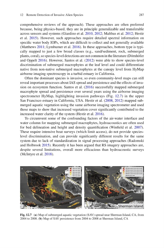
reveal important processes about IAS spread and persistence and the effects of invasion on ecosystem function. Santos et al. (2016) successfully mapped submerged
macrophyte spread and persistence over several years using the airborne imaging
spectrometer HyMap, highlighting invasion pathways (Fig. 12.7) in the upper
San Francisco estuary in California, USA. Hestir et al. (2008, 2012) mapped submerged aquatic vegetation using the same airborne imaging spectrometer and used
those maps to show that increased vegetation cover significantly contributed to the
increased water clarity of the system (Hestir et al. 2016).
To circumvent some of the confounding factors of the air-water interface and
water column for mapping submerged macrophytes, hydroacoustics are often used
for bed delineation and height and density quantification (Winfield et al. 2007).
These require intensive boat surveys (which limit access), do not provide specieslevel discrimination, and can provide significantly different results for the same
system due to lack of standardization in signal processing approaches (Radomski
and Holbrook 2015). Recently it has been argued that RS imagery approaches are,
despite several limitations, overall more efficacious than hydroacoustic surveys
(McIntyre et al. 2018).
Fig. 12.7 (a) Map of submerged aquatic vegetation (SAV) spread near Sherman Island, CA, from
2004 to 2008. (b) Map of SAV persistence from 2004 to 2008 at Sherman Island, CA
12 Remote Detection of Invasive Alien Species
comprehensive reviews of the approach). These approaches are often preferred
because, being physics-based, they are in principle generalizable and transferable
across sensors and systems (Giardino et al. 2010, 2012; Malthus et al. 2012; Hestir
et al. 2015). However, such approaches require detailed spectral information on
specific water body IOPs, which are difficult to collect and not generally available
(Matthews 2011; Lymburner et al. 2016). In these approaches, bottom type is typically mapped to just a few broad classes (e.g., sand/sediment, rock, submerged
plants, coral), so species-level detections are not common in the literature (Dörnhöfer
and Oppelt 2016). However, Santos et al. (2012) were able to show species-level
discrimination of submerged macrophytes at the leaf level and could differentiate
native from non-native submerged macrophytes at the canopy level from HyMap
airborne imaging spectroscopy in a turbid estuary in California.
Often the dominant species is invasive, so even community-level maps can still
reveal important processes about IAS spread and persistence and the effects of invasion on ecosystem function. Santos et al. (2016) successfully mapped submerged
macrophyte spread and persistence over several years using the airborne imaging
spectrometer HyMap, highlighting invasion pathways (Fig. 12.7) in the upper
San Francisco estuary in California, USA. Hestir et al. (2008, 2012) mapped submerged aquatic vegetation using the same airborne imaging spectrometer and used
those maps to show that increased vegetation cover significantly contributed to the
increased water clarity of the system (Hestir et al. 2016).
To circumvent some of the confounding factors of the air-water interface and
water column for mapping submerged macrophytes, hydroacoustics are often used
for bed delineation and height and density quantification (Winfield et al. 2007).
These require intensive boat surveys (which limit access), do not provide specieslevel discrimination, and can provide significantly different results for the same
system due to lack of standardization in signal processing approaches (Radomski
and Holbrook 2015). Recently it has been argued that RS imagery approaches are,
despite several limitations, overall more efficacious than hydroacoustic surveys
(McIntyre et al. 2018).
Fig. 12.7 (a) Map of submerged aquatic vegetation (SAV) spread near Sherman Island, CA, from
2004 to 2008. (b) Map of SAV persistence from 2004 to 2008 at Sherman Island, CA
12 Remote Detection of Invasive Alien Species