

141
relative levels of forest decline. The recent addition of improved satellite sensors
(e.g., Sentinel 2) is rapidly increasing the capability to cover broad landscapes at
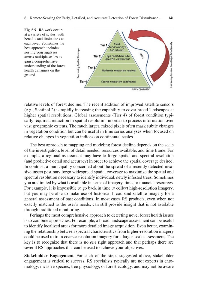
higher spatial resolutions. Global assessments (Tier 4) of forest condition typically require a reduction in spatial resolution in order to process information over
vast geographic extents. The much larger, mixed pixels often mask subtle changes
in vegetation condition but can be useful in time series analyses when focused on
relative changes in vegetation indices on continental scales.
The best approach to mapping and modeling forest decline depends on the scale
of the investigation, level of detail needed, resources available, and time frame. For
example, a regional assessment may have to forgo spatial and spectral resolution
(and predictive detail and accuracy) in order to achieve the spatial coverage desired.
In contrast, a municipality concerned about the spread of a recently detected invasive insect pest may forgo widespread spatial coverage to maximize the spatial and
spectral resolution necessary to identify individual, newly infested trees. Sometimes
you are limited by what is available in terms of imagery, time, or financial resources.
For example, it is impossible to go back in time to collect high-resolution imagery,
but you may be able to make use of historical broadband satellite imagery for a
general assessment of past conditions. In most cases RS products, even when not
exactly matched to the user’s needs, can still provide insight that is not available
through traditional monitoring.
Perhaps the most comprehensive approach to detecting novel forest health issues
is to combine approaches. For example, a broad landscape assessment can be useful
to identify localized areas for more detailed image acquisition. Even better, examining the relationship between spectral characteristics from higher-resolution imagery
could be used to train coarser resolution imagery for a larger-scale assessment. The
key is to recognize that there is no one right approach and that perhaps there are
several RS approaches that can be used to achieve your objectives.
Stakeholder Engagement For each of the steps suggested above, stakeholder
engagement is critical to success. RS specialists typically are not experts in entomology, invasive species, tree physiology, or forest ecology, and may not be aware
Fig. 6.9 RS work occurs
at a variety of scales, with
benefits and limitations at
each level. Sometimes the
best approach includes
nesting your analyses
across multiple scales to
gain a comprehensive
understanding of the forest
health dynamics on the
ground
6 Remote Sensing for Early, Detailed, and Accurate Detection of Forest Disturbance…
relative levels of forest decline. The recent addition of improved satellite sensors
(e.g., Sentinel 2) is rapidly increasing the capability to cover broad landscapes at
higher spatial resolutions. Global assessments (Tier 4) of forest condition typically require a reduction in spatial resolution in order to process information over
vast geographic extents. The much larger, mixed pixels often mask subtle changes
in vegetation condition but can be useful in time series analyses when focused on
relative changes in vegetation indices on continental scales.
The best approach to mapping and modeling forest decline depends on the scale
of the investigation, level of detail needed, resources available, and time frame. For
example, a regional assessment may have to forgo spatial and spectral resolution
(and predictive detail and accuracy) in order to achieve the spatial coverage desired.
In contrast, a municipality concerned about the spread of a recently detected invasive insect pest may forgo widespread spatial coverage to maximize the spatial and
spectral resolution necessary to identify individual, newly infested trees. Sometimes
you are limited by what is available in terms of imagery, time, or financial resources.
For example, it is impossible to go back in time to collect high-resolution imagery,
but you may be able to make use of historical broadband satellite imagery for a
general assessment of past conditions. In most cases RS products, even when not
exactly matched to the user’s needs, can still provide insight that is not available
through traditional monitoring.
Perhaps the most comprehensive approach to detecting novel forest health issues
is to combine approaches. For example, a broad landscape assessment can be useful
to identify localized areas for more detailed image acquisition. Even better, examining the relationship between spectral characteristics from higher-resolution imagery
could be used to train coarser resolution imagery for a larger-scale assessment. The
key is to recognize that there is no one right approach and that perhaps there are
several RS approaches that can be used to achieve your objectives.
Stakeholder Engagement For each of the steps suggested above, stakeholder
engagement is critical to success. RS specialists typically are not experts in entomology, invasive species, tree physiology, or forest ecology, and may not be aware
Fig. 6.9 RS work occurs
at a variety of scales, with
benefits and limitations at
each level. Sometimes the
best approach includes
nesting your analyses
across multiple scales to
gain a comprehensive
understanding of the forest
health dynamics on the
ground
6 Remote Sensing for Early, Detailed, and Accurate Detection of Forest Disturbance…