

93
is normally a pixel. Linking these different perspectives can be difficult under any
circumstances; the Laegeren site is situated on a steep slope, and trees have irregular
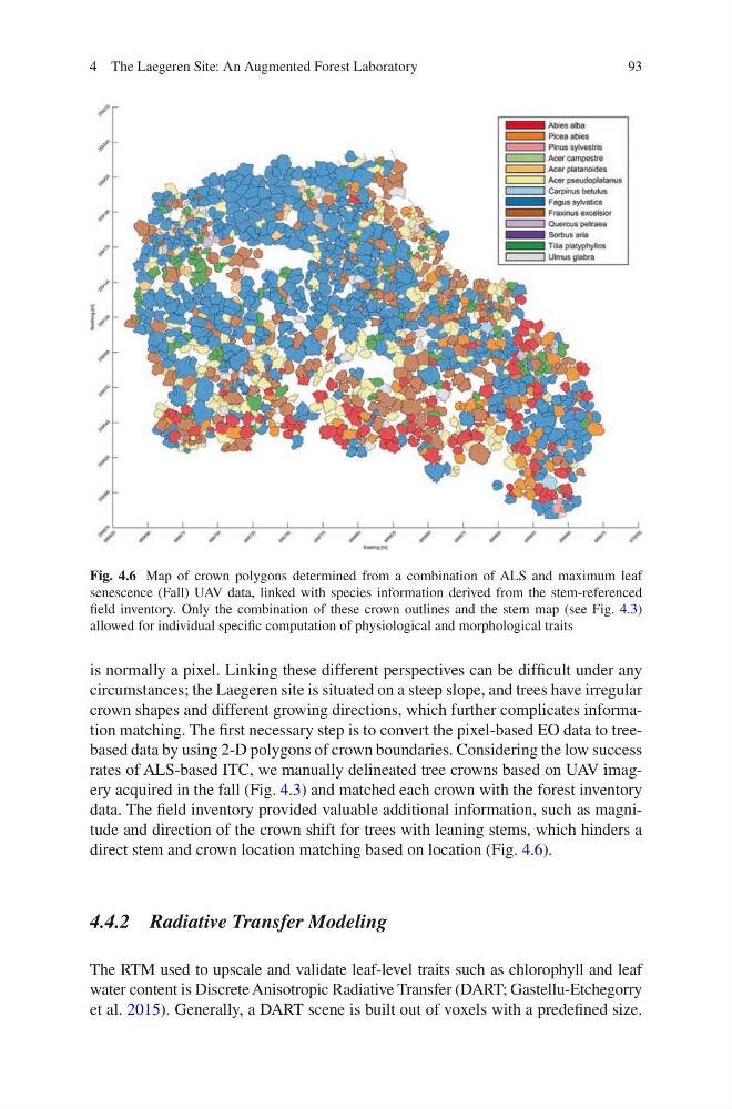
crown shapes and different growing directions, which further complicates information matching. The first necessary step is to convert the pixel-based EO data to treebased data by using 2-D polygons of crown boundaries. Considering the low success
rates of ALS-based ITC, we manually delineated tree crowns based on UAV imagery acquired in the fall (Fig. 4.3) and matched each crown with the forest inventory
data. The field inventory provided valuable additional information, such as magnitude and direction of the crown shift for trees with leaning stems, which hinders a
direct stem and crown location matching based on location (Fig. 4.6).
4.4.2 Radiative Transfer Modeling
The RTM used to upscale and validate leaf-level traits such as chlorophyll and leaf
water content is Discrete Anisotropic Radiative Transfer (DART; Gastellu- Etchegorry
et al. 2015). Generally, a DART scene is built out of voxels with a predefined size.
Fig. 4.6 Map of crown polygons determined from a combination of ALS and maximum leaf
senescence (Fall) UAV data, linked with species information derived from the stem-referenced
field inventory. Only the combination of these crown outlines and the stem map (see Fig. 4.3)
allowed for individual specific computation of physiological and morphological traits
4 The Laegeren Site: An Augmented Forest Laboratory
is normally a pixel. Linking these different perspectives can be difficult under any
circumstances; the Laegeren site is situated on a steep slope, and trees have irregular
crown shapes and different growing directions, which further complicates information matching. The first necessary step is to convert the pixel-based EO data to treebased data by using 2-D polygons of crown boundaries. Considering the low success
rates of ALS-based ITC, we manually delineated tree crowns based on UAV imagery acquired in the fall (Fig. 4.3) and matched each crown with the forest inventory
data. The field inventory provided valuable additional information, such as magnitude and direction of the crown shift for trees with leaning stems, which hinders a
direct stem and crown location matching based on location (Fig. 4.6).
4.4.2 Radiative Transfer Modeling
The RTM used to upscale and validate leaf-level traits such as chlorophyll and leaf
water content is Discrete Anisotropic Radiative Transfer (DART; Gastellu- Etchegorry
et al. 2015). Generally, a DART scene is built out of voxels with a predefined size.
Fig. 4.6 Map of crown polygons determined from a combination of ALS and maximum leaf
senescence (Fall) UAV data, linked with species information derived from the stem-referenced
field inventory. Only the combination of these crown outlines and the stem map (see Fig. 4.3)
allowed for individual specific computation of physiological and morphological traits
4 The Laegeren Site: An Augmented Forest Laboratory