

Site
Secondary
primary source
source
Elevation (mAHD)
–10
20
Proposed
Fill
PRB locations Regional
Guildford
Formation
Damplands watertable
Escarpment
10
0
Leederville Formation
Alluvium
Transitional
zone
B
North
0
25
50 meters
B'
South
114
Permeable Reactive Barrier
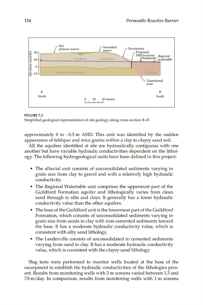
FIGURE 7.2
Simplified geological representation of site geology along cross-section B–B′.
approximately 0 to −0.5 m AHD. This unit was identified by the sudden
appearance of feldspar and mica grains within a clay to clayey sand soil.
All the aquifers identified at site are hydraulically contiguous with one
another but have variable hydraulic conductivities dependent on the lithology. The following hydrogeological units have been defined in this project:
• The alluvial unit consists of unconsolidated sediments varying in
grain size from clay to gravel and with a relatively high hydraulic
conductivity.
• The Regional Watertable unit comprises the uppermost part of the
Guildford Formation aquifer and lithologically varies from clean
sand through to silts and clays. It generally has a lower hydraulic
conductivity value than the other aquifers.
• The base of the Guildford unit is the lowermost part of the Guildford
Formation, which consists of unconsolidated sediments varying in
grain size from sands to clay with iron-cemented sediments toward
the base. It has a moderate hydraulic conductivity value, which is
consistent with silty sand lithology.
• The Leederville consists of unconsolidated to cemented sediments
varying from sand to clay. It has a moderate hydraulic conductivity
value, which is consistent with the clayey sand lithology.
Slug tests were performed to monitor wells located at the base of the
escarpment to establish the hydraulic conductivities of the lithologies present. Results from monitoring wells with 3 m screens varied between 1.3 and
7.8 m/day. In comparison, results from monitoring wells with 1 m screens
Secondary
primary source
source
Elevation (mAHD)
–10
20
Proposed
Fill
PRB locations Regional
Guildford
Formation
Damplands watertable
Escarpment
10
0
Leederville Formation
Alluvium
Transitional
zone
B
North
0
25
50 meters
B'
South
114
Permeable Reactive Barrier
FIGURE 7.2
Simplified geological representation of site geology along cross-section B–B′.
approximately 0 to −0.5 m AHD. This unit was identified by the sudden
appearance of feldspar and mica grains within a clay to clayey sand soil.
All the aquifers identified at site are hydraulically contiguous with one
another but have variable hydraulic conductivities dependent on the lithology. The following hydrogeological units have been defined in this project:
• The alluvial unit consists of unconsolidated sediments varying in
grain size from clay to gravel and with a relatively high hydraulic
conductivity.
• The Regional Watertable unit comprises the uppermost part of the
Guildford Formation aquifer and lithologically varies from clean
sand through to silts and clays. It generally has a lower hydraulic
conductivity value than the other aquifers.
• The base of the Guildford unit is the lowermost part of the Guildford
Formation, which consists of unconsolidated sediments varying in
grain size from sands to clay with iron-cemented sediments toward
the base. It has a moderate hydraulic conductivity value, which is
consistent with silty sand lithology.
• The Leederville consists of unconsolidated to cemented sediments
varying from sand to clay. It has a moderate hydraulic conductivity
value, which is consistent with the clayey sand lithology.
Slug tests were performed to monitor wells located at the base of the
escarpment to establish the hydraulic conductivities of the lithologies present. Results from monitoring wells with 3 m screens varied between 1.3 and
7.8 m/day. In comparison, results from monitoring wells with 1 m screens