

own environment. In the implementation of CropScape, the open-source JavaScript
libraries ExtJS (Sencha 2017) and OpenLayers (OpenLayers 2017) are used to
develop an Ajax-powered rich Internet application which can be accessed through
most common browsers, for example, Internet Explorer, Firefox, Safari, Opera, and
Chrome, without installing any additional software or plugin (Han et al. 2012).
18.4.1.2 Service Layer
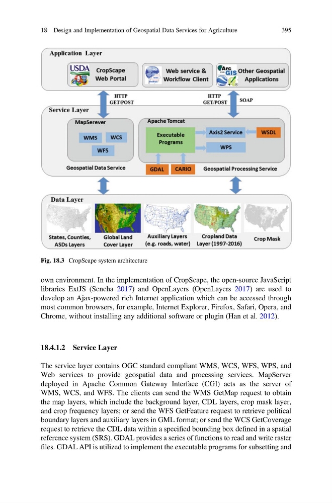
The service layer contains OGC standard compliant WMS, WCS, WFS, WPS, and
Web services to provide geospatial data and processing services. MapServer
deployed in Apache Common Gateway Interface (CGI) acts as the server of
WMS, WCS, and WFS. The clients can send the WMS GetMap request to obtain
the map layers, which include the background layer, CDL layers, crop mask layer,
and crop frequency layers; or send the WFS GetFeature request to retrieve political
boundary layers and auxiliary layers in GML format; or send the WCS GetCoverage
request to retrieve the CDL data within a specified bounding box defined in a spatial
reference system (SRS). GDAL provides a series of functions to read and write raster
files. GDAL API is utilized to implement the executable programs for subsetting and
Fig. 18.3 CropScape system architecture
18 Design and Implementation of Geospatial Data Services for Agriculture
395
libraries ExtJS (Sencha 2017) and OpenLayers (OpenLayers 2017) are used to
develop an Ajax-powered rich Internet application which can be accessed through
most common browsers, for example, Internet Explorer, Firefox, Safari, Opera, and
Chrome, without installing any additional software or plugin (Han et al. 2012).
18.4.1.2 Service Layer
The service layer contains OGC standard compliant WMS, WCS, WFS, WPS, and
Web services to provide geospatial data and processing services. MapServer
deployed in Apache Common Gateway Interface (CGI) acts as the server of
WMS, WCS, and WFS. The clients can send the WMS GetMap request to obtain
the map layers, which include the background layer, CDL layers, crop mask layer,
and crop frequency layers; or send the WFS GetFeature request to retrieve political
boundary layers and auxiliary layers in GML format; or send the WCS GetCoverage
request to retrieve the CDL data within a specified bounding box defined in a spatial
reference system (SRS). GDAL provides a series of functions to read and write raster
files. GDAL API is utilized to implement the executable programs for subsetting and
Fig. 18.3 CropScape system architecture
18 Design and Implementation of Geospatial Data Services for Agriculture
395