

17.4 Subpixel Mapping of PML from MODIS Imagery
Using Spatial Attraction Models
17.4.1 Methodology
17.4.1.1 Subpixel Mapping Theory
Remote sensing images often contain mixed pixels, since the sensor’s instantaneous
field of view (IFOV) may include more than one land-cover class (Smith et al. 1990;
Verhoeye and Wulf 2002). Therefore, in order to map PML at subpixel resolution of
MODIS, subpixel mapping (SPM) approaches, which aim to determine the most
likely locations of the class fraction within a pixel, have to be applied.
The general processes of SPM include three steps: (1) applying spectral mixture
analysis models to retrieve soft class proportion (or fraction) images at an original
(coarse or mixed) pixel resolution; (2) splitting the original pixels into a series of
subpixels, assuming that one subpixel only contains a specific class, to determine the
number of subpixels for each class; and (3) utilizing spatial distribution features of
classes and other prior knowledge, to map the subpixel spatial distribution of classes
(Lu et al. 2017). From the abovementioned steps, it is obvious that the spatial
distribution features of classes are the critical factor of SPM. A random subpixel
distribution of classes can be assumed if prior knowledge is lacking. However,
according to the spatial dependence theory, the land covers of two adjacent subpixels
are more similar than those of two distant subpixels. Therefore, Atkinson considered
the spatial dependence theory as the basis for SPM (Atkinson 1997).
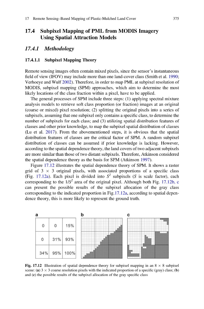
Figure 17.12 illustrates the spatial dependence theory of SPM. It shows a raster
grid of 3 Â 3 original pixels, with associated proportions of a specific class
(Fig. 17.12a). Each pixel is divided into S
2 subpixels (S is scale factor), each
corresponding to the 1/S
2 area of the original pixel. Although both Fig. 17.12b, c
can present the possible results of the subpixel allocation of the gray class
corresponding to the indicated proportion in Fig.17.12a, according to spatial dependence theory, this is more likely to represent the ground truth.
Fig. 17.12 Illustration of spatial dependence theory for subpixel mapping in an 8 Â 8 subpixel
scene: (a) 3 Â 3 coarse resolution pixels with the indicated proportion of a specific (gray) class; (b)
and (c) the possible results of the subpixel allocation of the gray specific class
17 Remote Sensing–Based Mapping of Plastic-Mulched Land Cover
375
Using Spatial Attraction Models
17.4.1 Methodology
17.4.1.1 Subpixel Mapping Theory
Remote sensing images often contain mixed pixels, since the sensor’s instantaneous
field of view (IFOV) may include more than one land-cover class (Smith et al. 1990;
Verhoeye and Wulf 2002). Therefore, in order to map PML at subpixel resolution of
MODIS, subpixel mapping (SPM) approaches, which aim to determine the most
likely locations of the class fraction within a pixel, have to be applied.
The general processes of SPM include three steps: (1) applying spectral mixture
analysis models to retrieve soft class proportion (or fraction) images at an original
(coarse or mixed) pixel resolution; (2) splitting the original pixels into a series of
subpixels, assuming that one subpixel only contains a specific class, to determine the
number of subpixels for each class; and (3) utilizing spatial distribution features of
classes and other prior knowledge, to map the subpixel spatial distribution of classes
(Lu et al. 2017). From the abovementioned steps, it is obvious that the spatial
distribution features of classes are the critical factor of SPM. A random subpixel
distribution of classes can be assumed if prior knowledge is lacking. However,
according to the spatial dependence theory, the land covers of two adjacent subpixels
are more similar than those of two distant subpixels. Therefore, Atkinson considered
the spatial dependence theory as the basis for SPM (Atkinson 1997).
Figure 17.12 illustrates the spatial dependence theory of SPM. It shows a raster
grid of 3 Â 3 original pixels, with associated proportions of a specific class
(Fig. 17.12a). Each pixel is divided into S
2 subpixels (S is scale factor), each
corresponding to the 1/S
2 area of the original pixel. Although both Fig. 17.12b, c
can present the possible results of the subpixel allocation of the gray class
corresponding to the indicated proportion in Fig.17.12a, according to spatial dependence theory, this is more likely to represent the ground truth.
Fig. 17.12 Illustration of spatial dependence theory for subpixel mapping in an 8 Â 8 subpixel
scene: (a) 3 Â 3 coarse resolution pixels with the indicated proportion of a specific (gray) class; (b)
and (c) the possible results of the subpixel allocation of the gray specific class
17 Remote Sensing–Based Mapping of Plastic-Mulched Land Cover
375