

• Normalized Difference Water Index(NDWI)
NDWI is an index that uses the reflected near-infrared and visible green radiations
to delineate open water features and enhance their presence in remotely sensed
digital imagery (McFeeters 1996). NDWI can be calculated as follows:
NDWI ¼ Green À NIR
ð
Þ = Green þ NIR
ð
Þ
ð 17:1Þ
where Green is the surface reflectance in the green band (band 2 in this study) and
NIR is the surface reflectance in the near-infrared band (band 4 in this study). In this
study, the normalized radiance is used to approximate the surface reflectance.
The eight typical landcover types in May 2011
b
The eight typical landcover types in May 2007
c
d
a
The eight typical landcover types in May 1998
PML1 and PML2 in May 2011, 2007 and 1998 respectively
0
0.1
0.2
0.3
0.4
0.5
0.6
0.7
0.8
B1
B2
B3
B4
B5
B7
Band Number
L/L max
PML1
PML2
Bare Land
1
Bare Land
2
Fallow
Land
Saline Land
Vegetation
Cover
Water Body
0
0.1
0.2
0.3
0.4
0.5
0.6
0.7
0.8
B1 B2 B3 B4 B5 B7
Band Number
L/L max
PML1
PML2
Bare Land1
Bare Land2
Fallow
Land
Saline Land
Vegetation
Cover
Water Body
0
0.1
0.2
0.3
0.4
0.5
0.6
0.7
0.8
B1
B2
B3
B4
B5
B7
Band Number
L/L max
PML1
PML2
Bare Land1
Bare Land2
Fallow Land
Saline Land
Vegetation
Cover
Water Body
0
0.1
0.2
0.3
0.4
0.5
0.6
0.7
0.8
B1
B2
B3
B4
B5
B6
Band Number
L/L max
2011
PML1
2011
PML2
2005
PML1
2005
PML2
1998
PML1
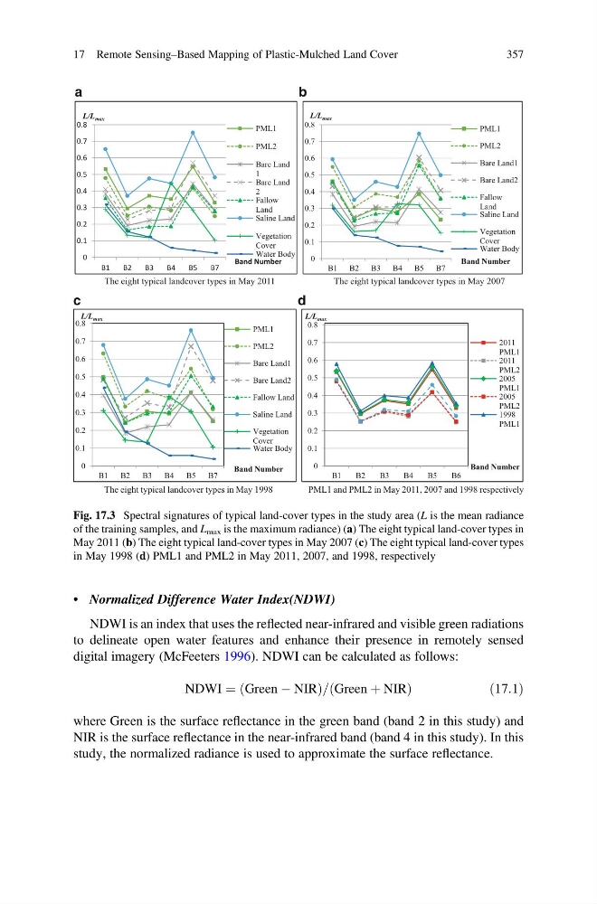
Fig. 17.3 Spectral signatures of typical land-cover types in the study area (L is the mean radiance
of the training samples, and L max is the maximum radiance) (a) The eight typical land-cover types in
May 2011 (b) The eight typical land-cover types in May 2007 (c) The eight typical land-cover types
in May 1998 (d) PML1 and PML2 in May 2011, 2007, and 1998, respectively
17 Remote Sensing–Based Mapping of Plastic-Mulched Land Cover
357
NDWI is an index that uses the reflected near-infrared and visible green radiations
to delineate open water features and enhance their presence in remotely sensed
digital imagery (McFeeters 1996). NDWI can be calculated as follows:
NDWI ¼ Green À NIR
ð
Þ = Green þ NIR
ð
Þ
ð 17:1Þ
where Green is the surface reflectance in the green band (band 2 in this study) and
NIR is the surface reflectance in the near-infrared band (band 4 in this study). In this
study, the normalized radiance is used to approximate the surface reflectance.
The eight typical landcover types in May 2011
b
The eight typical landcover types in May 2007
c
d
a
The eight typical landcover types in May 1998
PML1 and PML2 in May 2011, 2007 and 1998 respectively
0
0.1
0.2
0.3
0.4
0.5
0.6
0.7
0.8
B1
B2
B3
B4
B5
B7
Band Number
L/L max
PML1
PML2
Bare Land
1
Bare Land
2
Fallow
Land
Saline Land
Vegetation
Cover
Water Body
0
0.1
0.2
0.3
0.4
0.5
0.6
0.7
0.8
B1 B2 B3 B4 B5 B7
Band Number
L/L max
PML1
PML2
Bare Land1
Bare Land2
Fallow
Land
Saline Land
Vegetation
Cover
Water Body
0
0.1
0.2
0.3
0.4
0.5
0.6
0.7
0.8
B1
B2
B3
B4
B5
B7
Band Number
L/L max
PML1
PML2
Bare Land1
Bare Land2
Fallow Land
Saline Land
Vegetation
Cover
Water Body
0
0.1
0.2
0.3
0.4
0.5
0.6
0.7
0.8
B1
B2
B3
B4
B5
B6
Band Number
L/L max
2011
PML1
2011
PML2
2005
PML1
2005
PML2
1998
PML1
Fig. 17.3 Spectral signatures of typical land-cover types in the study area (L is the mean radiance
of the training samples, and L max is the maximum radiance) (a) The eight typical land-cover types in
May 2011 (b) The eight typical land-cover types in May 2007 (c) The eight typical land-cover types
in May 1998 (d) PML1 and PML2 in May 2011, 2007, and 1998, respectively
17 Remote Sensing–Based Mapping of Plastic-Mulched Land Cover
357