

16.4.3 Study Area
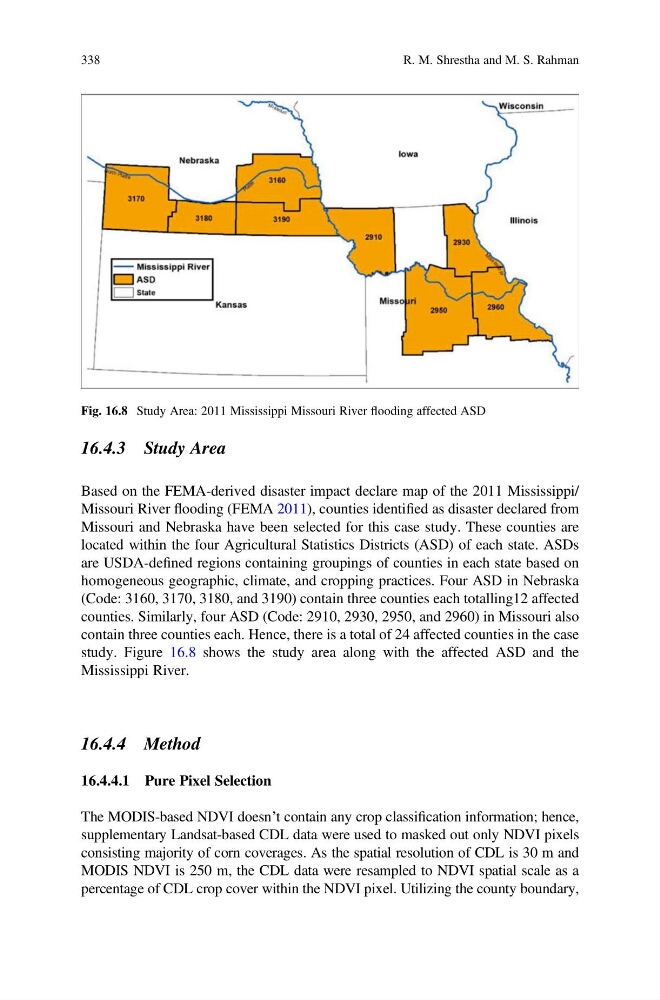
Based on the FEMA-derived disaster impact declare map of the 2011 Mississippi/
Missouri River flooding (FEMA 2011), counties identified as disaster declared from
Missouri and Nebraska have been selected for this case study. These counties are
located within the four Agricultural Statistics Districts (ASD) of each state. ASDs
are USDA-defined regions containing groupings of counties in each state based on
homogeneous geographic, climate, and cropping practices. Four ASD in Nebraska
(Code: 3160, 3170, 3180, and 3190) contain three counties each totalling12 affected
counties. Similarly, four ASD (Code: 2910, 2930, 2950, and 2960) in Missouri also
contain three counties each. Hence, there is a total of 24 affected counties in the case
study. Figure 16.8 shows the study area along with the affected ASD and the
Mississippi River.
16.4.4 Method
16.4.4.1 Pure Pixel Selection
The MODIS-based NDVI doesn’t contain any crop classification information; hence,
supplementary Landsat-based CDL data were used to masked out only NDVI pixels
consisting majority of corn coverages. As the spatial resolution of CDL is 30 m and
MODIS NDVI is 250 m, the CDL data were resampled to NDVI spatial scale as a
percentage of CDL crop cover within the NDVI pixel. Utilizing the county boundary,
Fig. 16.8 Study Area: 2011 Mississippi Missouri River flooding affected ASD
338
R. M. Shrestha and M. S. Rahman
Based on the FEMA-derived disaster impact declare map of the 2011 Mississippi/
Missouri River flooding (FEMA 2011), counties identified as disaster declared from
Missouri and Nebraska have been selected for this case study. These counties are
located within the four Agricultural Statistics Districts (ASD) of each state. ASDs
are USDA-defined regions containing groupings of counties in each state based on
homogeneous geographic, climate, and cropping practices. Four ASD in Nebraska
(Code: 3160, 3170, 3180, and 3190) contain three counties each totalling12 affected
counties. Similarly, four ASD (Code: 2910, 2930, 2950, and 2960) in Missouri also
contain three counties each. Hence, there is a total of 24 affected counties in the case
study. Figure 16.8 shows the study area along with the affected ASD and the
Mississippi River.
16.4.4 Method
16.4.4.1 Pure Pixel Selection
The MODIS-based NDVI doesn’t contain any crop classification information; hence,
supplementary Landsat-based CDL data were used to masked out only NDVI pixels
consisting majority of corn coverages. As the spatial resolution of CDL is 30 m and
MODIS NDVI is 250 m, the CDL data were resampled to NDVI spatial scale as a
percentage of CDL crop cover within the NDVI pixel. Utilizing the county boundary,
Fig. 16.8 Study Area: 2011 Mississippi Missouri River flooding affected ASD
338
R. M. Shrestha and M. S. Rahman