

16.3 Flood Crop Damage Assessments
This section will highlight two methods: classification and band ratioing for flood
damage assessment using passive remote sensing applications.
16.3.1 Classification Method
Classification in remote sensing is a process of redefining each pixel (or group of
pixels) within an image/scene, based on its thematic properties, into a specific land
cover type. Pixels within similar land cover such as forest, urban, agriculture, etc.
tend to exhibit similar reflectance properties (spectral signature), and by accurately
identifying and grouping them into a defined class, the entire image can be classified
into sets of predefined land-cover types. The classification methods can be carried
out with two basic approaches: supervised and unsupervised (Thomas et al. 2003).
The supervised classification method requires sets of end members within the image,
which is also known as ground truth data. Based on the total number of final landcover types to be classified, end member pixels are selected from the same image for
each land cover based on either prior knowledge of the area or some supplementary
information such as high-resolution aerial photography or survey data. Once these
groups of end members are selected, a defined classification algorithm will classify
each pixel within the image into one of the defined end member classes based on
similar spectral signature or reflectance characteristics. The unsupervised classification also uses a similar classification algorithm to select each pixel into defined land
cover types; however, unlike the supervised version of the classification, the userdefined sample classes as end members are not provided. Based on the classification
algorithm, the computer model automatically groups pixels with similar spectral
properties into the desired group of classes. For accurate classification, users must
have prior knowledge of the area to relate the computer-generated grouping of pixels
with the actual desire land cover.
The idea of utilizing image classification methods on flood crop damage assessment is to compare and contrast multi-temporal scenes within the same geographic
location for any changes. The total damage assessment will be solely based on the
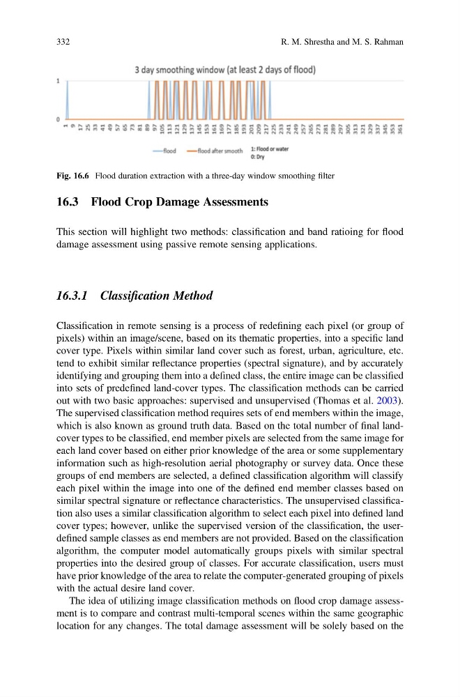
Fig. 16.6 Flood duration extraction with a three-day window smoothing filter
332
R. M. Shrestha and M. S. Rahman
This section will highlight two methods: classification and band ratioing for flood
damage assessment using passive remote sensing applications.
16.3.1 Classification Method
Classification in remote sensing is a process of redefining each pixel (or group of
pixels) within an image/scene, based on its thematic properties, into a specific land
cover type. Pixels within similar land cover such as forest, urban, agriculture, etc.
tend to exhibit similar reflectance properties (spectral signature), and by accurately
identifying and grouping them into a defined class, the entire image can be classified
into sets of predefined land-cover types. The classification methods can be carried
out with two basic approaches: supervised and unsupervised (Thomas et al. 2003).
The supervised classification method requires sets of end members within the image,
which is also known as ground truth data. Based on the total number of final landcover types to be classified, end member pixels are selected from the same image for
each land cover based on either prior knowledge of the area or some supplementary
information such as high-resolution aerial photography or survey data. Once these
groups of end members are selected, a defined classification algorithm will classify
each pixel within the image into one of the defined end member classes based on
similar spectral signature or reflectance characteristics. The unsupervised classification also uses a similar classification algorithm to select each pixel into defined land
cover types; however, unlike the supervised version of the classification, the userdefined sample classes as end members are not provided. Based on the classification
algorithm, the computer model automatically groups pixels with similar spectral
properties into the desired group of classes. For accurate classification, users must
have prior knowledge of the area to relate the computer-generated grouping of pixels
with the actual desire land cover.
The idea of utilizing image classification methods on flood crop damage assessment is to compare and contrast multi-temporal scenes within the same geographic
location for any changes. The total damage assessment will be solely based on the
Fig. 16.6 Flood duration extraction with a three-day window smoothing filter
332
R. M. Shrestha and M. S. Rahman