

was demonstrated that a benchmark product can be generated by merging satellite
estimates with the LSM outputs. However, due to no direct estimation of ET and
drought conditions from satellites, it was displayed that the trapezoid model and
satellite-derived vegetation greenness along with the VCI method can be employed
to accurately estimate ET through EF and track agricultural drought from space,
respectively.
References
Allen, R. G., Pereira, L. S., Raes, D., & Smith, M. (1998). Crop evapotranspiration: Guidelines for
computing crop water requirements (Irrigation and drainage paper 56). Rome: FAO – Food and
Agriculture Organization of the United Nations. http://www.kimberly.uidaho.edu/water/fao56/
fao56.pdf.
Allen, R., Irmak, A., Trezza, R., Jan, M., Hendrickx, H., Bastiaanssen, W., & Kjaersgaard,
J. (2011). Satellite-based ET estimation in agriculture using SEBAL and METRIC. Hydrological Processes, 25(26), 4011–4027. https://doi.org/10.1002/hyp.8408.
Anderson, M. C., & Kustas, W. (2008). Thermal remote sensing of drought and evapotranspiration.
Eos, Transactions American Geophysical Union, 89(26), 233. https://doi.org/10.1029/
2008EO260001.
Anderson, W. B., Zaitchik, B. F., Hain, C. R., Anderson, M. C., Tugrul Yilmaz, M., Mecikalski, J.,
& Schultz, L. (2012). Towards an integrated soil moisture drought monitor for East Africa.
Hydrology and Earth System Sciences, 16(8), 2893–2913. https://doi.org/10.5194/hess-162893-2012.
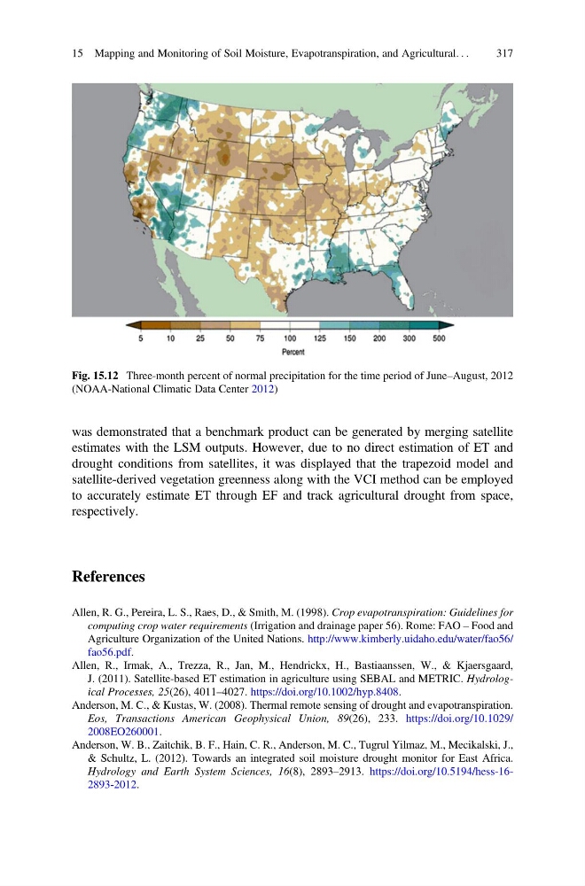
Fig. 15.12 Three-month percent of normal precipitation for the time period of June–August, 2012
(NOAA-National Climatic Data Center 2012)
15 Mapping and Monitoring of Soil Moisture, Evapotranspiration, and Agricultural. . .
317
estimates with the LSM outputs. However, due to no direct estimation of ET and
drought conditions from satellites, it was displayed that the trapezoid model and
satellite-derived vegetation greenness along with the VCI method can be employed
to accurately estimate ET through EF and track agricultural drought from space,
respectively.
References
Allen, R. G., Pereira, L. S., Raes, D., & Smith, M. (1998). Crop evapotranspiration: Guidelines for
computing crop water requirements (Irrigation and drainage paper 56). Rome: FAO – Food and
Agriculture Organization of the United Nations. http://www.kimberly.uidaho.edu/water/fao56/
fao56.pdf.
Allen, R., Irmak, A., Trezza, R., Jan, M., Hendrickx, H., Bastiaanssen, W., & Kjaersgaard,
J. (2011). Satellite-based ET estimation in agriculture using SEBAL and METRIC. Hydrological Processes, 25(26), 4011–4027. https://doi.org/10.1002/hyp.8408.
Anderson, M. C., & Kustas, W. (2008). Thermal remote sensing of drought and evapotranspiration.
Eos, Transactions American Geophysical Union, 89(26), 233. https://doi.org/10.1029/
2008EO260001.
Anderson, W. B., Zaitchik, B. F., Hain, C. R., Anderson, M. C., Tugrul Yilmaz, M., Mecikalski, J.,
& Schultz, L. (2012). Towards an integrated soil moisture drought monitor for East Africa.
Hydrology and Earth System Sciences, 16(8), 2893–2913. https://doi.org/10.5194/hess-162893-2012.
Fig. 15.12 Three-month percent of normal precipitation for the time period of June–August, 2012
(NOAA-National Climatic Data Center 2012)
15 Mapping and Monitoring of Soil Moisture, Evapotranspiration, and Agricultural. . .
317