

growing season (June, July, and August) is used for visual crop or cultivated land
identification (USGS 2017a). National Agricultural Imagery Program (NAIP) aerial
photography, one-meter aerial imagery acquired by the USDA Farm Service
Agency, is also used for visual identification of crops. The most recent acquisitions
of the NAIP data are used for editing PSU boundaries (USDA FSA 2017a). United
States Geological Survey’s 7.5-minute series quadrangles (1:24,000 scale) and
(1:100,000 scale) topographic maps provide information regarding the location of
streams, roads, section lines, park boundaries, etc. These topographic maps are used
to confirm PSU boundaries. (USGS 2017b). USDA Farm Service Agency’s Common Land Unit data are standardized Geographic Information Systems data layers,
which capture agricultural information about the nation’s farms and fields that are
established to support farm commodity and conservation programs. Common Land
Unit data are individual contiguous farming parcels that are updated every growing
season when farmers report crop type and acreage for their fields to over 2300 Farm
Service Agency county offices. The Farm Service Agency Common Land Unit data
are used to spot check and confirm areas under cultivation (USDA FSA 2017b;
Heald 2002). US Census Block data are used to identify population centers
(U. S. Census Bureau 2017). State-specific ancillary data sets are also used to
identify and confirm population centers. State Geographic Information Systems
layers, Bing Maps (Bing Maps 2017), and Google Earth “street view” data (Google
2017) are used to identify and confirm PSU boundaries (roads, fences).
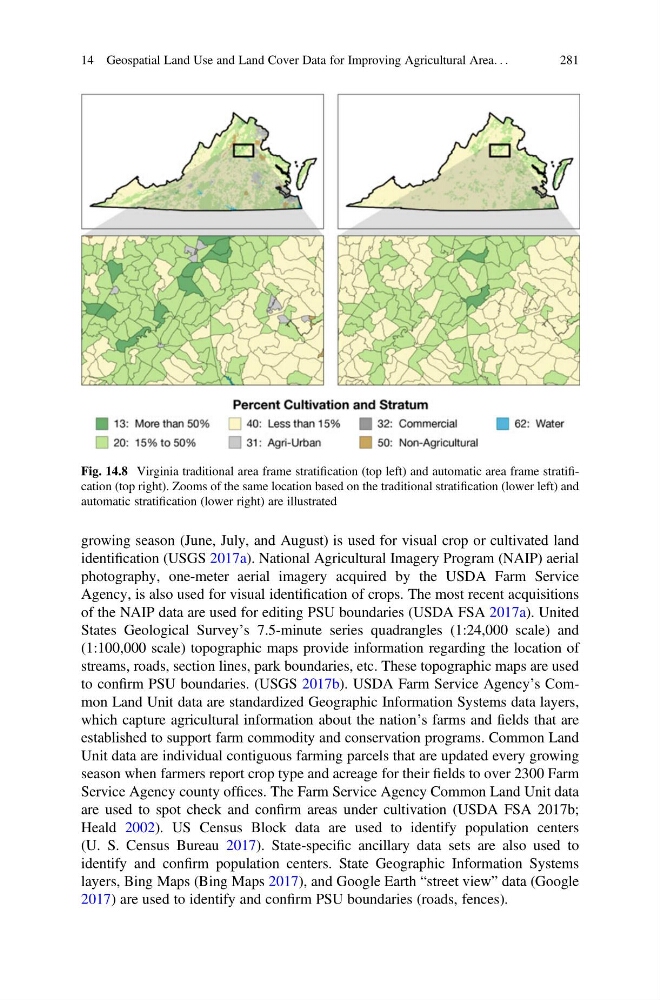
Fig. 14.8 Virginia traditional area frame stratification (top left) and automatic area frame stratification (top right). Zooms of the same location based on the traditional stratification (lower left) and
automatic stratification (lower right) are illustrated
14 Geospatial Land Use and Land Cover Data for Improving Agricultural Area. . .
281
identification (USGS 2017a). National Agricultural Imagery Program (NAIP) aerial
photography, one-meter aerial imagery acquired by the USDA Farm Service
Agency, is also used for visual identification of crops. The most recent acquisitions
of the NAIP data are used for editing PSU boundaries (USDA FSA 2017a). United
States Geological Survey’s 7.5-minute series quadrangles (1:24,000 scale) and
(1:100,000 scale) topographic maps provide information regarding the location of
streams, roads, section lines, park boundaries, etc. These topographic maps are used
to confirm PSU boundaries. (USGS 2017b). USDA Farm Service Agency’s Common Land Unit data are standardized Geographic Information Systems data layers,
which capture agricultural information about the nation’s farms and fields that are
established to support farm commodity and conservation programs. Common Land
Unit data are individual contiguous farming parcels that are updated every growing
season when farmers report crop type and acreage for their fields to over 2300 Farm
Service Agency county offices. The Farm Service Agency Common Land Unit data
are used to spot check and confirm areas under cultivation (USDA FSA 2017b;
Heald 2002). US Census Block data are used to identify population centers
(U. S. Census Bureau 2017). State-specific ancillary data sets are also used to
identify and confirm population centers. State Geographic Information Systems
layers, Bing Maps (Bing Maps 2017), and Google Earth “street view” data (Google
2017) are used to identify and confirm PSU boundaries (roads, fences).
Fig. 14.8 Virginia traditional area frame stratification (top left) and automatic area frame stratification (top right). Zooms of the same location based on the traditional stratification (lower left) and
automatic stratification (lower right) are illustrated
14 Geospatial Land Use and Land Cover Data for Improving Agricultural Area. . .
281