

Non-agriculture blocks can exceptionally be split arbitrarily to avoid huge polygons; in particular, roads should be divided to avoid complex, large, linear polygons.
Physical blocks should normally be homogeneous, containing a single land class.
However, in exceptional circumstances and to avoid unnecessary digitization of
small PBs, a physical block can contain inclusions of the land of a different
agricultural class within its boundary, where this is not more than 10% of the
whole and where these inclusions cannot easily be separated. Examples might
include small areas of grassland within an area of permanent tree crops, small
areas of grassland within an arable area, small greenhouses (arable land) within an
area of permanent tree crops, and small areas of arable land within grassland,
especially in the hills.
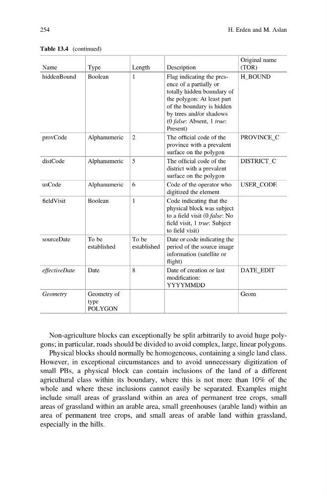
Table 13.4 (continued)
Name
Type
Length
Description
Original name
(TOR)
hiddenBound
Boolean
1
Flag indicating the presence of a partially or
totally hidden boundary of
the polygon: At least part
of the boundary is hidden
by trees and/or shadows
(0 false: Absent, 1 true:
Present)
H_BOUND
provCode
Alphanumeric 2
The official code of the
province with a prevalent
surface on the polygon
PROVINCE_C
distCode
Alphanumeric 5
The official code of the
district with a prevalent
surface on the polygon
DISTRICT_C
usCode
Alphanumeric 6
Code of the operator who
digitized the element
USER_CODE
fieldVisit
Boolean
1
Code indicating that the
physical block was subject
to a field visit (0 false: No
field visit, 1 true: Subject
to field visit)
sourceDate
To be
established
To be
established
Date or code indicating the
period of the source image
information (satellite or
flight)
effectiveDate
Date
8
Date of creation or last
modification:
YYYYMMDD
DATE_EDIT
Geometry
Geometry of
type
POLYGON
Geom
254
H. Erden and M. Aslan
Physical blocks should normally be homogeneous, containing a single land class.
However, in exceptional circumstances and to avoid unnecessary digitization of
small PBs, a physical block can contain inclusions of the land of a different
agricultural class within its boundary, where this is not more than 10% of the
whole and where these inclusions cannot easily be separated. Examples might
include small areas of grassland within an area of permanent tree crops, small
areas of grassland within an arable area, small greenhouses (arable land) within an
area of permanent tree crops, and small areas of arable land within grassland,
especially in the hills.
Table 13.4 (continued)
Name
Type
Length
Description
Original name
(TOR)
hiddenBound
Boolean
1
Flag indicating the presence of a partially or
totally hidden boundary of
the polygon: At least part
of the boundary is hidden
by trees and/or shadows
(0 false: Absent, 1 true:
Present)
H_BOUND
provCode
Alphanumeric 2
The official code of the
province with a prevalent
surface on the polygon
PROVINCE_C
distCode
Alphanumeric 5
The official code of the
district with a prevalent
surface on the polygon
DISTRICT_C
usCode
Alphanumeric 6
Code of the operator who
digitized the element
USER_CODE
fieldVisit
Boolean
1
Code indicating that the
physical block was subject
to a field visit (0 false: No
field visit, 1 true: Subject
to field visit)
sourceDate
To be
established
To be
established
Date or code indicating the
period of the source image
information (satellite or
flight)
effectiveDate
Date
8
Date of creation or last
modification:
YYYYMMDD
DATE_EDIT
Geometry
Geometry of
type
POLYGON
Geom
254
H. Erden and M. Aslan