

is accessible through most browsers, such as Google Chrome, Internet Explorer,
Firefox, and Safari; the users can access and analyze on-demand data and information without installing additional software or plug-in in the browser. In addition,
VegScape provides on-demand crop condition index retrieving and processing
automation; automatic data publishing and dissemination, irregular ad-hoc data
processing for emergency assessment or reporting, objective historical data comparison for vegetation condition assessment, various vegetation condition metrics, and
specific crop monitoring.
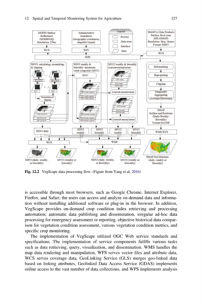
The implementation of VegScape utilized OGC Web service standards and
specifications. The implementation of service components fulfills various tasks
such as data retrieving, query, visualization, and dissemination. WMS handles the
map data rendering and manipulation, WFS serves vector files and attribute data,
WCS serves coverage data, GeoLinking Service (GLS) merges geo-linked data
based on linking attributes, Geolinked Data Access Service (GDAS) implements
online access to the vast number of data collections, and WPS implements analysis
Fig. 12.2 VegScape data processing flow. (Figure from Yang et al. 2016)
12 Spatial and Temporal Monitoring System for Agriculture
227
Firefox, and Safari; the users can access and analyze on-demand data and information without installing additional software or plug-in in the browser. In addition,
VegScape provides on-demand crop condition index retrieving and processing
automation; automatic data publishing and dissemination, irregular ad-hoc data
processing for emergency assessment or reporting, objective historical data comparison for vegetation condition assessment, various vegetation condition metrics, and
specific crop monitoring.
The implementation of VegScape utilized OGC Web service standards and
specifications. The implementation of service components fulfills various tasks
such as data retrieving, query, visualization, and dissemination. WMS handles the
map data rendering and manipulation, WFS serves vector files and attribute data,
WCS serves coverage data, GeoLinking Service (GLS) merges geo-linked data
based on linking attributes, Geolinked Data Access Service (GDAS) implements
online access to the vast number of data collections, and WPS implements analysis
Fig. 12.2 VegScape data processing flow. (Figure from Yang et al. 2016)
12 Spatial and Temporal Monitoring System for Agriculture
227