

but not listed as one of the top priorities, and a rough information of ownership was
enough. Starting with the Industrial Revolution, land parcel information is required
to be accurately measured due to the development of road, railroad, and constructions (Kain and Baigent 1992; Williamson and Ting 2001). Benefiting from the
popularity of desktop computers, many land parcel data were transferred to digital.
The National Research Council (2007) pointed out that one-third counties in the
United States have digital land parcel data available, and many private companies
have built their own electronic land parcel databases. Although these data were
stored digitally, it was not convenient to use digitalized land parcel data since they
were just digitalized images.
The development of remote sensing and geographic information system (GIS)
delivered an alternative way to collect, store, and analyze land parcel data. Remote
sensing as one of latest Earth observation techniques has been deployed into many
land parcel identification studies (Bocco et al. 2001; Oesterle and Hahn 2004).
Remote sensing not only provides an unbiased data source for land parcel identification at low cost, but satellites also provide the ability of continuous monitoring.
GIS was utilized as a key tool in managing land parcel data in research (Kiehle et al.
2007; Moudon 2000).
It is necessary to have land parcel information in agricultural management
systems since all types of agricultural activities are conducted on land. For example,
the input of land parcel data could describe land supply and capacity for agriculture
(Moudon 2000). Land parcel information is required to evaluate and support agricultural sustainability and productivity (Oesterle and Hahn 2004; Zhang et al.
2019b). Better understanding of the condition of the land required reliable land
parcel data as reference and input parameters.
There are few benefits for adding land parcel information in agro-geoinformation
systems. Land parcel is a necessary input in agricultural studies. With the inclusion
of land parcel information (especially for large-scale research), results from agricultural studies will be more reliable. Thus, the reliable result could benefit policy and
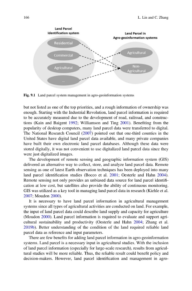
decision-makers. However, land parcel identification and management in agroFig. 9.1 Land parcel system management in agro-geoinformation systems
166
L. Lin and C. Zhang
enough. Starting with the Industrial Revolution, land parcel information is required
to be accurately measured due to the development of road, railroad, and constructions (Kain and Baigent 1992; Williamson and Ting 2001). Benefiting from the
popularity of desktop computers, many land parcel data were transferred to digital.
The National Research Council (2007) pointed out that one-third counties in the
United States have digital land parcel data available, and many private companies
have built their own electronic land parcel databases. Although these data were
stored digitally, it was not convenient to use digitalized land parcel data since they
were just digitalized images.
The development of remote sensing and geographic information system (GIS)
delivered an alternative way to collect, store, and analyze land parcel data. Remote
sensing as one of latest Earth observation techniques has been deployed into many
land parcel identification studies (Bocco et al. 2001; Oesterle and Hahn 2004).
Remote sensing not only provides an unbiased data source for land parcel identification at low cost, but satellites also provide the ability of continuous monitoring.
GIS was utilized as a key tool in managing land parcel data in research (Kiehle et al.
2007; Moudon 2000).
It is necessary to have land parcel information in agricultural management
systems since all types of agricultural activities are conducted on land. For example,
the input of land parcel data could describe land supply and capacity for agriculture
(Moudon 2000). Land parcel information is required to evaluate and support agricultural sustainability and productivity (Oesterle and Hahn 2004; Zhang et al.
2019b). Better understanding of the condition of the land required reliable land
parcel data as reference and input parameters.
There are few benefits for adding land parcel information in agro-geoinformation
systems. Land parcel is a necessary input in agricultural studies. With the inclusion
of land parcel information (especially for large-scale research), results from agricultural studies will be more reliable. Thus, the reliable result could benefit policy and
decision-makers. However, land parcel identification and management in agroFig. 9.1 Land parcel system management in agro-geoinformation systems
166
L. Lin and C. Zhang