

ET 0 , P, and IR are temporal data patterns. NDVI is a spatial data. Another type of
data named synthetic NDVI (SNDVI) derived with respect to the high correlation
between NDVI and the fraction of vegetation cover (FVC) by using the regression
model is shown in Fig. 7.14. FVC is calculated from TARBIL monitoring station
camera images that are acquired at 30-min time intervals. Hence, SNDVI is generated as a spatiotemporal parameter instead of NDVI. Indirectly it fills the time gap
between the two remotely sensed NDVI values.
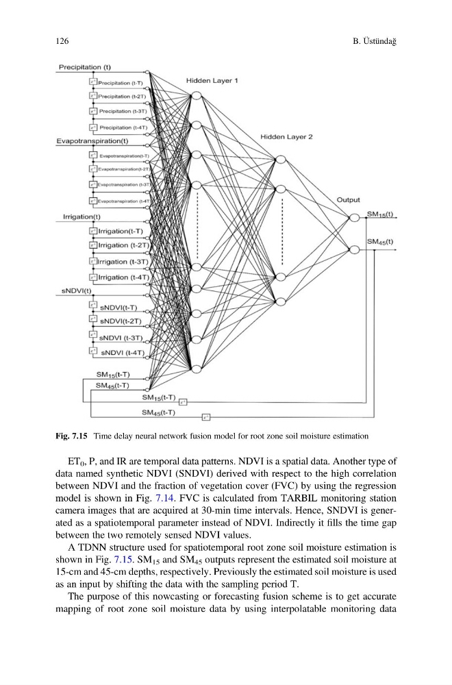
A TDNN structure used for spatiotemporal root zone soil moisture estimation is
shown in Fig. 7.15. SM 15 and SM 45 outputs represent the estimated soil moisture at
15-cm and 45-cm depths, respectively. Previously the estimated soil moisture is used
as an input by shifting the data with the sampling period T.
The purpose of this nowcasting or forecasting fusion scheme is to get accurate
mapping of root zone soil moisture data by using interpolatable monitoring data
Fig. 7.15 Time delay neural network fusion model for root zone soil moisture estimation
126
B. Üstündağ
data named synthetic NDVI (SNDVI) derived with respect to the high correlation
between NDVI and the fraction of vegetation cover (FVC) by using the regression
model is shown in Fig. 7.14. FVC is calculated from TARBIL monitoring station
camera images that are acquired at 30-min time intervals. Hence, SNDVI is generated as a spatiotemporal parameter instead of NDVI. Indirectly it fills the time gap
between the two remotely sensed NDVI values.
A TDNN structure used for spatiotemporal root zone soil moisture estimation is
shown in Fig. 7.15. SM 15 and SM 45 outputs represent the estimated soil moisture at
15-cm and 45-cm depths, respectively. Previously the estimated soil moisture is used
as an input by shifting the data with the sampling period T.
The purpose of this nowcasting or forecasting fusion scheme is to get accurate
mapping of root zone soil moisture data by using interpolatable monitoring data
Fig. 7.15 Time delay neural network fusion model for root zone soil moisture estimation
126
B. Üstündağ