

(a) Spatial data that is equally sampled throughout a specific region at some planned
times.
(b) Multi-temporal data that is equally sampled throughout a specific region within
known periods.
(c) Temporal data that is sampled at any required frequency within measurement
bandwidth but at specific monitoring locations only.
VHR satellite images, aerial orthophotos, and drone-based observations are
spatial data. Agrometeorological and phenological observations from terrestrial
monitoring stations are temporal data. Remote sensing satellites, such as MODIS,
LandSat, or Sentinel, provide multitemporal data by periodic imaging on their orbits.
Although they provide temporal resolution, their spatial resolution is still less than
the VHR satellites. On the other hand, their cost efficiency and different sensor type
availability are high, while spatial resolution is also in rising trend depending on
technological developments. Mission-dedicated low-orbit remote sensing satellites
are able to meet higher-spatial-resolution requirements with less operational life time
than the higher orbit remote sensing satellites.
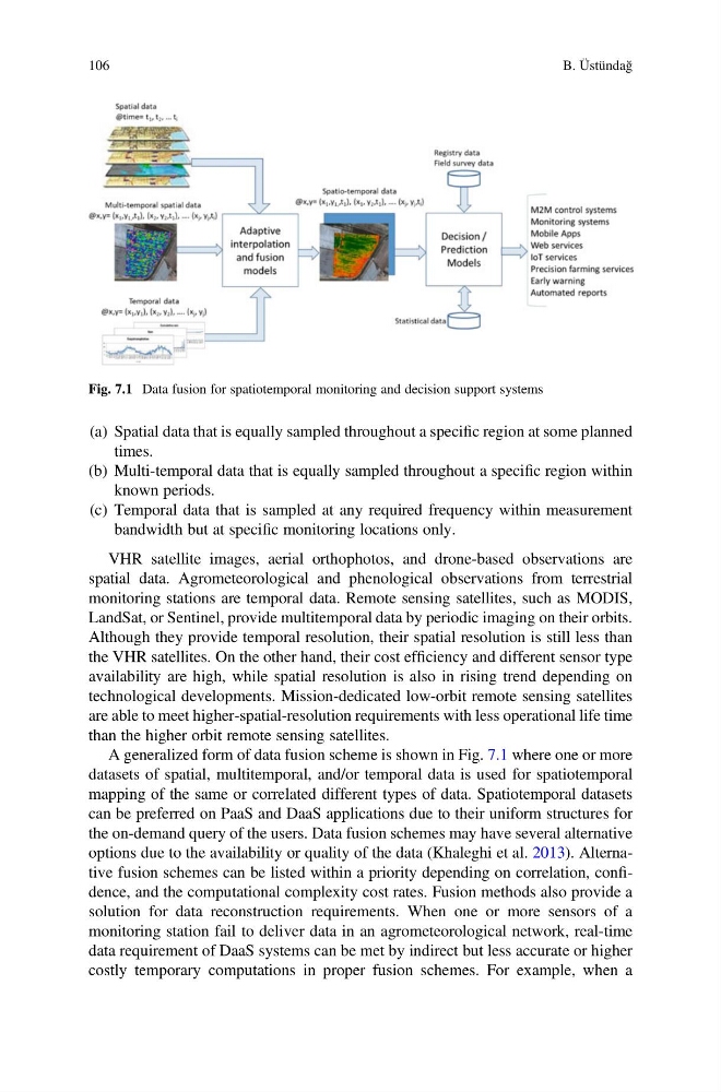
A generalized form of data fusion scheme is shown in Fig. 7.1 where one or more
datasets of spatial, multitemporal, and/or temporal data is used for spatiotemporal
mapping of the same or correlated different types of data. Spatiotemporal datasets
can be preferred on PaaS and DaaS applications due to their uniform structures for
the on-demand query of the users. Data fusion schemes may have several alternative
options due to the availability or quality of the data (Khaleghi et al. 2013). Alternative fusion schemes can be listed within a priority depending on correlation, confidence, and the computational complexity cost rates. Fusion methods also provide a
solution for data reconstruction requirements. When one or more sensors of a
monitoring station fail to deliver data in an agrometeorological network, real-time
data requirement of DaaS systems can be met by indirect but less accurate or higher
costly temporary computations in proper fusion schemes. For example, when a
Fig. 7.1 Data fusion for spatiotemporal monitoring and decision support systems
106
B. Üstündağ
times.
(b) Multi-temporal data that is equally sampled throughout a specific region within
known periods.
(c) Temporal data that is sampled at any required frequency within measurement
bandwidth but at specific monitoring locations only.
VHR satellite images, aerial orthophotos, and drone-based observations are
spatial data. Agrometeorological and phenological observations from terrestrial
monitoring stations are temporal data. Remote sensing satellites, such as MODIS,
LandSat, or Sentinel, provide multitemporal data by periodic imaging on their orbits.
Although they provide temporal resolution, their spatial resolution is still less than
the VHR satellites. On the other hand, their cost efficiency and different sensor type
availability are high, while spatial resolution is also in rising trend depending on
technological developments. Mission-dedicated low-orbit remote sensing satellites
are able to meet higher-spatial-resolution requirements with less operational life time
than the higher orbit remote sensing satellites.
A generalized form of data fusion scheme is shown in Fig. 7.1 where one or more
datasets of spatial, multitemporal, and/or temporal data is used for spatiotemporal
mapping of the same or correlated different types of data. Spatiotemporal datasets
can be preferred on PaaS and DaaS applications due to their uniform structures for
the on-demand query of the users. Data fusion schemes may have several alternative
options due to the availability or quality of the data (Khaleghi et al. 2013). Alternative fusion schemes can be listed within a priority depending on correlation, confidence, and the computational complexity cost rates. Fusion methods also provide a
solution for data reconstruction requirements. When one or more sensors of a
monitoring station fail to deliver data in an agrometeorological network, real-time
data requirement of DaaS systems can be met by indirect but less accurate or higher
costly temporary computations in proper fusion schemes. For example, when a
Fig. 7.1 Data fusion for spatiotemporal monitoring and decision support systems
106
B. Üstündağ