

64
Coastal Engineering: Theory and Practice
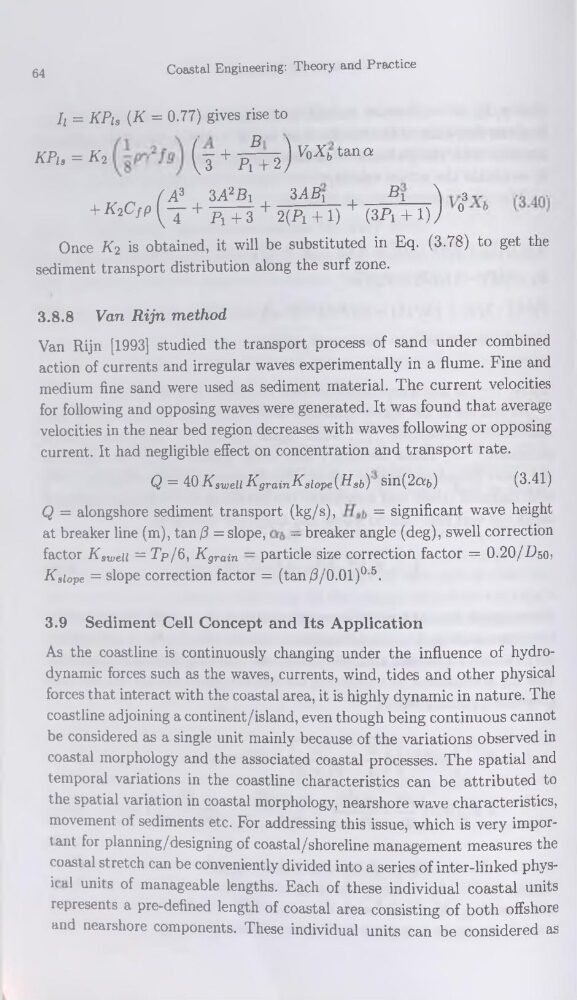
h = KPis {K = 0.77) gives rise to
KPis = K2
(j + ^+2) V°Xbtâna
/ A? 3 A2 Si
3ABr____ B1
\ 3 „
,
.
+Æ2C^(t + K+3 + 2(Pi + i) + (3Pi + i)J 0
Once K2 is obtained, it will be substituted in Eq. (3.78) to get the
sédiment transport distribution along the surf zone.
3.8.8 Van Rijn method
Van Rijn [1993] studied the transport process of sand under combined
action of currents and irregular waves experimentally in a flume. Fine and
medium fine sand were used as sédiment material. The current velocities
for following and opposing waves were generated. It was found that average
velocities in the near bed région decreases with waves following or opposing
current. It had negligible effect on concentration and transport rate.
Q = 40 Ksweii KgrainKgiope (HSb) sin(2o!b)
(3.41)
Q = alongshore sédiment transport (kg/s),
= significant wave height
at breaker line (m), tan (3 = slope,
— breaker angle (deg), swell correction
factor Kaweu = Tp/ü, Kgrain — particle size correction factor = 0.20/7950,
Kslope = slope correction factor = (tan/3/O.Ol)0 5.
3.9 Sédiment Cell Concept and Its Application
As the coastline is continuously changing under the influence of hydrodynamic forces such as the waves, currents, wind, tides and other physical
forces that interact with the Coastal area, it is highly dynamic in nature. The
coastline adjoining a continent/island, even though being continuous cannot
be considered as a single unit mainly because of the variations observed in
Coastal morphology and the associated Coastal processes. The spatial and
temporal variations in the coastline characteristics can be attributed to
the spatial variation in Coastal morphology, nearshore wave characteristics,
movement of sédiments etc. For addressing this issue, which is very important for planning/designing of coastal/shoreline management measures the
Coastal stretch can be conveniently divided into a sériés of inter-linked physi( al units of manageable lengths. Each of these individual coastal units
represents a pre-defined length of coastal area consisting of both offshore
and nearshore components. These individual units can be considered as
Coastal Engineering: Theory and Practice
h = KPis {K = 0.77) gives rise to
KPis = K2
(j + ^+2) V°Xbtâna
/ A? 3 A2 Si
3ABr____ B1
\ 3 „
,
.
+Æ2C^(t + K+3 + 2(Pi + i) + (3Pi + i)J 0
Once K2 is obtained, it will be substituted in Eq. (3.78) to get the
sédiment transport distribution along the surf zone.
3.8.8 Van Rijn method
Van Rijn [1993] studied the transport process of sand under combined
action of currents and irregular waves experimentally in a flume. Fine and
medium fine sand were used as sédiment material. The current velocities
for following and opposing waves were generated. It was found that average
velocities in the near bed région decreases with waves following or opposing
current. It had negligible effect on concentration and transport rate.
Q = 40 Ksweii KgrainKgiope (HSb) sin(2o!b)
(3.41)
Q = alongshore sédiment transport (kg/s),
= significant wave height
at breaker line (m), tan (3 = slope,
— breaker angle (deg), swell correction
factor Kaweu = Tp/ü, Kgrain — particle size correction factor = 0.20/7950,
Kslope = slope correction factor = (tan/3/O.Ol)0 5.
3.9 Sédiment Cell Concept and Its Application
As the coastline is continuously changing under the influence of hydrodynamic forces such as the waves, currents, wind, tides and other physical
forces that interact with the Coastal area, it is highly dynamic in nature. The
coastline adjoining a continent/island, even though being continuous cannot
be considered as a single unit mainly because of the variations observed in
Coastal morphology and the associated Coastal processes. The spatial and
temporal variations in the coastline characteristics can be attributed to
the spatial variation in Coastal morphology, nearshore wave characteristics,
movement of sédiments etc. For addressing this issue, which is very important for planning/designing of coastal/shoreline management measures the
Coastal stretch can be conveniently divided into a sériés of inter-linked physi( al units of manageable lengths. Each of these individual coastal units
represents a pre-defined length of coastal area consisting of both offshore
and nearshore components. These individual units can be considered as