

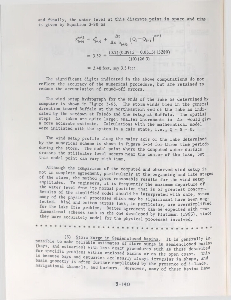
and finally, the water level at this discrète point in space and time
is given by Equation 3-90 as
SW4 “ S"+h +
b
(Qi Qi+1)
3.32
(0.2) (0.0915 ~ 0.0513) (5280)
(10) (26.3)
= 3.48 feet, say 3.5 feet .
The significant digits indicated in the above computations do not
reflect the accuracy of the numerical procedure, but are retained to
reduce the accumulation of round-off errors.
The wind setup hydrograph for the ends of the lake as determined by
computer is shown in Figure 3-63. The storm winds blew in the general
direction toward Buffalo at the northeastem end of the lake as indicated by the setdown at Toledo and the setup at Buffalo. The spatial
steps Ax taken are quite large; smaller incréments in Ax would give
a more accurate estimate. Calculations with the mathematical model
were initiated with the System in a calm State, i.e., Q = S = 0.
The wind setup profile along the major axis of the lake determined
by the numerical scheme is shown in Figure 3-64 for three time periods
during the storm. The nodal point where the computed water surface
crosses the stillwater level occurs near the center of the lake, but
this nodal point can vary with time.
Although the comparison of the computed and observed wind setup is
not in complété agreement, particularly at the beginning and late stages
of the storm, the method gives reasonable results for the wind setup
amplitudes. To engineers, it is frequently the maximum departure of
the water level from its normal position that is of greatest concem.
Results of the simplified model should be interpreted with care, since
many of the physical processes which may be significant hâve been neglected. Wind and bottom stress laws, in particular, are oversimplified
or the Lake Erie problem. Better agreement can be expected with twodimensional schemes such as the one developed by Platzman (1963), since
t ey more accurately model for the physical processes involved.
...
(3) Storm Surge in Semienclosed Basins.
possible to make reliable estimâtes of storm
It is generally im"
lu maxe reiiaoie estimâtes of storm surge in semienclosed basins
ays, an estuaries) with less exact procedures such as those described
ror spécifie problems within enclosed basins or on the open coast. This
oecause bays and estuaries are’nearly always irregular in shape, and
niv-ioa?eOIDeîryu1S Often further complicated by the presence of islands,
lona c annels, and harbors. Moreover, many of these basins hâve
3-140
is given by Equation 3-90 as
SW4 “ S"+h +
b
(Qi Qi+1)
3.32
(0.2) (0.0915 ~ 0.0513) (5280)
(10) (26.3)
= 3.48 feet, say 3.5 feet .
The significant digits indicated in the above computations do not
reflect the accuracy of the numerical procedure, but are retained to
reduce the accumulation of round-off errors.
The wind setup hydrograph for the ends of the lake as determined by
computer is shown in Figure 3-63. The storm winds blew in the general
direction toward Buffalo at the northeastem end of the lake as indicated by the setdown at Toledo and the setup at Buffalo. The spatial
steps Ax taken are quite large; smaller incréments in Ax would give
a more accurate estimate. Calculations with the mathematical model
were initiated with the System in a calm State, i.e., Q = S = 0.
The wind setup profile along the major axis of the lake determined
by the numerical scheme is shown in Figure 3-64 for three time periods
during the storm. The nodal point where the computed water surface
crosses the stillwater level occurs near the center of the lake, but
this nodal point can vary with time.
Although the comparison of the computed and observed wind setup is
not in complété agreement, particularly at the beginning and late stages
of the storm, the method gives reasonable results for the wind setup
amplitudes. To engineers, it is frequently the maximum departure of
the water level from its normal position that is of greatest concem.
Results of the simplified model should be interpreted with care, since
many of the physical processes which may be significant hâve been neglected. Wind and bottom stress laws, in particular, are oversimplified
or the Lake Erie problem. Better agreement can be expected with twodimensional schemes such as the one developed by Platzman (1963), since
t ey more accurately model for the physical processes involved.
...
(3) Storm Surge in Semienclosed Basins.
possible to make reliable estimâtes of storm
It is generally im"
lu maxe reiiaoie estimâtes of storm surge in semienclosed basins
ays, an estuaries) with less exact procedures such as those described
ror spécifie problems within enclosed basins or on the open coast. This
oecause bays and estuaries are’nearly always irregular in shape, and
niv-ioa?eOIDeîryu1S Often further complicated by the presence of islands,
lona c annels, and harbors. Moreover, many of these basins hâve
3-140