

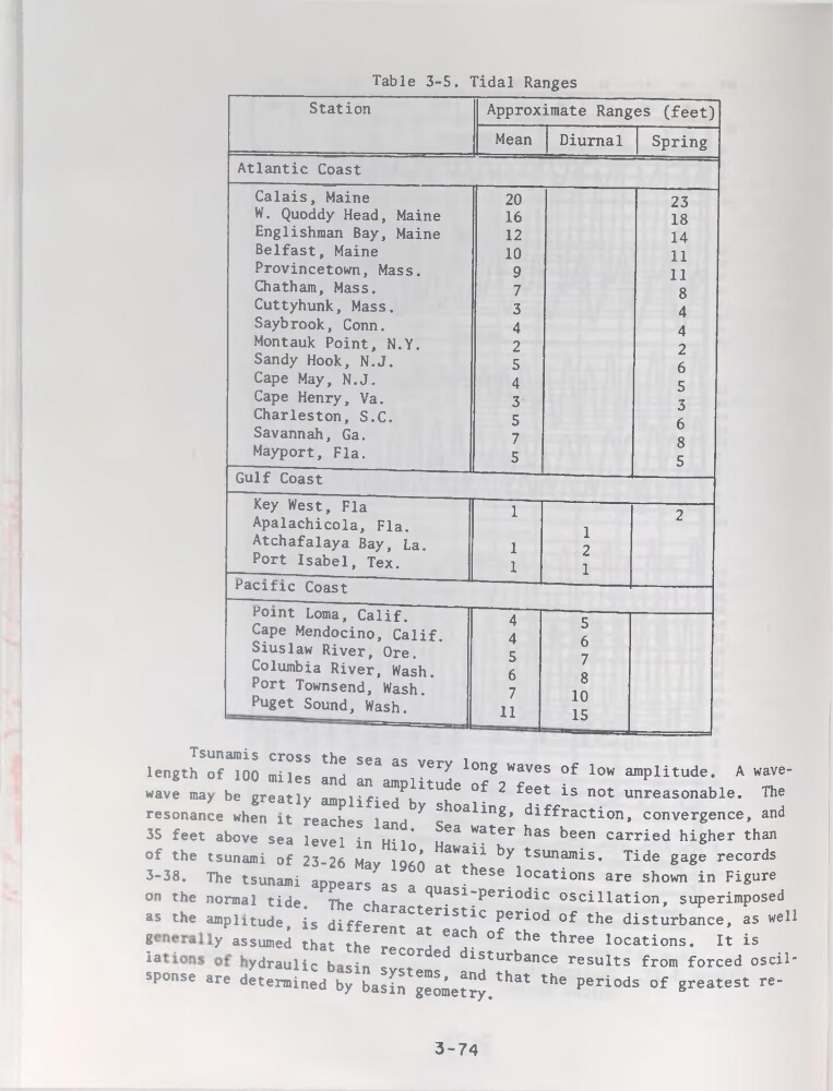
Table 3-5. Tidal Ranges
Station
Approximate Ranges (feet)
Mean
Diurnal
Spring
Atlantic Coast
Calais, Maine
W. Quoddy Head, Maine
Englishman Bay, Maine
Belfast, Maine
Provincetown, Mass.
Chatham, Mass.
Cuttyhunk, Mass.
Saybrook, Conn.
Montauk Point, N.Y.
Sandy Hook, N.J.
Cape May, N.J.
Cape Henry, Va.
Charleston, S.C.
Savannah, Ga.
Mayport, Fia.
20
16
12
10
9
7
3
4
2
5
4
3
5
7
5
23
18
14
11
11
8
4
4
2
6
5
3
6
8
5
Gulf Coast
J
Key West, Fia
Apalachicola, Fia.
Atchafalaya Bay, La.
Port Isabel, Tex.
1
1
1
1
2
1
2
Pacific Coast
Point Loma, Calif.
Cape Mendocino, Calif.
Siuslaw River, Ore.
Columbia River, Wash.
Port Townsend, Wash.
Puget Sound, Wash.
4
4
5
6
7
11
5
6
7
8
10
15
of the
3-38.
Tsunamis cross the sea as very long waves of low amplitude. A wavelength of 100 miles and an amplitude of 2 feet is not unreasonable. The
wave may be greatly amplified by shoaling, diffraction, convergence, and
résonance when it reaches land. Sea water has been carried higher than
35 feet above sea level in Hilo, Hawaii by tsunamis. Tide gage records
tsunami of 25-26 May I960 at these locations are shown in Figure
The tsunami appears as a quasi-periodic oscillation, superimposed
on the normal tide. The characteristic period of the disturbance, as well
as the amplitude, is different at each of the three locations. It is
? .
y assumed that the recorded disturbance results from forced oscil"
4°-- d£X?b^XZ;e^.that the periods of greatest re’
3-74
Station
Approximate Ranges (feet)
Mean
Diurnal
Spring
Atlantic Coast
Calais, Maine
W. Quoddy Head, Maine
Englishman Bay, Maine
Belfast, Maine
Provincetown, Mass.
Chatham, Mass.
Cuttyhunk, Mass.
Saybrook, Conn.
Montauk Point, N.Y.
Sandy Hook, N.J.
Cape May, N.J.
Cape Henry, Va.
Charleston, S.C.
Savannah, Ga.
Mayport, Fia.
20
16
12
10
9
7
3
4
2
5
4
3
5
7
5
23
18
14
11
11
8
4
4
2
6
5
3
6
8
5
Gulf Coast
J
Key West, Fia
Apalachicola, Fia.
Atchafalaya Bay, La.
Port Isabel, Tex.
1
1
1
1
2
1
2
Pacific Coast
Point Loma, Calif.
Cape Mendocino, Calif.
Siuslaw River, Ore.
Columbia River, Wash.
Port Townsend, Wash.
Puget Sound, Wash.
4
4
5
6
7
11
5
6
7
8
10
15
of the
3-38.
Tsunamis cross the sea as very long waves of low amplitude. A wavelength of 100 miles and an amplitude of 2 feet is not unreasonable. The
wave may be greatly amplified by shoaling, diffraction, convergence, and
résonance when it reaches land. Sea water has been carried higher than
35 feet above sea level in Hilo, Hawaii by tsunamis. Tide gage records
tsunami of 25-26 May I960 at these locations are shown in Figure
The tsunami appears as a quasi-periodic oscillation, superimposed
on the normal tide. The characteristic period of the disturbance, as well
as the amplitude, is different at each of the three locations. It is
? .
y assumed that the recorded disturbance results from forced oscil"
4°-- d£X?b^XZ;e^.that the periods of greatest re’
3-74