

37
Descriptive Oceanography
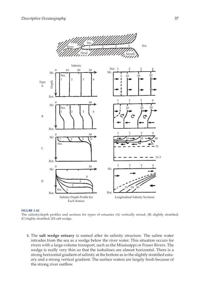
4. The salt wedge estuary is named after its salinity structure. The saline water
intrudes from the sea as a wedge below the river water. This situation occurs for
rivers with a large- volume transport, such as the Mississippi or Fraser Rivers. The
wedge is really very thin so that the isohalines are almost horizontal. There is a
strong horizontal gradient of salinity at the bottom as in the slightly stratified estuary and a strong vertical gradient. The surface waters are largely fresh because of
the strong river outflow.
0
Sfc.
Stn.
1
2
3
4
Bot.
Type
A
Depth
10
20
Salinity
River
Stn.
1
2
3
4
Sea
Mouth
Head
Salinity/Depth Profile for
Each Station
Longitudinal Salinity Sections
30
0
Sfc.
Stn.
1
2
3
4
Bot.
B
30
0
Sfc.
Stn.
1
2
3
4
Bot.
C
30
0
Sfc.
Stn. 1
2
3
4
Bot.
D
30
Sfc.
Stn: 1
2
3
4
20
10
5
30
1
2
3
4
20
10
5
30
1
2
3
4
20
10
30
31
31.5
1
Sfc.
Bot.
2
3
4
10
5
20 30
Figure 1.42
The salinity/depth profiles and sections for types of estuaries (A) vertically mixed; (B) slightly stratified;
(C) highly stratified; (D) salt wedge.
Descriptive Oceanography
4. The salt wedge estuary is named after its salinity structure. The saline water
intrudes from the sea as a wedge below the river water. This situation occurs for
rivers with a large- volume transport, such as the Mississippi or Fraser Rivers. The
wedge is really very thin so that the isohalines are almost horizontal. There is a
strong horizontal gradient of salinity at the bottom as in the slightly stratified estuary and a strong vertical gradient. The surface waters are largely fresh because of
the strong river outflow.
0
Sfc.
Stn.
1
2
3
4
Bot.
Type
A
Depth
10
20
Salinity
River
Stn.
1
2
3
4
Sea
Mouth
Head
Salinity/Depth Profile for
Each Station
Longitudinal Salinity Sections
30
0
Sfc.
Stn.
1
2
3
4
Bot.
B
30
0
Sfc.
Stn.
1
2
3
4
Bot.
C
30
0
Sfc.
Stn. 1
2
3
4
Bot.
D
30
Sfc.
Stn: 1
2
3
4
20
10
5
30
1
2
3
4
20
10
5
30
1
2
3
4
20
10
30
31
31.5
1
Sfc.
Bot.
2
3
4
10
5
20 30
Figure 1.42
The salinity/depth profiles and sections for types of estuaries (A) vertically mixed; (B) slightly stratified;
(C) highly stratified; (D) salt wedge.