

21
Descriptive Oceanography
remote sensing techniques. This satellite information is also very useful in positioning
ships in a ring and tracking a ring as a function of time. More recently, these satellite
images have been used to locate fronts that may be areas of high concentrations of fish.
The water masses in the Atlantic have been studied for some time. Two expeditions,
the Meteor in 1925–1927 and the International Geophysical Year in 1957–1958, supplied the
earlier data, while more recently, the GEOSECS, TTO (Transient Tracer in the Oceans),
and WOCE programs have provided physical and chemical data for the Atlantic. The T-S
diagram for water masses in the Atlantic is given in Figure 1.29. The upper waters below
the surface are called Atlantic central waters. They extend to depths of 300 m on either
side of the equator and deepen to 600 to 900 m at midlatitudes. These waters are thought
to be formed by the sinking of waters on the equatorward side of the subtropical convergence. The cooler, less- saline water sinks at higher latitudes. The more saline, warmer
Cold Core Ring
Warm Core Ring
Warm
Warm
Cold
Cold
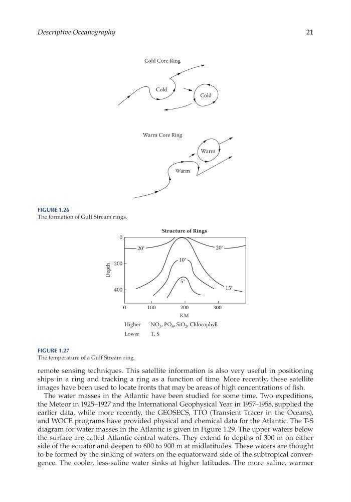
Figure 1.26
The formation of Gulf Stream rings.
0
Higher
NO 3 , PO 4 , SiO 2 , Chlorophyll
Lower
T, S
400
Depth
200
0
100
200
KM
Structure of Rings
300
5°
15°
20°
10°
20°
Figure 1.27
The temperature of a Gulf Stream ring.
Descriptive Oceanography
remote sensing techniques. This satellite information is also very useful in positioning
ships in a ring and tracking a ring as a function of time. More recently, these satellite
images have been used to locate fronts that may be areas of high concentrations of fish.
The water masses in the Atlantic have been studied for some time. Two expeditions,
the Meteor in 1925–1927 and the International Geophysical Year in 1957–1958, supplied the
earlier data, while more recently, the GEOSECS, TTO (Transient Tracer in the Oceans),
and WOCE programs have provided physical and chemical data for the Atlantic. The T-S
diagram for water masses in the Atlantic is given in Figure 1.29. The upper waters below
the surface are called Atlantic central waters. They extend to depths of 300 m on either
side of the equator and deepen to 600 to 900 m at midlatitudes. These waters are thought
to be formed by the sinking of waters on the equatorward side of the subtropical convergence. The cooler, less- saline water sinks at higher latitudes. The more saline, warmer
Cold Core Ring
Warm Core Ring
Warm
Warm
Cold
Cold
Figure 1.26
The formation of Gulf Stream rings.
0
Higher
NO 3 , PO 4 , SiO 2 , Chlorophyll
Lower
T, S
400
Depth
200
0
100
200
KM
Structure of Rings
300
5°
15°
20°
10°
20°
Figure 1.27
The temperature of a Gulf Stream ring.