

most important problems facing both WOCE and
TOGA and that researchers needed to ensure that
it was done properly, even though the topic bored
him to tears! So, in 1984 CCCO sponsored a
meeting jointly with the IOC’s Committees on International Oceanographic Data Exchange (IODE)
and the Integrated Global Ocean Services System
(IGOSS) to review and recommend the way forward. Shortly before, the US National Academy of
Sciences, Space Studies Board, Committee on Data
Management and Computation (National Research
Council, 1982) had extensively reviewed the successes and failings of present and past satellite data
management systems. It had identified some very
general principles for success. The meeting felt
these principles could easily be adapted to handle
WCRP scientific data. They included active endto-end involvement of scientists in the data acquisition and distribution process, peer review by the
user community of the data management activities,
data formats designed for ease of use by scientists,
and metadata (ancillary information) to be available with each data set.
For WOCE, there was the added challenge of
bringing together the data from three sources;
satellite systems, ship-based research systems, and
operational networks, each with its own mode of
operation and time scale of data delivery. By 1986
the WOCE SSG had developed a plan based on
these principles, which was to stand the test of
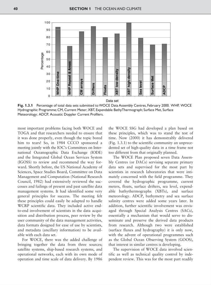
time. Now (2000) it has demonstrably delivered
(Fig. 1.3.1) to the scientific community an unprecedented set of high-quality data in a time frame not
too different from that originally planned.
The WOCE Plan proposed seven Data Assembly Centres (or DACs) servising separate primary
data sets and supervised for the most part by
scientists in research laboratories that were intimately concerned with the field programme. They
covered the hydrographic programme, current
meters, floats, surface drifters, sea level, expendable bathythermographs (XBTs), and surface
meteorology. ADCP, bathymetry and sea surface
salinity centres were added some years later. In
addition, further scientific involvement was envisaged through Special Analysis Centres (SACs),
essentially a mechanism that would serve to disseminate and preserve the derived data products
from research. Although two were established
(surface fluxes and hydrography) it is only now,
with the advent of operational programmes such
as the Global Ocean Observing System (GOOS),
that interest in similar centres is developing.
The supervision of WOCE data involved scientific as well as technical quality control by independent review. This was for the most part readily
SECTION 1 THE OCEAN AND CLIMATE
40
0
1 0
2 0
3 0
4 0
5 0
6 0
7 0
8 0
9 0
100
WHP One-time
WHP Repeat & Areas
CM arrays
Drifters
Floats
XBT low-density
XBT high-density
Sea level
Surface Met
ADCP
Percentage
Data set
Fig. 1.3.1 Percentage of total data sets submitted to WOCE Data Assembly Centres, February 2000. WHP, WOCE
Hydrographic Programme; CM, Current Meter; XBT, Expendable BathyThermograph; Surface Met, Surface
Meteorology; ADCP, Acoustic Doppler Current Profilers.
TOGA and that researchers needed to ensure that
it was done properly, even though the topic bored
him to tears! So, in 1984 CCCO sponsored a
meeting jointly with the IOC’s Committees on International Oceanographic Data Exchange (IODE)
and the Integrated Global Ocean Services System
(IGOSS) to review and recommend the way forward. Shortly before, the US National Academy of
Sciences, Space Studies Board, Committee on Data
Management and Computation (National Research
Council, 1982) had extensively reviewed the successes and failings of present and past satellite data
management systems. It had identified some very
general principles for success. The meeting felt
these principles could easily be adapted to handle
WCRP scientific data. They included active endto-end involvement of scientists in the data acquisition and distribution process, peer review by the
user community of the data management activities,
data formats designed for ease of use by scientists,
and metadata (ancillary information) to be available with each data set.
For WOCE, there was the added challenge of
bringing together the data from three sources;
satellite systems, ship-based research systems, and
operational networks, each with its own mode of
operation and time scale of data delivery. By 1986
the WOCE SSG had developed a plan based on
these principles, which was to stand the test of
time. Now (2000) it has demonstrably delivered
(Fig. 1.3.1) to the scientific community an unprecedented set of high-quality data in a time frame not
too different from that originally planned.
The WOCE Plan proposed seven Data Assembly Centres (or DACs) servising separate primary
data sets and supervised for the most part by
scientists in research laboratories that were intimately concerned with the field programme. They
covered the hydrographic programme, current
meters, floats, surface drifters, sea level, expendable bathythermographs (XBTs), and surface
meteorology. ADCP, bathymetry and sea surface
salinity centres were added some years later. In
addition, further scientific involvement was envisaged through Special Analysis Centres (SACs),
essentially a mechanism that would serve to disseminate and preserve the derived data products
from research. Although two were established
(surface fluxes and hydrography) it is only now,
with the advent of operational programmes such
as the Global Ocean Observing System (GOOS),
that interest in similar centres is developing.
The supervision of WOCE data involved scientific as well as technical quality control by independent review. This was for the most part readily
SECTION 1 THE OCEAN AND CLIMATE
40
0
1 0
2 0
3 0
4 0
5 0
6 0
7 0
8 0
9 0
100
WHP One-time
WHP Repeat & Areas
CM arrays
Drifters
Floats
XBT low-density
XBT high-density
Sea level
Surface Met
ADCP
Percentage
Data set
Fig. 1.3.1 Percentage of total data sets submitted to WOCE Data Assembly Centres, February 2000. WHP, WOCE
Hydrographic Programme; CM, Current Meter; XBT, Expendable BathyThermograph; Surface Met, Surface
Meteorology; ADCP, Acoustic Doppler Current Profilers.