

Introduction
The Gironde has the largest surface area of any estuary in Europe, and
is formed by the confluence of the Garonne and Dordogne rivers
(fig. 1). The seaward sloping thalweg is incised into a Tertiary carbonate
substratum and has a maximum depth, at the mouth of the Gironde, of
45 m below the present M.S.L. (Allen & Posamentier, 1993). The
morphologt' of the Gironde estuary is typical of wave and tide dominated estuaries, consisting of meandering upper estuary 7 channels with
tidal dominated sand and mud estuarine point bars; a mid-estuary funnel-shaped channel containing linear tidal sand bars and estuarine mud;
and an estuarine mouth with deeply scoured (35 m) tidal inlet termtnating seaward and landward in sandy shoals.
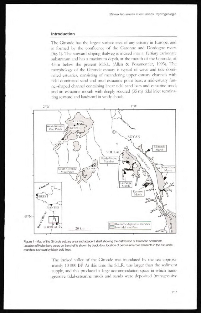
Figure 1 - Map of the Gironde estuary area and adjacent shelf showing the distribution of Holocene sediments.
Location of Kullenberg cores on the shelf is shown by black dots, location of percussion core transects in the estuarine
marshes is shown by black bold lines.
The incised valley of the Gironde was inundated by the sea approximately 10 000 BP At this time the S.L.R. was larger than the sediment
supply, and this produced a large accommodation space in which transgressive tidal-estuarine muds and sands were deposited (transgressive
237
The Gironde has the largest surface area of any estuary in Europe, and
is formed by the confluence of the Garonne and Dordogne rivers
(fig. 1). The seaward sloping thalweg is incised into a Tertiary carbonate
substratum and has a maximum depth, at the mouth of the Gironde, of
45 m below the present M.S.L. (Allen & Posamentier, 1993). The
morphologt' of the Gironde estuary is typical of wave and tide dominated estuaries, consisting of meandering upper estuary 7 channels with
tidal dominated sand and mud estuarine point bars; a mid-estuary funnel-shaped channel containing linear tidal sand bars and estuarine mud;
and an estuarine mouth with deeply scoured (35 m) tidal inlet termtnating seaward and landward in sandy shoals.
Figure 1 - Map of the Gironde estuary area and adjacent shelf showing the distribution of Holocene sediments.
Location of Kullenberg cores on the shelf is shown by black dots, location of percussion core transects in the estuarine
marshes is shown by black bold lines.
The incised valley of the Gironde was inundated by the sea approximately 10 000 BP At this time the S.L.R. was larger than the sediment
supply, and this produced a large accommodation space in which transgressive tidal-estuarine muds and sands were deposited (transgressive
237