

and how the sandbank is maintained under the present hydrodynamic
conditions. Data collected in the vicinity of the Saint-Georges Bank are
presented and integrated to define current patterns around the bank.
These measurements are briefly compared with previous studies (Port
autonome de Bordeaux, 1980; Mallet et al., 2000) and different theories
on formation and maintenance of sandbanks (Dyer& Huntley, 1999).
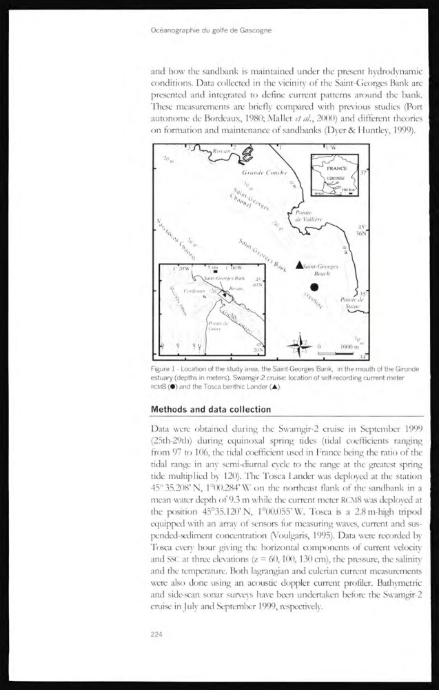
Figure 1 - Location of the study area, the Saint-Georges Bank, in the mouth of the Gironde
estuary (depths in meters). Swamgir-2 cruise: location of self-recording current meter
RCM8 (•) and the Tosca benthic Lander (A).
Methods and data collection
Data were obtained during the Swamgir-2 cruise in September 1999
(25th-29th) during equinoxal spring tides (tidal coefficients ranging
from 97 to 106, the tidal coefficient used in France being the ratio of the
tidal range in anv semi-diurnal cvcle to the range at the greatest spring
tide multiplied by 120). The Tosca Lander was deployed at the station
45" 35.208’N, 1°00.284’\X' on the northeast flank of the sandbank in a
mean water depth of 9.3 m while the current meter RCM8 was deployed at
the position 45°35.120’N, 1°00.055’\V. Tosca is a 2.8 m-high tripod
equipped with an array of sensors for measuring waves, current and suspended-sediment concentration (Voulgaris, 1995). Data were recorded by
Tosca every hour giving the horizontal components of current velocity
and SSC at three elevations (/ = 60,100, 130 cm), the pressure, the salinity
and the temperature. Both lagrangian and eulerian current measurements
were also done using an acoustic doppler current profiler. BathyTnetric
and side-scan sonar surveys have been undertaken before the Swamgir-2
cmise in July and September 1999, respectively.
224
conditions. Data collected in the vicinity of the Saint-Georges Bank are
presented and integrated to define current patterns around the bank.
These measurements are briefly compared with previous studies (Port
autonome de Bordeaux, 1980; Mallet et al., 2000) and different theories
on formation and maintenance of sandbanks (Dyer& Huntley, 1999).
Figure 1 - Location of the study area, the Saint-Georges Bank, in the mouth of the Gironde
estuary (depths in meters). Swamgir-2 cruise: location of self-recording current meter
RCM8 (•) and the Tosca benthic Lander (A).
Methods and data collection
Data were obtained during the Swamgir-2 cruise in September 1999
(25th-29th) during equinoxal spring tides (tidal coefficients ranging
from 97 to 106, the tidal coefficient used in France being the ratio of the
tidal range in anv semi-diurnal cvcle to the range at the greatest spring
tide multiplied by 120). The Tosca Lander was deployed at the station
45" 35.208’N, 1°00.284’\X' on the northeast flank of the sandbank in a
mean water depth of 9.3 m while the current meter RCM8 was deployed at
the position 45°35.120’N, 1°00.055’\V. Tosca is a 2.8 m-high tripod
equipped with an array of sensors for measuring waves, current and suspended-sediment concentration (Voulgaris, 1995). Data were recorded by
Tosca every hour giving the horizontal components of current velocity
and SSC at three elevations (/ = 60,100, 130 cm), the pressure, the salinity
and the temperature. Both lagrangian and eulerian current measurements
were also done using an acoustic doppler current profiler. BathyTnetric
and side-scan sonar surveys have been undertaken before the Swamgir-2
cmise in July and September 1999, respectively.
224