

System design and organization, access to data
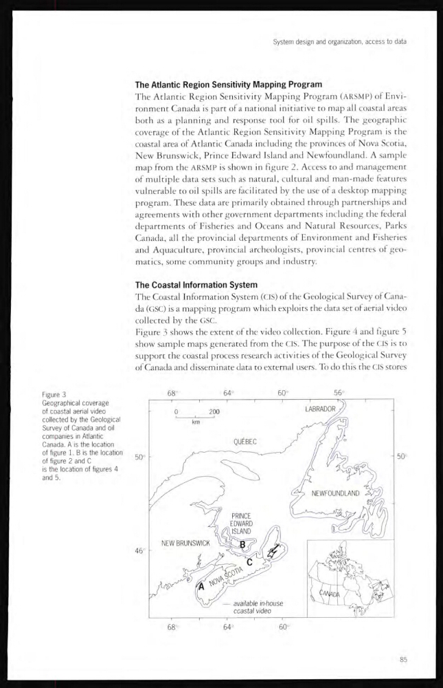
Figure 3
Geographical coverage
of coastal aerial video
collected by the Geological
Survey of Canada and oil
companies in Atlantic
Canada. A is the location
of figure 1. B is the location
of figure 2 and C
is the location of figures 4
and 5.
The Atlantic Region Sensitivity Mapping Program
The Atlantic Region Sensitivity Mapping Program (ARSMP) of Environment Canada is part of a national initiative to map all coastal areas
both as a planning and response tool for oil spills. The geographic
coverage of the Atlantic Region Sensitivity Mapping Program is the
coastal area of Atlantic Canada including the provinces of Nova Scotia,
New Brunswick, Prince Edward Island and Newfoundland. A sample
map from the ARSMP is shown in figure Access to and management
of multiple data sets such as natural, cultural and man-made features
vulnerable to oil spills are facilitated by the use of a desktop mapping
program. These data are primarily obtained through partnerships and
agreements with other government departments including the federal
departments of Fisheries and Oceans and Natural Resources, Parks
Canada, all rhe provincial departments of Environment and Fisheries
and Aquaculture, provincial archeologists, provincial centres of geomatics, some community groups and industry.
The Coastal Information System
The Coastal Information System (CIS) of the Geological Survey of Canada (GSC) is a mapping program which exploits the data set of aerial video
collected by the GSC.
Figure 3 shows the extent of the video collection. Figure 4 and figure 5
show sample maps generated from the CIS. The purpose of the CIS is to
support the coastal process research activities ol the Geological Survey
of Canada and disseminate data to external users. To do this the CIS stores
85
Figure 3
Geographical coverage
of coastal aerial video
collected by the Geological
Survey of Canada and oil
companies in Atlantic
Canada. A is the location
of figure 1. B is the location
of figure 2 and C
is the location of figures 4
and 5.
The Atlantic Region Sensitivity Mapping Program
The Atlantic Region Sensitivity Mapping Program (ARSMP) of Environment Canada is part of a national initiative to map all coastal areas
both as a planning and response tool for oil spills. The geographic
coverage of the Atlantic Region Sensitivity Mapping Program is the
coastal area of Atlantic Canada including the provinces of Nova Scotia,
New Brunswick, Prince Edward Island and Newfoundland. A sample
map from the ARSMP is shown in figure Access to and management
of multiple data sets such as natural, cultural and man-made features
vulnerable to oil spills are facilitated by the use of a desktop mapping
program. These data are primarily obtained through partnerships and
agreements with other government departments including the federal
departments of Fisheries and Oceans and Natural Resources, Parks
Canada, all rhe provincial departments of Environment and Fisheries
and Aquaculture, provincial archeologists, provincial centres of geomatics, some community groups and industry.
The Coastal Information System
The Coastal Information System (CIS) of the Geological Survey of Canada (GSC) is a mapping program which exploits the data set of aerial video
collected by the GSC.
Figure 3 shows the extent of the video collection. Figure 4 and figure 5
show sample maps generated from the CIS. The purpose of the CIS is to
support the coastal process research activities ol the Geological Survey
of Canada and disseminate data to external users. To do this the CIS stores
85