

Regulatory aspects
the Adantic Ocean (with tides) and the Mediterranean Sea (without
tides), and although the transidon area is small, the sea level changes
greatly with the tide. A solution for this complex situation would be
to develop one GIS for the Atlantic and another for the Mediterranean
Sea, but the system and the information should be continuous for the
whole continental shelf.
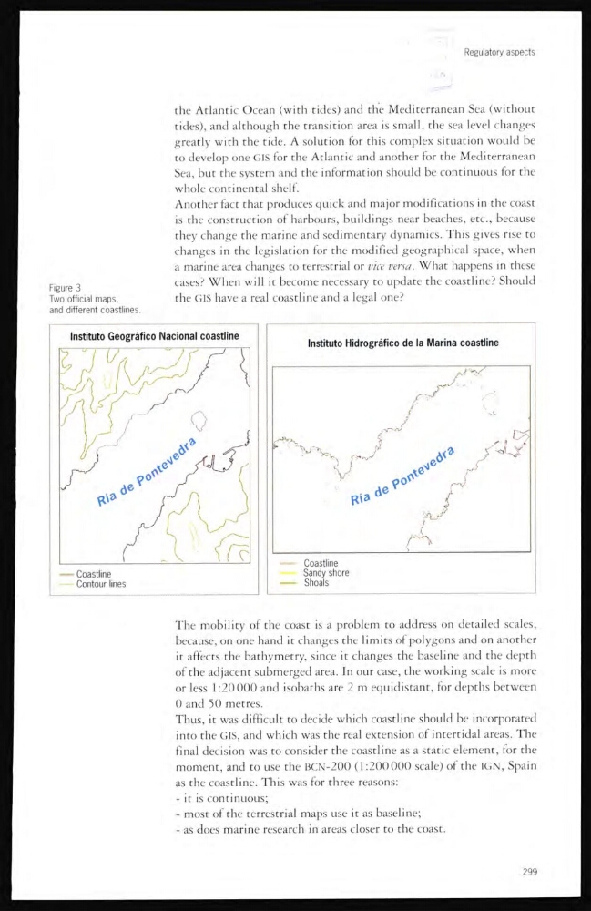
Another fact that produces quick and major modifications in the coast
is the construction of harbours, buildings near beaches, etc., because
they change the marine and sedimentary dynamics. This gives rise to
changes in the legislation for the modified geographical space, when
a marine area changes to terrestrial or vice versa. What happens in these
cases? When will it become necessary to update the coastline? Should
the GfS have a real coastline and a legal one?
Figure 3
Two officia! maps,
and different coastlines.
The mobility of the coast is a problem to address on detailed scales,
because, on one hand it changes the limits of polygons and on another
it affects the bathymetry, since it changes the baseline and the depth
of the adjacent submerged area. In our case, the working scale is more
or less 1:20 000 and isobaths are 2 m equidistant, for depths between
0 and 50 metres.
Thus, it was difficult to decide which coastline should be incorporated
into the GIS, and which was the real extension of intertidal areas. The
final decision was to consider the coastline as a static element, for the
moment, and to use the BCN-200 (1:200000 scale) of the IGN, Spain
as the coastline. This was for three reasons:
- it is continuous;
- most of the terrestrial maps use it as baseline;
- as does marine research m areas closer to the coast.
299
the Adantic Ocean (with tides) and the Mediterranean Sea (without
tides), and although the transidon area is small, the sea level changes
greatly with the tide. A solution for this complex situation would be
to develop one GIS for the Atlantic and another for the Mediterranean
Sea, but the system and the information should be continuous for the
whole continental shelf.
Another fact that produces quick and major modifications in the coast
is the construction of harbours, buildings near beaches, etc., because
they change the marine and sedimentary dynamics. This gives rise to
changes in the legislation for the modified geographical space, when
a marine area changes to terrestrial or vice versa. What happens in these
cases? When will it become necessary to update the coastline? Should
the GfS have a real coastline and a legal one?
Figure 3
Two officia! maps,
and different coastlines.
The mobility of the coast is a problem to address on detailed scales,
because, on one hand it changes the limits of polygons and on another
it affects the bathymetry, since it changes the baseline and the depth
of the adjacent submerged area. In our case, the working scale is more
or less 1:20 000 and isobaths are 2 m equidistant, for depths between
0 and 50 metres.
Thus, it was difficult to decide which coastline should be incorporated
into the GIS, and which was the real extension of intertidal areas. The
final decision was to consider the coastline as a static element, for the
moment, and to use the BCN-200 (1:200000 scale) of the IGN, Spain
as the coastline. This was for three reasons:
- it is continuous;
- most of the terrestrial maps use it as baseline;
- as does marine research m areas closer to the coast.
299