

Environmental and resource applications
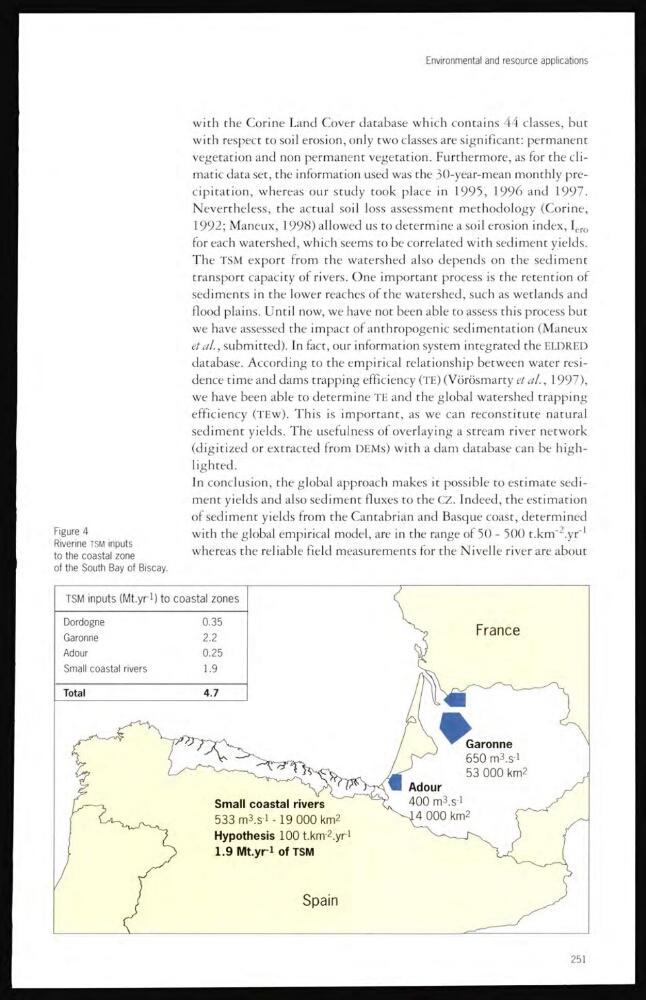
Figure 4
Riverine TSM inputs
to the coastal zone
of the South Bay of Biscay.
with the Corine Land Cover database which contains 44 classes, but
with respect to soil erosion, only two classes are significant: permanent
vegetation and non permanent vegetation. Furthermore, as for the climatic data set, the information used was the 30-year-mean monthly precipitation, whereas our study took place in 1995, 1996 and 1997.
Nevertheless, the actual soil loss assessment methodology (Corine,
1992; Maneux, 1998) allowed us to determine a soil erosion index, I ero
for each watershed, which seems to be correlated with sediment yields.
The TSM export from the watershed also depends on the sediment
transport capacity of rivers. One important process is the retention of
sediments in the lower reaches of the watershed, such as wetlands and
flood plains. Until now, we have not been able to assess this process but
we have assessed the impact of anthropogenic sedimentation (Maneux
etsubmitted). In fact, our information system integrated the ELDRED
database. According to the empirical relationship between water residence time and dams trapping efficiency (TE) (Vörösmarty et al., 1997),
we have been able to determine TE and the global watershed trapping
efficiency (TEw). This is important, as we can reconstitute natural
sediment yields. The usefulness of overlaying a stream river network
(digitized or extracted from DEMs) with a dam database can be highlighted.
In conclusion, the global approach makes it possible to estimate sediment yields and also sediment fluxes to the CZ. Indeed, the cstimation
of sediment yields from the Cantabrian and Basque coast, determined
with the global empirical model, are in the range of 50 - 500 t.krrfcyC
1
whereas the reliable field measurements for the Nivelle river are about
251
Figure 4
Riverine TSM inputs
to the coastal zone
of the South Bay of Biscay.
with the Corine Land Cover database which contains 44 classes, but
with respect to soil erosion, only two classes are significant: permanent
vegetation and non permanent vegetation. Furthermore, as for the climatic data set, the information used was the 30-year-mean monthly precipitation, whereas our study took place in 1995, 1996 and 1997.
Nevertheless, the actual soil loss assessment methodology (Corine,
1992; Maneux, 1998) allowed us to determine a soil erosion index, I ero
for each watershed, which seems to be correlated with sediment yields.
The TSM export from the watershed also depends on the sediment
transport capacity of rivers. One important process is the retention of
sediments in the lower reaches of the watershed, such as wetlands and
flood plains. Until now, we have not been able to assess this process but
we have assessed the impact of anthropogenic sedimentation (Maneux
etsubmitted). In fact, our information system integrated the ELDRED
database. According to the empirical relationship between water residence time and dams trapping efficiency (TE) (Vörösmarty et al., 1997),
we have been able to determine TE and the global watershed trapping
efficiency (TEw). This is important, as we can reconstitute natural
sediment yields. The usefulness of overlaying a stream river network
(digitized or extracted from DEMs) with a dam database can be highlighted.
In conclusion, the global approach makes it possible to estimate sediment yields and also sediment fluxes to the CZ. Indeed, the cstimation
of sediment yields from the Cantabrian and Basque coast, determined
with the global empirical model, are in the range of 50 - 500 t.krrfcyC
1
whereas the reliable field measurements for the Nivelle river are about
251