

CoastGIS’99: geomatics and coastal environment
Introduction
The German Federal State of Schleswig-Holstein lies between two seas,
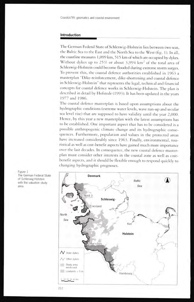
the Baltic Sea to the East and the North Sea to the West (fig. 1). In all,
the coastline measures 1,099 km, 515 km of which are occupied by dykes.
Without dykes up to 25% or about 3,994 km
2 of the total area of
Schleswig-Holstein could become flooded during extreme storm surges.
To prevent this, the coastal defence authorities established in 1963 a
masterplan “Dike-reinforcement, dike-shortening and coastal defence
in Schleswig-Holstein” that represents the legal, technical and financial
concepts for coastal defence works in Schleswig-Holstein. The plan is
described in detail by Hofstede (1993). It has been updated in the years
1977 and 1986.
The coastal defence masterplan is based upon assumptions about the
hydrographic conditions (extreme water levels, wave run-up and secular
sea level rise) that are supposed to have validity until the year 2,000.
Hence, by this year a new masterplan with the latest assumptions has
to be established. One important aspect that has to be considered is a
possible anthropogenic climate change and its hydrographic consequences. Furthermore, population and values in the protected areas
have increased considerably since 1963. Finally, environmental, touristical as well as cost-benefit aspects have gained much more importance
over the last decades. In consequence, the new coastal defence masterplan must consider other interests in the coastal zone as well as costbenefit aspects, and it should be flexible enough to respond quickly to
changing hydrographic prognoses.
Figure 1
The German Federal State
of Schleswlg-Holstein
with the valuation study
area.
212
Introduction
The German Federal State of Schleswig-Holstein lies between two seas,
the Baltic Sea to the East and the North Sea to the West (fig. 1). In all,
the coastline measures 1,099 km, 515 km of which are occupied by dykes.
Without dykes up to 25% or about 3,994 km
2 of the total area of
Schleswig-Holstein could become flooded during extreme storm surges.
To prevent this, the coastal defence authorities established in 1963 a
masterplan “Dike-reinforcement, dike-shortening and coastal defence
in Schleswig-Holstein” that represents the legal, technical and financial
concepts for coastal defence works in Schleswig-Holstein. The plan is
described in detail by Hofstede (1993). It has been updated in the years
1977 and 1986.
The coastal defence masterplan is based upon assumptions about the
hydrographic conditions (extreme water levels, wave run-up and secular
sea level rise) that are supposed to have validity until the year 2,000.
Hence, by this year a new masterplan with the latest assumptions has
to be established. One important aspect that has to be considered is a
possible anthropogenic climate change and its hydrographic consequences. Furthermore, population and values in the protected areas
have increased considerably since 1963. Finally, environmental, touristical as well as cost-benefit aspects have gained much more importance
over the last decades. In consequence, the new coastal defence masterplan must consider other interests in the coastal zone as well as costbenefit aspects, and it should be flexible enough to respond quickly to
changing hydrographic prognoses.
Figure 1
The German Federal State
of Schleswlg-Holstein
with the valuation study
area.
212