

CoastGIS’99: geomatics and coastal environment
The GeoNet 4D Project
GeoNet 4D is a 30-month project in the framework of the Esprit Programme of the European Commission’s DG III. It aims at demonstrating
and evaluating the usefulness of several combined advanced technologies
(GIS, Internet/intranet & Multimedia) for European users. GeoNet 4D
primarily focuses on applications for environmental and commercial
activities in port and coastal areas.
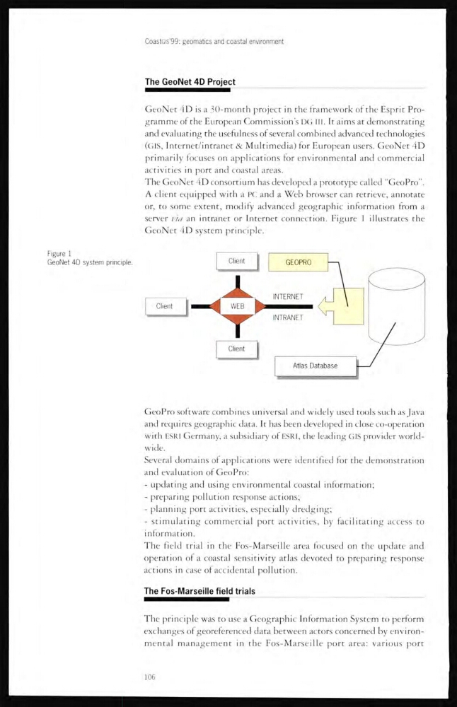
The GeoNet 4D consortium has developed a prototype called “GeoPro”.
A client equipped with a PC and a Web browser can retrieve, annotate
or, to some extent, modify advanced geographic information from a
server via an intranet or Internet connection. Figure 1 illustrates the
GeoNet 4D system principle.
Figure 1
GeoNet 4D system principle.
GeoPro software combines universal and widely used tools such as Java
and requires geographic data. It has been developed in close co-operation
with ESRI Germany, a subsidiary of ESRI, the leading GIS provider worldwide.
Several domains of applications were identified for the demonstration
and evaluation of GeoPro:
- updating and using environmental coastal information;
- preparing pollution response actions;
- planning port activities, especially dredging;
- stimulating commercial port activities, by facilitating access to
information.
The field trial in the Fos-Marseille area focused on the update and
operation ol a coastal sensitivity atlas devoted to preparing response
actions in case of accidental pollution.
The Fos-Marseille field trials
The principle was to use a Geographic Information System to perform
exchanges of georeferenced-data between actors concerned by environmental management in the Fos-Marseille port area: various port
106
The GeoNet 4D Project
GeoNet 4D is a 30-month project in the framework of the Esprit Programme of the European Commission’s DG III. It aims at demonstrating
and evaluating the usefulness of several combined advanced technologies
(GIS, Internet/intranet & Multimedia) for European users. GeoNet 4D
primarily focuses on applications for environmental and commercial
activities in port and coastal areas.
The GeoNet 4D consortium has developed a prototype called “GeoPro”.
A client equipped with a PC and a Web browser can retrieve, annotate
or, to some extent, modify advanced geographic information from a
server via an intranet or Internet connection. Figure 1 illustrates the
GeoNet 4D system principle.
Figure 1
GeoNet 4D system principle.
GeoPro software combines universal and widely used tools such as Java
and requires geographic data. It has been developed in close co-operation
with ESRI Germany, a subsidiary of ESRI, the leading GIS provider worldwide.
Several domains of applications were identified for the demonstration
and evaluation of GeoPro:
- updating and using environmental coastal information;
- preparing pollution response actions;
- planning port activities, especially dredging;
- stimulating commercial port activities, by facilitating access to
information.
The field trial in the Fos-Marseille area focused on the update and
operation ol a coastal sensitivity atlas devoted to preparing response
actions in case of accidental pollution.
The Fos-Marseille field trials
The principle was to use a Geographic Information System to perform
exchanges of georeferenced-data between actors concerned by environmental management in the Fos-Marseille port area: various port
106