

216
J. A. KITCHINO AND F. J. EBLING
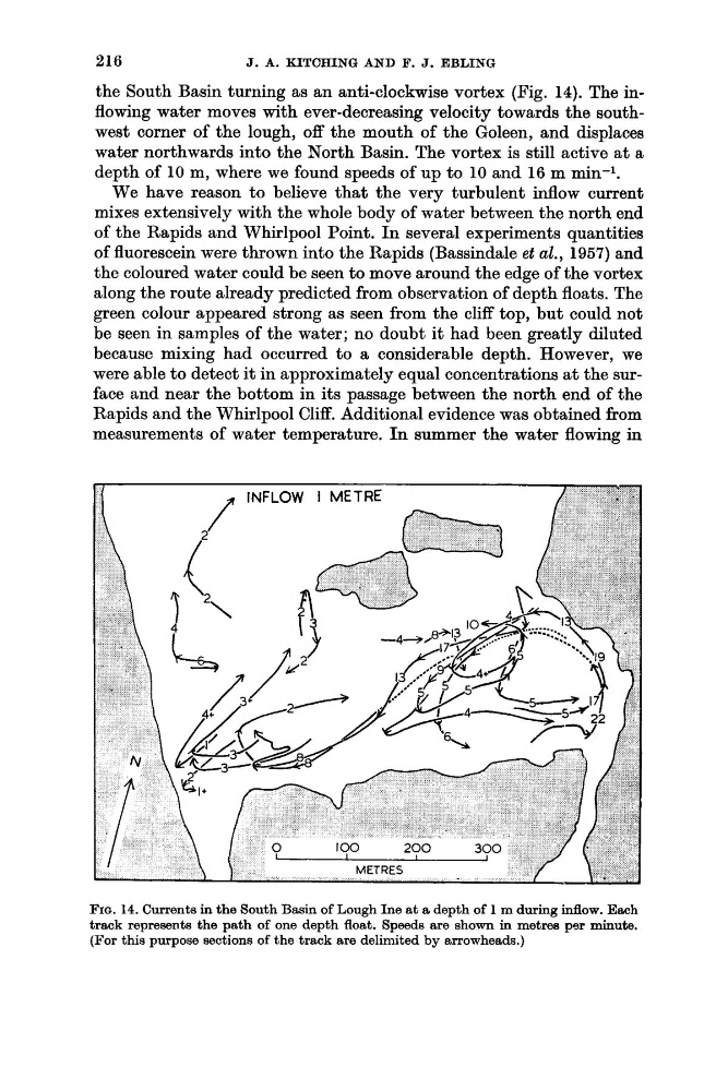
the South Basin turning as an anti-clockwise vortex (Fig. 14). The inflowing water moves with ever-decreasing velocity towards the southwest corner of the lough, off the mouth of the Goleen, and displaces
water northwards into the North Basin. The vortex is still active at a
depth of 10 m, where we found speeds of up to 10 and 16 m min-1.
We have reason to believe that the very turbulent inflow current
mixes extensively with the whole body of water between the north end
of the Rapids and Whirlpool Point. In several experiments quantities
of fluorescein were thrown into the Rapids (Bassindale et al., 1957) and
the coloured water could be seen to move around the edge of the vortex
along the route already predicted from observation of depth floats. The
green colour appeared strong as seen from the cliff top, but could not
be seen in samples of the water; no doubt it had been greatly diluted
because mixing had occurred to a considerable depth. However, we
were able to detect it in approximately equal concentrations at the surface and near the bottom in its passage between the north end of the
Rapids and the Whirlpool Cliff. Additional evidence was obtained from
measurements of water temperature. In summer the water flowing in
FIQ. 14. Currents in the South Basin of Lough h e at a depth of 1 m during inflow. Each
track represents the path of one depth float. Speeds are shown in metres per minute.
(For this purpose sections of the track are delimited by arrowheads.)
J. A. KITCHINO AND F. J. EBLING
the South Basin turning as an anti-clockwise vortex (Fig. 14). The inflowing water moves with ever-decreasing velocity towards the southwest corner of the lough, off the mouth of the Goleen, and displaces
water northwards into the North Basin. The vortex is still active at a
depth of 10 m, where we found speeds of up to 10 and 16 m min-1.
We have reason to believe that the very turbulent inflow current
mixes extensively with the whole body of water between the north end
of the Rapids and Whirlpool Point. In several experiments quantities
of fluorescein were thrown into the Rapids (Bassindale et al., 1957) and
the coloured water could be seen to move around the edge of the vortex
along the route already predicted from observation of depth floats. The
green colour appeared strong as seen from the cliff top, but could not
be seen in samples of the water; no doubt it had been greatly diluted
because mixing had occurred to a considerable depth. However, we
were able to detect it in approximately equal concentrations at the surface and near the bottom in its passage between the north end of the
Rapids and the Whirlpool Cliff. Additional evidence was obtained from
measurements of water temperature. In summer the water flowing in
FIQ. 14. Currents in the South Basin of Lough h e at a depth of 1 m during inflow. Each
track represents the path of one depth float. Speeds are shown in metres per minute.
(For this purpose sections of the track are delimited by arrowheads.)