

50
2. Formulating
the
Problem
$
30 Γ
8
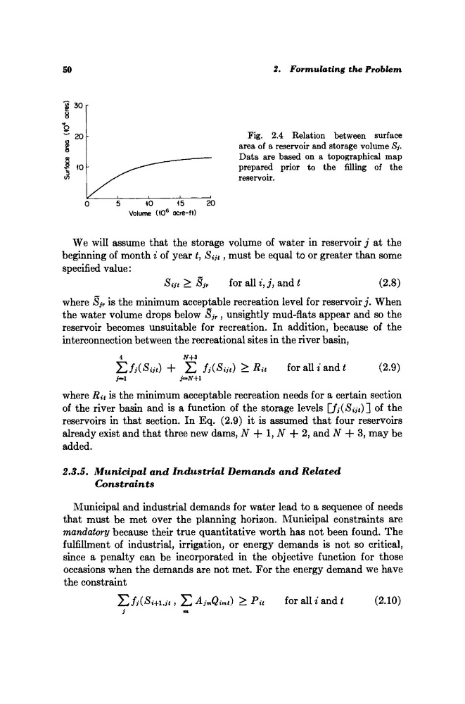
Fig. 2.4 Relation between surface
area of a reservoir and storage volume Sj.
Data are based on a topographical map
prepared prior to the filling of the
reservoir.
We will assume that the storage volume of water in reservoir j at the
beginning of month i of year i, Sm , must be equal to or greater than some
specified value:
Sat > S jr
for all i, j, and t
(2.8)
where Sj r is the minimum acceptable recreation level for reservoir j. When
the water volume drops below Sj r , unsightly mud-flats appear and so the
reservoir becomes unsuitable for recreation. In addition, because of the
interconnection between the recreational sites in the river basin,
4
iV+3
ΣΛ(^«Ι) + Σ fi(Sijt) >Ra
for alii and ί
(2.9)
i-i
j=*N+l
where Ru is the minimum acceptable recreation needs for a certain section
of the river basin and is a function of the storage levels
of the
reservoirs in that section. In Eq. (2.9) it is assumed that four reservoirs
already exist and that three new dams, ΛΓ + 1, # -f- 2, and Ν + 3, may be
added.
2.3.5. Municipal
and Industrial
Demands
and
Related
Constraints
Municipal and industrial demands for water lead to a sequence of needs
that must be met over the planning horizon. Municipal constraints are
mandatory because their true quantitative worth has not been found. The
fulfillment of industrial, irrigation, or energy demands is not so critical,
since a penalty can be incorporated in the objective function for those
occasions when the demands are not met. For the energy demand we have
the constraint
Σι
Σ AjmQimt)
> Pu
for all i and t
(2.10)
j
tn
2. Formulating
the
Problem
$
30 Γ
8
Fig. 2.4 Relation between surface
area of a reservoir and storage volume Sj.
Data are based on a topographical map
prepared prior to the filling of the
reservoir.
We will assume that the storage volume of water in reservoir j at the
beginning of month i of year i, Sm , must be equal to or greater than some
specified value:
Sat > S jr
for all i, j, and t
(2.8)
where Sj r is the minimum acceptable recreation level for reservoir j. When
the water volume drops below Sj r , unsightly mud-flats appear and so the
reservoir becomes unsuitable for recreation. In addition, because of the
interconnection between the recreational sites in the river basin,
4
iV+3
ΣΛ(^«Ι) + Σ fi(Sijt) >Ra
for alii and ί
(2.9)
i-i
j=*N+l
where Ru is the minimum acceptable recreation needs for a certain section
of the river basin and is a function of the storage levels
of the
reservoirs in that section. In Eq. (2.9) it is assumed that four reservoirs
already exist and that three new dams, ΛΓ + 1, # -f- 2, and Ν + 3, may be
added.
2.3.5. Municipal
and Industrial
Demands
and
Related
Constraints
Municipal and industrial demands for water lead to a sequence of needs
that must be met over the planning horizon. Municipal constraints are
mandatory because their true quantitative worth has not been found. The
fulfillment of industrial, irrigation, or energy demands is not so critical,
since a penalty can be incorporated in the objective function for those
occasions when the demands are not met. For the energy demand we have
the constraint
Σι
Σ AjmQimt)
> Pu
for all i and t
(2.10)
j
tn