

263
Glaciers: A Part of Two Basic Cycles
A glacier is a thick ice mass that forms
over hundreds or thousands of years. It
originates on land from the accumulation,
compaction, and recrystallization of snow.
A glacier appears to be motionless, but it
is not—glaciers move very slowly. Like
running water, groundwater, wind, and
waves, glaciers are dynamic erosional
agents that accumulate, transport, and
deposit sediment. As such, glaciers are
among the processes that perform a very
basic function in the rock cycle. Although
glaciers are found in many parts of the
world today, most are located in remote
areas, either near Earth’ s poles or in high
mountains.
Valley (Alpine) Glaciers
Literally thousands of relatively small
glaciers exist in lofty mountain areas,
where they usually follow valleys that were
originally occupied by streams. Unlike the
rivers that previously flowed in these valleys, the glaciers advance slowly, perhaps
only a few centimeters per day. Because of
their setting, these moving ice masses are
termed valley glaciers or alpine glaciers
(see Figure 11.1). Each glacier is a stream
of ice, bounded by precipitous rock walls,
that flows downvalley from a snow accumulation center near its head. Like rivers,
valley glaciers can be long or short, wide
or narrow, single or with branching tributaries. Generally, the widths of alpine
glaciers are small compared to their
lengths. Some extend for just a fraction of
a kilometer, whereas others go on for many
tens of kilometers. The west branch of the
Hubbard Glacier, for example, runs
through 112 kilometers (nearly 70 miles)
of mountainous terrain in Alaska and the
Yukon Territory.
on the surface of the ice. Such topographic
differences, however, do affect the behavior
of the ice sheets, especially near their
margins, by guiding flow in certain directions and creating zones of faster and
slower movement.
Along portions of the Antarctic coast,
glacial ice flows into the adjacent ocean,
creating features called ice shelves. They
are large, relatively flat masses of floating
ice that extend seaward from the coast
but remain attached to the land along one
D I D Y O U K N O W ?
Approximately 160,000 glaciers
presently occupy Earth’s polar regions
and high mountain environments.
Today’s glaciers cover only about one
third of the area that was covered at
the height of the most recent Ice Age.
Greenland
Antarctica
North
Pole
South
Pole
Ross Ice
Shelf
Filchner
Ice Shelf
Antarctic
Peninsula
Larson B
Ice Shelf
Weddell
Sea
Arcti c C ir c le
A nt arc tic Ci rc le
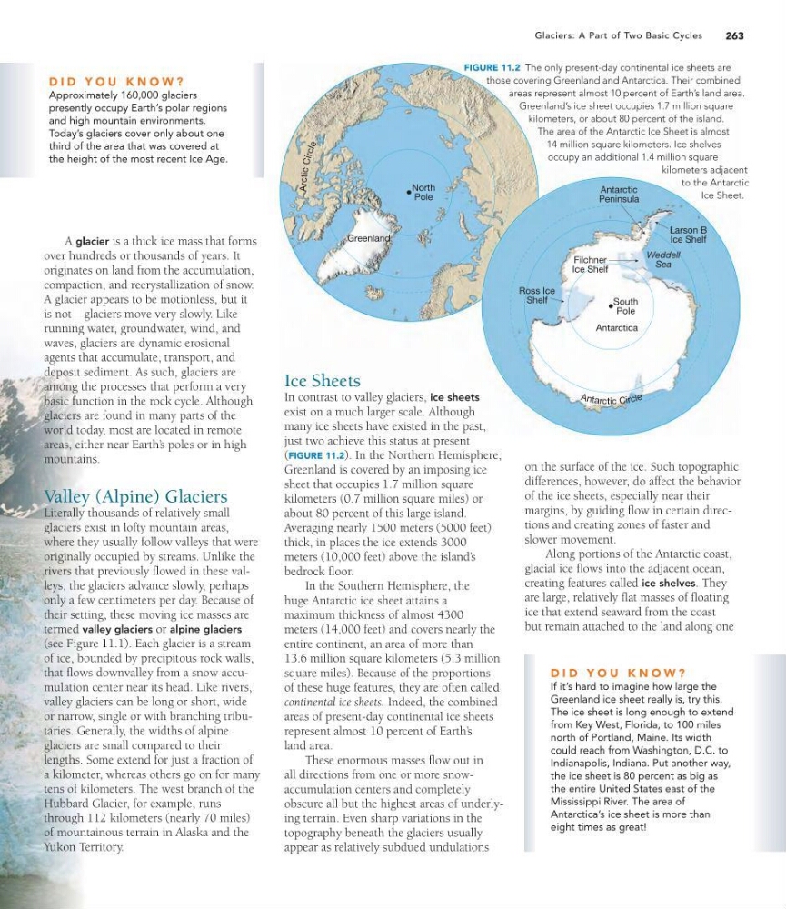
FIGURE 11.2 The only present-day continental ice sheets are
those covering Greenland and Antarctica. Their combined
areas represent almost 10 percent of Earth’s land area.
Greenland’s ice sheet occupies 1.7 million square
kilometers, or about 80 percent of the island.
The area of the Antarctic Ice Sheet is almost
14 million square kilometers. Ice shelves
occupy an additional 1.4 million square
kilometers adjacent
to the Antarctic
Ice Sheet.
Ice Sheets
In contrast to valley glaciers, ice sheets
exist on a much larger scale. Although
many ice sheets have existed in the past,
just two achieve this status at present
(FIGURE 11.2). In the Northern Hemisphere,
Greenland is covered by an imposing ice
sheet that occupies 1.7 million square
kilometers (0.7 million square miles) or
about 80 percent of this large island.
Averaging nearly 1500 meters (5000 feet)
thick, in places the ice extends 3000
meters (10,000 feet) above the island’ s
bedrock floor.
In the Southern Hemisphere, the
huge Antarctic ice sheet attains a
maximum thickness of almost 4300
meters (14,000 feet) and covers nearly the
entire continent, an area of more than
13.6 million square kilometers (5.3 million
square miles). Because of the proportions
of these huge features, they are often called
continental ice sheets. Indeed, the combined
areas of present-day continental ice sheets
represent almost 10 percent of Earth’ s
land area.
These enormous masses flow out in
all directions from one or more snowaccumulation centers and completely
obscure all but the highest areas of underlying terrain. Even sharp variations in the
topography beneath the glaciers usually
appear as relatively subdued undulations
D I D Y O U K N O W ?
If it’s hard to imagine how large the
Greenland ice sheet really is, try this.
The ice sheet is long enough to extend
from Key West, Florida, to 100 miles
north of Portland, Maine. Its width
could reach from Washington, D.C. to
Indianapolis, Indiana. Put another way,
the ice sheet is 80 percent as big as
the entire United States east of the
Mississippi River. The area of
Antarctica’s ice sheet is more than
eight times as great!
Glaciers: A Part of Two Basic Cycles
A glacier is a thick ice mass that forms
over hundreds or thousands of years. It
originates on land from the accumulation,
compaction, and recrystallization of snow.
A glacier appears to be motionless, but it
is not—glaciers move very slowly. Like
running water, groundwater, wind, and
waves, glaciers are dynamic erosional
agents that accumulate, transport, and
deposit sediment. As such, glaciers are
among the processes that perform a very
basic function in the rock cycle. Although
glaciers are found in many parts of the
world today, most are located in remote
areas, either near Earth’ s poles or in high
mountains.
Valley (Alpine) Glaciers
Literally thousands of relatively small
glaciers exist in lofty mountain areas,
where they usually follow valleys that were
originally occupied by streams. Unlike the
rivers that previously flowed in these valleys, the glaciers advance slowly, perhaps
only a few centimeters per day. Because of
their setting, these moving ice masses are
termed valley glaciers or alpine glaciers
(see Figure 11.1). Each glacier is a stream
of ice, bounded by precipitous rock walls,
that flows downvalley from a snow accumulation center near its head. Like rivers,
valley glaciers can be long or short, wide
or narrow, single or with branching tributaries. Generally, the widths of alpine
glaciers are small compared to their
lengths. Some extend for just a fraction of
a kilometer, whereas others go on for many
tens of kilometers. The west branch of the
Hubbard Glacier, for example, runs
through 112 kilometers (nearly 70 miles)
of mountainous terrain in Alaska and the
Yukon Territory.
on the surface of the ice. Such topographic
differences, however, do affect the behavior
of the ice sheets, especially near their
margins, by guiding flow in certain directions and creating zones of faster and
slower movement.
Along portions of the Antarctic coast,
glacial ice flows into the adjacent ocean,
creating features called ice shelves. They
are large, relatively flat masses of floating
ice that extend seaward from the coast
but remain attached to the land along one
D I D Y O U K N O W ?
Approximately 160,000 glaciers
presently occupy Earth’s polar regions
and high mountain environments.
Today’s glaciers cover only about one
third of the area that was covered at
the height of the most recent Ice Age.
Greenland
Antarctica
North
Pole
South
Pole
Ross Ice
Shelf
Filchner
Ice Shelf
Antarctic
Peninsula
Larson B
Ice Shelf
Weddell
Sea
Arcti c C ir c le
A nt arc tic Ci rc le
FIGURE 11.2 The only present-day continental ice sheets are
those covering Greenland and Antarctica. Their combined
areas represent almost 10 percent of Earth’s land area.
Greenland’s ice sheet occupies 1.7 million square
kilometers, or about 80 percent of the island.
The area of the Antarctic Ice Sheet is almost
14 million square kilometers. Ice shelves
occupy an additional 1.4 million square
kilometers adjacent
to the Antarctic
Ice Sheet.
Ice Sheets
In contrast to valley glaciers, ice sheets
exist on a much larger scale. Although
many ice sheets have existed in the past,
just two achieve this status at present
(FIGURE 11.2). In the Northern Hemisphere,
Greenland is covered by an imposing ice
sheet that occupies 1.7 million square
kilometers (0.7 million square miles) or
about 80 percent of this large island.
Averaging nearly 1500 meters (5000 feet)
thick, in places the ice extends 3000
meters (10,000 feet) above the island’ s
bedrock floor.
In the Southern Hemisphere, the
huge Antarctic ice sheet attains a
maximum thickness of almost 4300
meters (14,000 feet) and covers nearly the
entire continent, an area of more than
13.6 million square kilometers (5.3 million
square miles). Because of the proportions
of these huge features, they are often called
continental ice sheets. Indeed, the combined
areas of present-day continental ice sheets
represent almost 10 percent of Earth’ s
land area.
These enormous masses flow out in
all directions from one or more snowaccumulation centers and completely
obscure all but the highest areas of underlying terrain. Even sharp variations in the
topography beneath the glaciers usually
appear as relatively subdued undulations
D I D Y O U K N O W ?
If it’s hard to imagine how large the
Greenland ice sheet really is, try this.
The ice sheet is long enough to extend
from Key West, Florida, to 100 miles
north of Portland, Maine. Its width
could reach from Washington, D.C. to
Indianapolis, Indiana. Put another way,
the ice sheet is 80 percent as big as
the entire United States east of the
Mississippi River. The area of
Antarctica’s ice sheet is more than
eight times as great!