

If a stream originates at 6000 meters above sea level and travels
2500 kilometers to the ocean, what is its average gradient in meters
per kilometer?
Suppose the stream mentioned in the previous question developed
extensive meanders that lengthened its course to 3000 kilometers.
Calculate the new gradient. How does meandering affect gradient?
Streamflow is affected by several variables, including discharge, gradient, and channel roughness, size, and shape. Develop a scenario
in which a mass wasting event influences a stream’s flow. Explain
what led up to, or triggered, the event and describe how the mass
wasting process influenced the stream’s flow.
Describe and explain what happens to a stream’s ability to erode
during periods of (a) drought and (b) heavy precipitation. Suggest
other factors that could change a stream’s ability to erode other
than a change in precipitation.
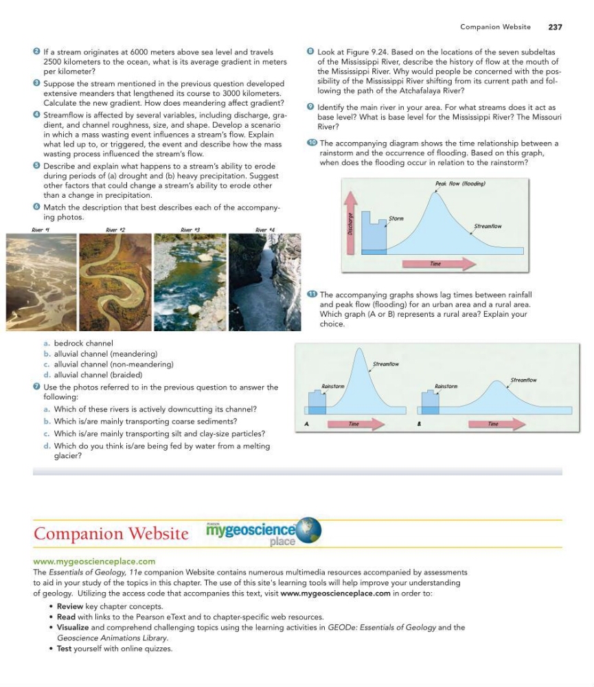
Match the description that best describes each of the accompanying photos.
6
5
4
3
2
Look at Figure 9.24. Based on the locations of the seven subdeltas
of the Mississippi River, describe the history of flow at the mouth of
the Mississippi River. Why would people be concerned with the possibility of the Mississippi River shifting from its current path and following the path of the Atchafalaya River?
Identify the main river in your area. For what streams does it act as
base level? What is base level for the Mississippi River? The Missouri
River?
The accompanying diagram shows the time relationship between a
rainstorm and the occurrence of flooding. Based on this graph,
when does the flooding occur in relation to the rainstorm?
10
9
8
a. bedrock channel
b. alluvial channel (meandering)
c. alluvial channel (non-meandering)
d. alluvial channel (braided)
Use the photos referred to in the previous question to answer the
following:
a. Which of these rivers is actively downcutting its channel?
b. Which is/are mainly transporting coarse sediments?
c. Which is/are mainly transporting silt and clay-size particles?
d. Which do you think is/are being fed by water from a melting
glacier?
7
The accompanying graphs shows lag times between rainfall
and peak flow (flooding) for an urban area and a rural area.
Which graph (A or B) represents a rural area? Explain your
choice.
11
Companion Website
www.mygeoscienceplace.com
The Essentials of Geology, 11e companion Website contains numerous multimedia resources accompanied by assessments
to aid in your study of the topics in this chapter. The use of this site's learning tools will help improve your understanding
of geology. Utilizing the access code that accompanies this text, visit www.mygeoscienceplace.com in order to:
• Review key chapter concepts.
• Read with links to the Pearson eText and to chapter-specific web resources.
• Visualize and comprehend challenging topics using the learning activities in GEODe: Essentials of Geology and the
Geoscience Animations Library.
• Test yourself with online quizzes.
237
Companion Website
2500 kilometers to the ocean, what is its average gradient in meters
per kilometer?
Suppose the stream mentioned in the previous question developed
extensive meanders that lengthened its course to 3000 kilometers.
Calculate the new gradient. How does meandering affect gradient?
Streamflow is affected by several variables, including discharge, gradient, and channel roughness, size, and shape. Develop a scenario
in which a mass wasting event influences a stream’s flow. Explain
what led up to, or triggered, the event and describe how the mass
wasting process influenced the stream’s flow.
Describe and explain what happens to a stream’s ability to erode
during periods of (a) drought and (b) heavy precipitation. Suggest
other factors that could change a stream’s ability to erode other
than a change in precipitation.
Match the description that best describes each of the accompanying photos.
6
5
4
3
2
Look at Figure 9.24. Based on the locations of the seven subdeltas
of the Mississippi River, describe the history of flow at the mouth of
the Mississippi River. Why would people be concerned with the possibility of the Mississippi River shifting from its current path and following the path of the Atchafalaya River?
Identify the main river in your area. For what streams does it act as
base level? What is base level for the Mississippi River? The Missouri
River?
The accompanying diagram shows the time relationship between a
rainstorm and the occurrence of flooding. Based on this graph,
when does the flooding occur in relation to the rainstorm?
10
9
8
a. bedrock channel
b. alluvial channel (meandering)
c. alluvial channel (non-meandering)
d. alluvial channel (braided)
Use the photos referred to in the previous question to answer the
following:
a. Which of these rivers is actively downcutting its channel?
b. Which is/are mainly transporting coarse sediments?
c. Which is/are mainly transporting silt and clay-size particles?
d. Which do you think is/are being fed by water from a melting
glacier?
7
The accompanying graphs shows lag times between rainfall
and peak flow (flooding) for an urban area and a rural area.
Which graph (A or B) represents a rural area? Explain your
choice.
11
Companion Website
www.mygeoscienceplace.com
The Essentials of Geology, 11e companion Website contains numerous multimedia resources accompanied by assessments
to aid in your study of the topics in this chapter. The use of this site's learning tools will help improve your understanding
of geology. Utilizing the access code that accompanies this text, visit www.mygeoscienceplace.com in order to:
• Review key chapter concepts.
• Read with links to the Pearson eText and to chapter-specific web resources.
• Visualize and comprehend challenging topics using the learning activities in GEODe: Essentials of Geology and the
Geoscience Animations Library.
• Test yourself with online quizzes.
237
Companion Website