

Antarctic Polar Biome
469
0
50
100
150
200
0
5
10
15
Climatology (years)
Depth (m)
Production at DCM (%)
Zm (sigma)
Zeu
Pt (at DCM)
0.0
0.2
0.3
0.5
0.6
0.8
0.0
0.2
0.4
0.6
0.8
1.0
SeaWiFS (ANTA): September 1997 - January 2002
Surface Chl (mg m
-2
)
Pt (gC m
-2
d
-1
)
Pt d
-1
Chl m
-3
1998
1999
2000
2001
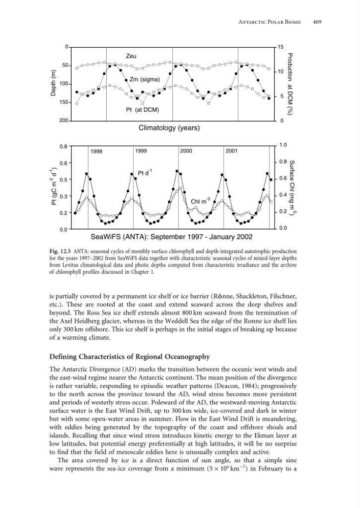
Fig. 12.5 ANTA: seasonal cycles of monthly surface chlorophyll and depth-integrated autotrophic production
for the years 1997–2002 from SeaWiFS data together with characteristic seasonal cycles of mixed-layer depths
from Levitus climatological data and photic depths computed from characteristic irradiance and the archive
of chlorophyll profiles discussed in Chapter 1.
is partially covered by a permanent ice shelf or ice barrier (Rnne, Shackleton, Filschner,
etc.). These are rooted at the coast and extend seaward across the deep shelves and
beyond. The Ross Sea ice shelf extends almost 800 km seaward from the termination of
the Axel Heidberg glacier, whereas in the Weddell Sea the edge of the Ronne ice shelf lies
only 300 km offshore. This ice shelf is perhaps in the initial stages of breaking up because
of a warming climate.
Defining Characteristics of Regional Oceanography
The Antarctic Divergence (AD) marks the transition between the oceanic west winds and
the east-wind regime nearer the Antarctic continent. The mean position of the divergence
is rather variable, responding to episodic weather patterns (Deacon, 1984); progressively
to the north across the province toward the AD, wind stress becomes more persistent
and periods of westerly stress occur. Poleward of the AD, the westward-moving Antarctic
surface water is the East Wind Drift, up to 300 km wide, ice-covered and dark in winter
but with some open-water areas in summer. Flow in the East Wind Drift is meandering,
with eddies being generated by the topography of the coast and offshore shoals and
islands. Recalling that since wind stress introduces kinetic energy to the Ekman layer at
low latitudes, but potential energy preferentially at high latitudes, it will be no surprise
to find that the field of mesoscale eddies here is unusually complex and active.
The area covered by ice is a direct function of sun angle, so that a simple sine
wave represents the sea-ice coverage from a minimum (5 × 10
6 km
−2 ) in February to a
469
0
50
100
150
200
0
5
10
15
Climatology (years)
Depth (m)
Production at DCM (%)
Zm (sigma)
Zeu
Pt (at DCM)
0.0
0.2
0.3
0.5
0.6
0.8
0.0
0.2
0.4
0.6
0.8
1.0
SeaWiFS (ANTA): September 1997 - January 2002
Surface Chl (mg m
-2
)
Pt (gC m
-2
d
-1
)
Pt d
-1
Chl m
-3
1998
1999
2000
2001
Fig. 12.5 ANTA: seasonal cycles of monthly surface chlorophyll and depth-integrated autotrophic production
for the years 1997–2002 from SeaWiFS data together with characteristic seasonal cycles of mixed-layer depths
from Levitus climatological data and photic depths computed from characteristic irradiance and the archive
of chlorophyll profiles discussed in Chapter 1.
is partially covered by a permanent ice shelf or ice barrier (Rnne, Shackleton, Filschner,
etc.). These are rooted at the coast and extend seaward across the deep shelves and
beyond. The Ross Sea ice shelf extends almost 800 km seaward from the termination of
the Axel Heidberg glacier, whereas in the Weddell Sea the edge of the Ronne ice shelf lies
only 300 km offshore. This ice shelf is perhaps in the initial stages of breaking up because
of a warming climate.
Defining Characteristics of Regional Oceanography
The Antarctic Divergence (AD) marks the transition between the oceanic west winds and
the east-wind regime nearer the Antarctic continent. The mean position of the divergence
is rather variable, responding to episodic weather patterns (Deacon, 1984); progressively
to the north across the province toward the AD, wind stress becomes more persistent
and periods of westerly stress occur. Poleward of the AD, the westward-moving Antarctic
surface water is the East Wind Drift, up to 300 km wide, ice-covered and dark in winter
but with some open-water areas in summer. Flow in the East Wind Drift is meandering,
with eddies being generated by the topography of the coast and offshore shoals and
islands. Recalling that since wind stress introduces kinetic energy to the Ekman layer at
low latitudes, but potential energy preferentially at high latitudes, it will be no surprise
to find that the field of mesoscale eddies here is unusually complex and active.
The area covered by ice is a direct function of sun angle, so that a simple sine
wave represents the sea-ice coverage from a minimum (5 × 10
6 km
−2 ) in February to a