

454
Chapter 12: The Southern Ocean
0
50
100
150
200
250
0
5
10
15
20
Climatology (years)
Depth (m)
Production at DCM (%)
Zm (sigma)
Zeu
Pt (at DCM)
0.00
0.20
0.40
0.60
0.80
1.00
0.20
0.24
0.28
0.32
0.36
0.40
SeaWiFS (SSTC): September 1997 - January 2002
Surface Chl (mg m -3
)
Pt d
-1
Chl m
-3
Pt (gC m
-2
d
-1
)
1998
1999
2000
2001
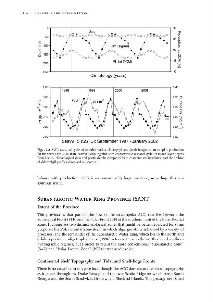
Fig. 12.3 SSTC: seasonal cycles of monthly surface chlorophyll and depth-integrated autotrophic production
for the years 1997–2002 from SeaWiFS data together with characteristic seasonal cycles of mixed-layer depths
from Levitus climatological data and photic depths computed from characteristic irradiance and the archive
of chlorophyll profiles discussed in Chapter 1.
balance with production. ISSG is an unreasonably large province, so perhaps this is a
spurious result.
Subantarctic Water Ring Province (SANT)
Extent of the Province
This province is that part of the flow of the circumpolar ACC that lies between the
Subtropical Front (STF) and the Polar Front (PF) at the southern limit of the Polar Frontal
Zone. It comprises two distinct ecological zones that might be better separated for some
purposes: the Polar Frontal Zone itself, in which algal growth is enhanced by a variety of
processes, and the remainder of the Subantarctic Water Ring, which lies to the north and
exhibits persistent oligotrophy. Banse (1996) refers to these as the northern and southern
hydrographic regimes, but I prefer to retain the more conventional “Subantarctic Zone”
(SAZ) and “Polar Frontal Zone” (PFZ) introduced earlier.
Continental Shelf Topography and Tidal and Shelf-Edge Fronts
There is no coastline in this province, though the ACC does encounter shoal topography
as it passes through the Drake Passage and the over Scotia Ridge on which stand South
Georgia and the South Sandwich, Orkney, and Shetland Islands. This passage near shoal
Chapter 12: The Southern Ocean
0
50
100
150
200
250
0
5
10
15
20
Climatology (years)
Depth (m)
Production at DCM (%)
Zm (sigma)
Zeu
Pt (at DCM)
0.00
0.20
0.40
0.60
0.80
1.00
0.20
0.24
0.28
0.32
0.36
0.40
SeaWiFS (SSTC): September 1997 - January 2002
Surface Chl (mg m -3
)
Pt d
-1
Chl m
-3
Pt (gC m
-2
d
-1
)
1998
1999
2000
2001
Fig. 12.3 SSTC: seasonal cycles of monthly surface chlorophyll and depth-integrated autotrophic production
for the years 1997–2002 from SeaWiFS data together with characteristic seasonal cycles of mixed-layer depths
from Levitus climatological data and photic depths computed from characteristic irradiance and the archive
of chlorophyll profiles discussed in Chapter 1.
balance with production. ISSG is an unreasonably large province, so perhaps this is a
spurious result.
Subantarctic Water Ring Province (SANT)
Extent of the Province
This province is that part of the flow of the circumpolar ACC that lies between the
Subtropical Front (STF) and the Polar Front (PF) at the southern limit of the Polar Frontal
Zone. It comprises two distinct ecological zones that might be better separated for some
purposes: the Polar Frontal Zone itself, in which algal growth is enhanced by a variety of
processes, and the remainder of the Subantarctic Water Ring, which lies to the north and
exhibits persistent oligotrophy. Banse (1996) refers to these as the northern and southern
hydrographic regimes, but I prefer to retain the more conventional “Subantarctic Zone”
(SAZ) and “Polar Frontal Zone” (PFZ) introduced earlier.
Continental Shelf Topography and Tidal and Shelf-Edge Fronts
There is no coastline in this province, though the ACC does encounter shoal topography
as it passes through the Drake Passage and the over Scotia Ridge on which stand South
Georgia and the South Sandwich, Orkney, and Shetland Islands. This passage near shoal