

404
Chapter 11: The Pacific Ocean
0.00
0.40
0.80
1.20
1.60
2.00
0.00
1.00
2.00
3.00
4.00
5.00
SeaWiFS (CALC): September 1997 - January 2002
Surface Chl (mg m -3
)
Pt d
-1
Chl m
-3
1999
2000
2001
2002
Pt (gC m
-2
d
-1
)
0
20
40
60
80
100
0
5
10
15
20
25
Climatology (years)
Depth (m)
Production at DCM (%)
Zm (sigma)
Zeu
Pt (at DCM)
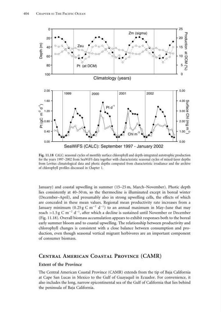
Fig. 11.18 CALC: seasonal cycles of monthly surface chlorophyll and depth-integrated autotrophic production
for the years 1997–2002 from SeaWiFS data together with characteristic seasonal cycles of mixed-layer depths
from Levitus climatological data and photic depths computed from characteristic irradiance and the archive
of chlorophyll profiles discussed in Chapter 1.
January) and coastal upwelling in summer (15–25 m, March–November). Photic depth
lies consistently at 40–50 m, so the thermocline is illuminated except in boreal winter
(December–April), and presumably also in strong upwelling cells, the effects of which
are concealed in these mean values. Regional mean productivity rate increases from a
January minimum (025 g C m
−2 d
−1 ) to an annual maximum in May–June that may
reach >15 g C m
−2 d
−1 , after which a decline is sustained until November or December
(Fig. 11.18). Overall biomass accumulation appears to exhibit responses both to the boreal
early summer bloom and to coastal upwelling. The relationship between productivity and
chlorophyll changes is consistent with a close balance between consumption and production, even though seasonal vertical migrant herbivores are an important component
of consumer biomass.
Central American Coastal Province (CAMR)
Extent of the Province
The Central American Coastal Province (CAMR) extends from the tip of Baja California
at Cape San Lucas in Mexico to the Gulf of Guayaquil in Ecuador. For convenience, it
also includes the long, narrow epicontinental sea of the Gulf of California that lies behind
the peninsula of Baja California.
Chapter 11: The Pacific Ocean
0.00
0.40
0.80
1.20
1.60
2.00
0.00
1.00
2.00
3.00
4.00
5.00
SeaWiFS (CALC): September 1997 - January 2002
Surface Chl (mg m -3
)
Pt d
-1
Chl m
-3
1999
2000
2001
2002
Pt (gC m
-2
d
-1
)
0
20
40
60
80
100
0
5
10
15
20
25
Climatology (years)
Depth (m)
Production at DCM (%)
Zm (sigma)
Zeu
Pt (at DCM)
Fig. 11.18 CALC: seasonal cycles of monthly surface chlorophyll and depth-integrated autotrophic production
for the years 1997–2002 from SeaWiFS data together with characteristic seasonal cycles of mixed-layer depths
from Levitus climatological data and photic depths computed from characteristic irradiance and the archive
of chlorophyll profiles discussed in Chapter 1.
January) and coastal upwelling in summer (15–25 m, March–November). Photic depth
lies consistently at 40–50 m, so the thermocline is illuminated except in boreal winter
(December–April), and presumably also in strong upwelling cells, the effects of which
are concealed in these mean values. Regional mean productivity rate increases from a
January minimum (025 g C m
−2 d
−1 ) to an annual maximum in May–June that may
reach >15 g C m
−2 d
−1 , after which a decline is sustained until November or December
(Fig. 11.18). Overall biomass accumulation appears to exhibit responses both to the boreal
early summer bloom and to coastal upwelling. The relationship between productivity and
chlorophyll changes is consistent with a close balance between consumption and production, even though seasonal vertical migrant herbivores are an important component
of consumer biomass.
Central American Coastal Province (CAMR)
Extent of the Province
The Central American Coastal Province (CAMR) extends from the tip of Baja California
at Cape San Lucas in Mexico to the Gulf of Guayaquil in Ecuador. For convenience, it
also includes the long, narrow epicontinental sea of the Gulf of California that lies behind
the peninsula of Baja California.