

396
Chapter 11: The Pacific Ocean
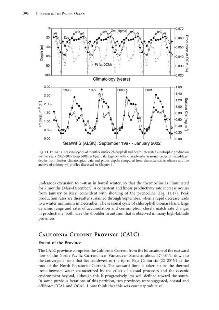
Fig. 11.17 ALSK: seasonal cycles of monthly surface chlorophyll and depth-integrated autotrophic production
for the years 2002–2005 from MODIS-Aqua data together with characteristic seasonal cycles of mixed-layer
depths from Levitus climatological data and photic depths computed from characteristic irradiance and the
archive of chlorophyll profiles discussed in Chapter 1.
undergoes excursion to >40 m in boreal winter, so that the thermocline is illuminated
for 7 months (May–December). A consistent and linear productivity rate increase occurs
from January to May, coincident with shoaling of the pycnocline (Fig. 11.17). Peak
production rates are thereafter sustained through September, when a rapid decrease leads
to a winter minimum in December. The seasonal cycle of chlorophyll biomass has a large
dynamic range and rates of accumulation and consumption closely match rate changes
in productivity; both have the shoulder in autumn that is observed in many high-latitude
provinces.
California Current Province (CALC)
Extent of the Province
The CALC province comprises the California Current from the bifurcation of the eastward
flow of the North Pacific Current near Vancouver Island at about 47–48
N, down to
the convergent front that lies southwest of the tip of Baja California (22–23
N) at the
root of the North Equatorial Current. The seaward limit is taken to be the thermal
front between water characterized by the effect of coastal processes and the oceanic
environment beyond, although this is progressively less well defined toward the south.
In some previous iterations of this partition, two provinces were suggested, coastal and
offshore: CCAL and OCAL. I now think that this was counterproductive.
Chapter 11: The Pacific Ocean
Fig. 11.17 ALSK: seasonal cycles of monthly surface chlorophyll and depth-integrated autotrophic production
for the years 2002–2005 from MODIS-Aqua data together with characteristic seasonal cycles of mixed-layer
depths from Levitus climatological data and photic depths computed from characteristic irradiance and the
archive of chlorophyll profiles discussed in Chapter 1.
undergoes excursion to >40 m in boreal winter, so that the thermocline is illuminated
for 7 months (May–December). A consistent and linear productivity rate increase occurs
from January to May, coincident with shoaling of the pycnocline (Fig. 11.17). Peak
production rates are thereafter sustained through September, when a rapid decrease leads
to a winter minimum in December. The seasonal cycle of chlorophyll biomass has a large
dynamic range and rates of accumulation and consumption closely match rate changes
in productivity; both have the shoulder in autumn that is observed in many high-latitude
provinces.
California Current Province (CALC)
Extent of the Province
The CALC province comprises the California Current from the bifurcation of the eastward
flow of the North Pacific Current near Vancouver Island at about 47–48
N, down to
the convergent front that lies southwest of the tip of Baja California (22–23
N) at the
root of the North Equatorial Current. The seaward limit is taken to be the thermal
front between water characterized by the effect of coastal processes and the oceanic
environment beyond, although this is progressively less well defined toward the south.
In some previous iterations of this partition, two provinces were suggested, coastal and
offshore: CCAL and OCAL. I now think that this was counterproductive.