

Pacific Coastal Biome
389
0.16
0.24
0.32
0.40
0.48
0.07
0.08
0.10
0.11
0.13
0.14
SeaWiFS (SPSG): September 1997 - January 2002
Surface Chl (mg m -3
)
Pt d
-1
Chl m
-3
Pt (gC m
-2
d
-1
)
1998
1999
2000
2001
20
30
40
50
60
70
80
90
100
0
5
10
15
20
25
30
Climatology (years)
Depth (m)
Production at DCM (%)
Zm (sigma)
Zeu
Pt (at DCM)
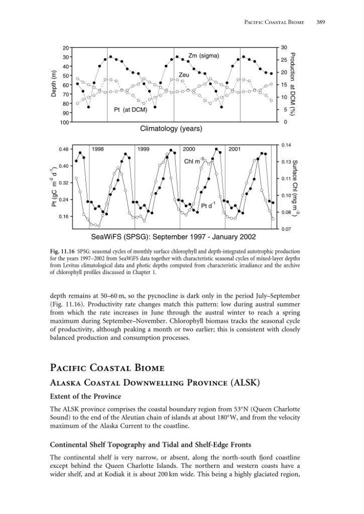
Fig. 11.16 SPSG: seasonal cycles of monthly surface chlorophyll and depth-integrated autotrophic production
for the years 1997–2002 from SeaWiFS data together with characteristic seasonal cycles of mixed-layer depths
from Levitus climatological data and photic depths computed from characteristic irradiance and the archive
of chlorophyll profiles discussed in Chapter 1.
depth remains at 50–60 m, so the pycnocline is dark only in the period July–September
(Fig. 11.16). Productivity rate changes match this pattern: low during austral summer
from which the rate increases in June through the austral winter to reach a spring
maximum during September–November. Chlorophyll biomass tracks the seasonal cycle
of productivity, although peaking a month or two earlier; this is consistent with closely
balanced production and consumption processes.
Pacific Coastal Biome
Alaska Coastal Downwelling Province (ALSK)
Extent of the Province
The ALSK province comprises the coastal boundary region from 53
N (Queen Charlotte
Sound) to the end of the Aleutian chain of islands at about 180
W, and from the velocity
maximum of the Alaska Current to the coastline.
Continental Shelf Topography and Tidal and Shelf-Edge Fronts
The continental shelf is very narrow, or absent, along the north-south fjord coastline
except behind the Queen Charlotte Islands. The northern and western coasts have a
wider shelf, and at Kodiak it is about 200 km wide. This being a highly glaciated region,
389
0.16
0.24
0.32
0.40
0.48
0.07
0.08
0.10
0.11
0.13
0.14
SeaWiFS (SPSG): September 1997 - January 2002
Surface Chl (mg m -3
)
Pt d
-1
Chl m
-3
Pt (gC m
-2
d
-1
)
1998
1999
2000
2001
20
30
40
50
60
70
80
90
100
0
5
10
15
20
25
30
Climatology (years)
Depth (m)
Production at DCM (%)
Zm (sigma)
Zeu
Pt (at DCM)
Fig. 11.16 SPSG: seasonal cycles of monthly surface chlorophyll and depth-integrated autotrophic production
for the years 1997–2002 from SeaWiFS data together with characteristic seasonal cycles of mixed-layer depths
from Levitus climatological data and photic depths computed from characteristic irradiance and the archive
of chlorophyll profiles discussed in Chapter 1.
depth remains at 50–60 m, so the pycnocline is dark only in the period July–September
(Fig. 11.16). Productivity rate changes match this pattern: low during austral summer
from which the rate increases in June through the austral winter to reach a spring
maximum during September–November. Chlorophyll biomass tracks the seasonal cycle
of productivity, although peaking a month or two earlier; this is consistent with closely
balanced production and consumption processes.
Pacific Coastal Biome
Alaska Coastal Downwelling Province (ALSK)
Extent of the Province
The ALSK province comprises the coastal boundary region from 53
N (Queen Charlotte
Sound) to the end of the Aleutian chain of islands at about 180
W, and from the velocity
maximum of the Alaska Current to the coastline.
Continental Shelf Topography and Tidal and Shelf-Edge Fronts
The continental shelf is very narrow, or absent, along the north-south fjord coastline
except behind the Queen Charlotte Islands. The northern and western coasts have a
wider shelf, and at Kodiak it is about 200 km wide. This being a highly glaciated region,